All Activity
- Past hour
-
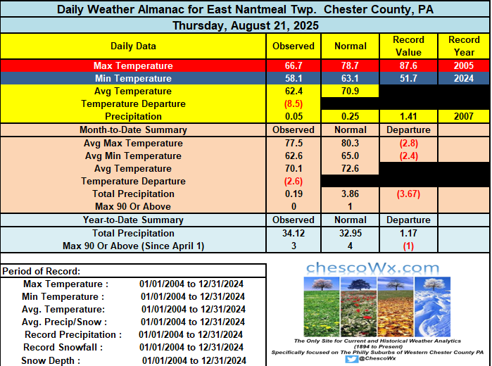
Some of the typically colder spots like Warwick Township made it down to 50.8 degrees this morning. A nice rebound in temperatures today but still below normal levels for late August. This pattern looks like it will continue for the upcoming week with the chilliest air so far this incoming fall season arriving by mid-week. Lows by Wednesday and Thursday morning may reach the 40's in the colder lower spots across the area. Temperatures through Monday will be not too far from normal in the upper 70's to low 80's. By Tuesday and Wednesday some of the ridge stations may struggle to get out of the 60's for afternoon highs. Rain has especially northern areas has been very scarce so far in August. Our best chances of rain this week looks like Sunday night.
-

E PA/NJ/DE Summer 2025 Obs/Discussion
ChescoWx replied to Hurricane Agnes's topic in Philadelphia Region
Some of the typically colder spots like Warwick Township made it down to 50.8 degrees this morning. A nice rebound in temperatures today but still below normal levels for late August. This pattern looks like it will continue for the upcoming week with the chilliest air so far this incoming fall season arriving by mid-week. Lows by Wednesday and Thursday morning may reach the 40's in the colder lower spots across the area. Temperatures through Monday will be not too far from normal in the upper 70's to low 80's. By Tuesday and Wednesday some of the ridge stations may struggle to get out of the 60's for afternoon highs. Rain has especially northern areas has been very scarce so far in August. Our best chances of rain this week looks like Sunday night.
-
I’ve got some friends at the coast for the swell posting video from sunrise… looks very big and well spaced.
-

Central & Eastern Pacific Thread
BarryStantonGBP replied to Windspeed's topic in Tropical Headquarters
-
2025 Atlantic Hurricane Season
BarryStantonGBP replied to BarryStantonGBP's topic in Tropical Headquarters
humberto has to wait -

Occasional Thoughts on Climate Change
donsutherland1 replied to donsutherland1's topic in Climate Change
On a serious note, there is genuine longer-term risk that the City could pass the point of sustainability, particularly if ongoing aridification depletes its access to water. -
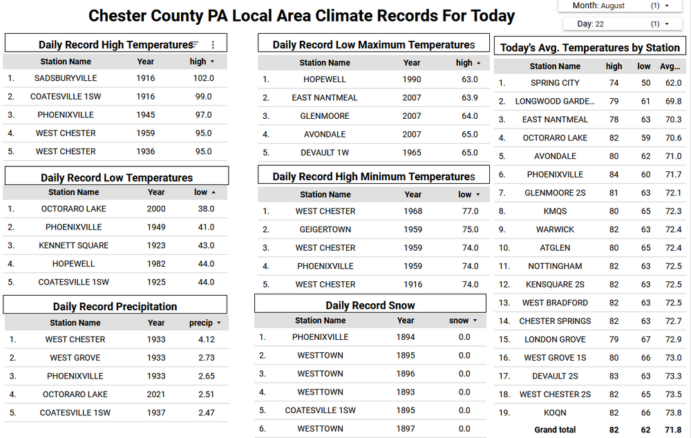
 It’s possible for JFK since they have had several last 90° days in August during recent years. But the usual warm spots like Newark can always sneak in more 90° days. Looks like our next warm up in the long range forecasts is for mid-September. First/Last Summary for JFK INTERNATIONAL AIRPORT, NY Each section contains date and year of occurrence, value on that date. Click column heading to sort ascending, click again to sort descending. Minimum 05-19 (2017) 07-20 (2013) 25 Mean 06-16 09-01 76 Maximum 07-12 (2023) 10-02 (2019) 127 2024 06-21 (2024) 91 08-28 (2024) 95 67 2023 07-12 (2023) 90 09-07 (2023) 92 56 2022 05-31 (2022) 94 08-27 (2022) 91 87 2021 05-22 (2021) 94 08-27 (2021) 93 96 2020 07-02 (2020) 90 08-27 (2020) 92 55 2019 06-27 (2019) 91 10-02 (2019) 95 96 2018 06-29 (2018) 91 09-04 (2018) 93 66 2017 05-19 (2017) 92 09-24 (2017) 92 127 2016 06-22 (2016) 92 09-09 (2016) 91 78 2015 06-21 (2015) 90 09-08 (2015) 91 78 2014 06-18 (2014) 91 09-02 (2014) 92 75 2013 06-24 (2013) 90 07-20 (2013) 96 25 2012 06-20 (2012) 94 09-01 (2012) 92 72 2011 06-09 (2011) 93 08-08 (2011) 92 59 2010 05-26 (2010) 91 09-08 (2010) 92 104
-
Occasional Thoughts on Climate Change
donsutherland1 replied to donsutherland1's topic in Climate Change
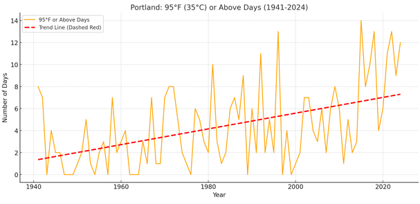
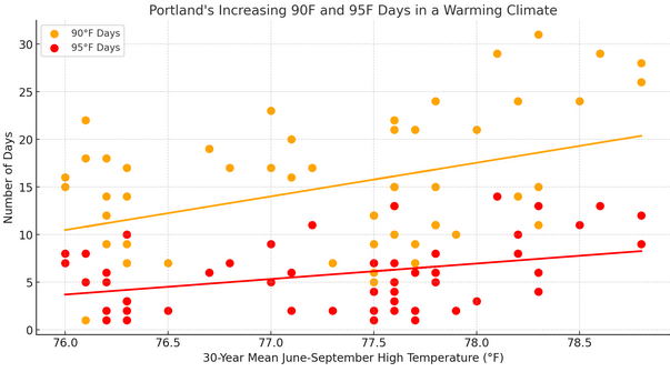
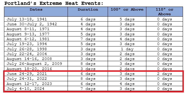
Portland, OR appears to be headed for an extreme heat event (Clarke et al., 2014 methodology) for the fifth year in a row. The City has been experiencing a rise in 90° and 95° days in its warming climate. 90° days are increasing by 1.45 days per decade. 95° days are increasing by 0.72 days per decade. Moreover, in Portland's warming climate, the 30-year mean June-September high temperature reached 78.0° in 2014. The frequency of extreme heat events has increased markedly to about once every 2.2 years (2014-2024). Prior to 2014, extreme heat events occurred once every 7.3 years.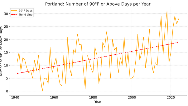
-
Even a broken clock gets it right on occasion. Definitely looking forward to an increase in sunshine and I'm good with a return back to the 80s as well.
-
August 22nd, 2019 We had no power for days. I literally thought a tornado came through west babylon. Trees down everywhere. Most insane straight line winds I’ve ever experienced possible tornados associated?
-
 56° this am... High temps of 69 and 73 for Wed and Thurs with 0.84" rain.
 -
will be hitting montrose and/or diversey harbors early sat and sun mornings anyone in the city want to come hang, shoot me a dm
-
Glad all is well with the knee Tom, Rehab is key, If its dead calm here i can radiate pretty well which it was, Quite foggy as well yesterday with the smoke off the Androscoggin River, Over the years when I've hunted, I would sit and let others move them around, Bagged a few deer this way, I'll be out first of October this year with my crossbow, I won't be passing on any deer this year like i did last year.
-
Hurricane Erin: 105 MPH - 945 mb - NNE @ 17
BarryStantonGBP replied to BarryStantonGBP's topic in Tropical Headquarters
OIIIIIIIII ERIN'S SCORING A FINAL GOAL FOR US LADS https://www.metoffice.gov.uk/blog/2025/met-office-weather-headline-review-aug-20 -
INVEST 99L FORMED: (40/50)
BarryStantonGBP replied to BarryStantonGBP's topic in Tropical Headquarters
What are they yapping about bruv -
Cloudy and foggy with a few sprinkles, 65.4/64.8. 0.79 in gauge when pulled for CoCoRaHS at 7 am. That storm continued south and dumped 4.27" on Roanoke airport, setting a daily record for them with lots of street/urban flooding.
-
What a glorious morning! Very rare occurrence in summer 2025.
-
INVEST 90L: Central Tropical Atlantic (80/90)
BarryStantonGBP replied to BarryStantonGBP's topic in Tropical Headquarters
2019 called -
she's right will be ruins in less than a decade once we enter the post the air-conditioning era
-
ANOTHER LEMON SLOP AOI (0/0)
BarryStantonGBP replied to BarryStantonGBP's topic in Tropical Headquarters
IT ROPED LMFAO Central Subtropical Atlantic: A small area of low pressure located well southwest of the Azores has weakened overnight, and no development is expected while it drifts northward. It roped. * Formation chance through 48 hours...low...near 0 percent. * Formation chance through 7 days...low...near 0 percent. -
No one's allowed to go swimming today at the beaches in Maine. I'm gonna take ride later to check it out.
-
-

Central PA Summer 2025
Mount Joy Snowman replied to Voyager's topic in Upstate New York/Pennsylvania
Low of 59. Gorgeous today and tomorrow, a touch muggy on Sunday, and then a taste of Fall next week. Football season is upon us boys, let's go! - Today
-
Damn waves are huge this morning. Long rollers perfect break. Go Go Go
-


