All Activity
- Past hour
-

The return of the elusive Nor'easter. Drought buster or bust?
WxUSAF replied to dailylurker's topic in Mid Atlantic
Would still be a nice soaking rain for most. It’s the best of the options at this point outside the NAM. -
Until it go pukie Dim sun en route
-
Multiple big snowstorms missed to our south from 2-6-80 to 3-3-80 with 32.6” at Norfolk and only 2.3” at JFK. Data for Norfolk Area, VA (ThreadEx) Click column heading to sort ascending, click again to sort descending. 1980-02-06 35 23 11.8 1980-02-07 37 26 0.6 1980-02-08 38 23 0.0 1980-02-09 37 29 2.3 1980-02-10 34 13 4.2 1980-02-11 40 9 0.0 1980-02-12 37 16 0.0 1980-02-13 36 22 0.0 1980-02-14 50 19 0.0 1980-02-15 46 29 0.0 1980-02-16 50 32 0.0 1980-02-17 33 22 0.0 1980-02-18 42 19 0.0 1980-02-19 48 23 0.0 1980-02-20 58 34 0.0 1980-02-21 62 44 0.0 1980-02-22 72 48 0.0 1980-02-23 63 43 0.0 1980-02-24 55 43 0.0 1980-02-25 45 36 0.0 1980-02-26 42 28 T 1980-02-27 48 23 0.0 1980-02-28 46 32 T 1980-02-29 37 25 0.0 1980-03-01 25 18 8.1 1980-03-02 24 20 5.6 1980-03-03 36 20 T Data for JFK INTERNATIONAL AIRPORT, NY Click column heading to sort ascending, click again to sort descending. 1980-02-06 30 14 0.0 1980-02-07 33 28 T 1980-02-08 41 24 0.0 1980-02-09 32 23 0.0 1980-02-10 35 23 0.0 1980-02-11 37 20 0.0 1980-02-12 37 26 T 1980-02-13 38 26 0.0 1980-02-14 44 25 0.0 1980-02-15 36 29 T 1980-02-16 40 23 1.3 1980-02-17 27 19 0.0 1980-02-18 32 18 0.0 1980-02-19 41 26 0.0 1980-02-20 45 25 0.0 1980-02-21 56 32 0.0 1980-02-22 38 31 1.0 1980-02-23 49 34 0.0 1980-02-24 49 36 0.0 1980-02-25 41 30 0.0 1980-02-26 32 16 0.0 1980-02-27 36 16 T 1980-02-28 30 22 0.0 1980-02-29 22 9 0.0 1980-03-01 24 8 T 1980-03-02 26 12 T 1980-03-03 40 15 0.0
-

The return of the elusive Nor'easter. Drought buster or bust?
nw baltimore wx replied to dailylurker's topic in Mid Atlantic
I saw that but didn’t try it. I had the three cask aged bottle pours. GD they do good aged sours. To make this a weather related post…..overcast, breezy and kinda chilly this afternoon. -

The return of the elusive Nor'easter. Drought buster or bust?
CAPE replied to dailylurker's topic in Mid Atlantic
HH GFS looks like a slight tick east so far. -

The return of the elusive Nor'easter. Drought buster or bust?
Weather Will replied to dailylurker's topic in Mid Atlantic
We all know that the lowest amount usually verifies... -
The return of the elusive Nor'easter. Drought buster or bust?
Weather Will replied to dailylurker's topic in Mid Atlantic
WB 18Z RDPS ticked east. Looks as bad as ICON.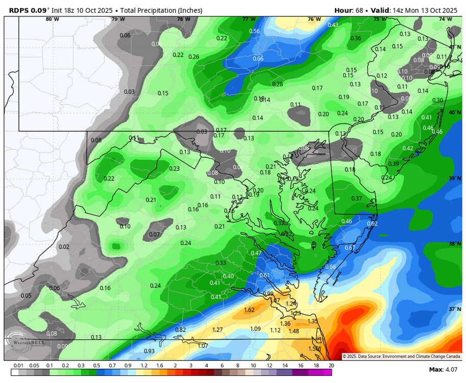
-
 Icon is better for some but not all lol And rgem looks fairly nice. To the end of run
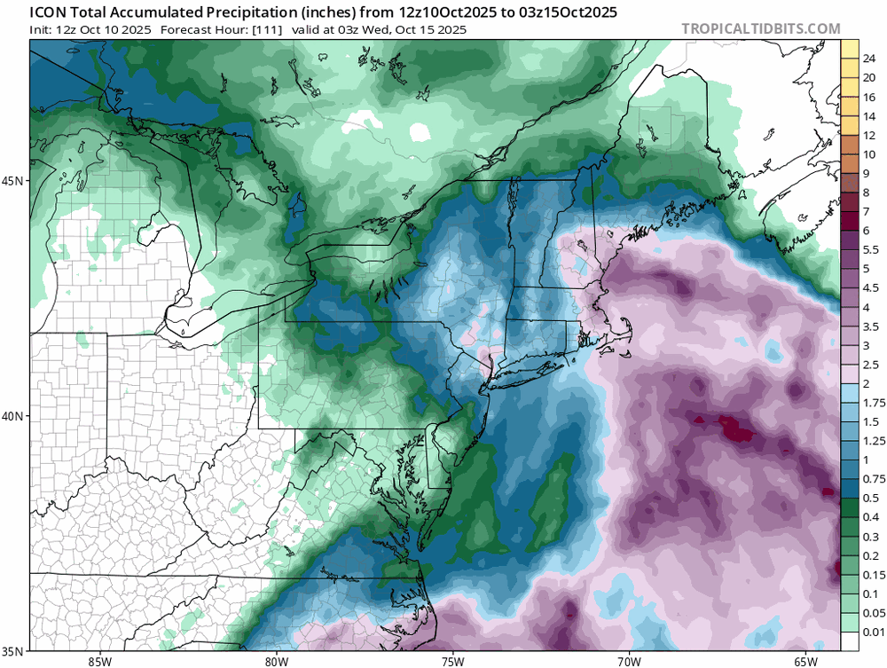
-

The return of the elusive Nor'easter. Drought buster or bust?
IronTy replied to dailylurker's topic in Mid Atlantic
So either I'm gonna get 3"+ of rain per the NAM or it's just gonna be cloudy per the ICON. We are so back. -
The return of the elusive Nor'easter. Drought buster or bust?
CAPE replied to dailylurker's topic in Mid Atlantic
It's always complicated. We just can't know...yet -

The return of the elusive Nor'easter. Drought buster or bust?
Amped replied to dailylurker's topic in Mid Atlantic
Medium range rug pulls is what our region does best. -
Brexit
-

The return of the elusive Nor'easter. Drought buster or bust?
dailylurker replied to dailylurker's topic in Mid Atlantic
A couple more runs and we'll be back to sunny and beautiful like the forecast was a few days ago lol. Fingers crossed -
The return of the elusive Nor'easter. Drought buster or bust?
Weather Will replied to dailylurker's topic in Mid Atlantic
WB 18Z ICON, which did well with last coastal, is still a whiff.
-

The return of the elusive Nor'easter. Drought buster or bust?
TSSN+ replied to dailylurker's topic in Mid Atlantic
Comedy. This stuff writes itself.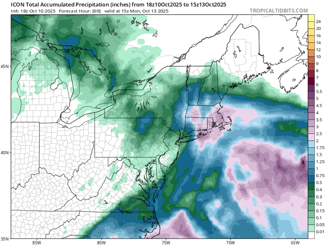
-

The return of the elusive Nor'easter. Drought buster or bust?
WEATHER53 replied to dailylurker's topic in Mid Atlantic
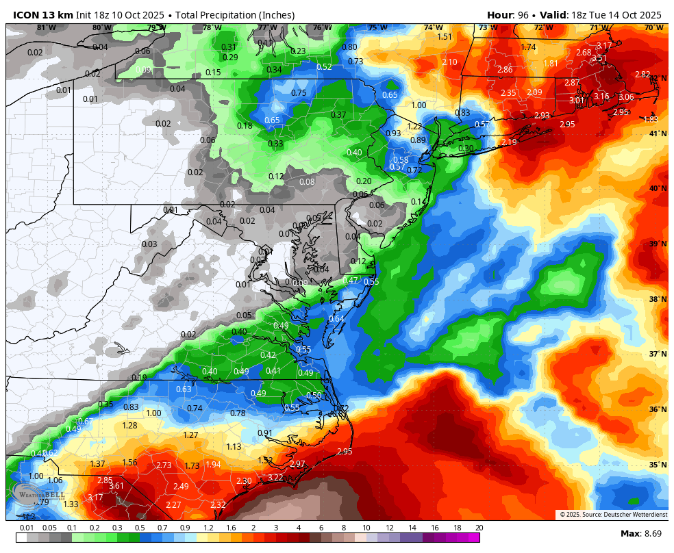
Forecasters catching on now. Models mean zip. Look at the radar and other tools. Already a solid east to west movement of rain down the coast . This won’t be missing DC to the east. Sat: Rain developing late . Sat night:Rain , , heavy at times with ne winds increasing increasing 20-30mph Sunday : Rainy and raw with ne winds 20-30 mph, sustained 25-35mph possible, gusts to 40 and gusts to 50 possible, chilly highs 55-60 Monday: Rainy ending in afternoon and windy, DC area rainfall 1-3” Little change in my forecast since Monday - Today
-
Long work day today, is the storm off? Is it back on? Off again? Winter cancel?
-
 ICON and RGEM both look abysmal
 -

The return of the elusive Nor'easter. Drought buster or bust?
ravensrule replied to dailylurker's topic in Mid Atlantic
I’m guaranteeing you 2” if you follow my instructions. -
Yeah looks like a weak nor'easter, nothing we haven't seen a billion times. Wish it missed but we do need the rain.
-
Would’ve loved radar from this point. Cool storm
-
The return of the elusive Nor'easter. Drought buster or bust?
CAPE replied to dailylurker's topic in Mid Atlantic
Mount Holly still sticking with the general idea of a high impact event. This little snippet is semi-interesting from their AFD- Guidance will likely continue to struggle and vary from run to run with this system until it actually forms a well defined low pressure center sometime Saturday or Saturday night. All previously issued watches remain in effect at this time due to the continued uncertainty in timing, severity, and inland extent of impacts. -
 It’s doing its typical over amped garbage.
 -
Temperatures started out the day in the 30s and 40s across the region. The coldest spots saw readings drop into the upper 20s. Lows included: Albany: 31° Atlantic City: 40° Binghamton: 31° Boston: 41° Bridgeport: 40° Danbury: 31° Hartford: 29° Islip: 40° Montgomery: 26° (old record: 27°, 2000) New Haven: 39° New York City-Central Park: 46° New York City-JFK Airport: 43° New York City-LaGuardia Airport: 48° Newark: 41° Philadelphia: 45° Poughkeepsie: 28° Sussex: 29° Trenton: 39° Westhampton: 31° White Plains: 42° Temperatures will moderate during the weekend, but rain will arrive on Sunday. Highs should reach the middle and upper 60s tomorrow and lower and middle 60s on Sunday. A strong nor'easter will bring periods of rain and strong winds to parts of the region. Uncertainty as to amounts and locations of the heaviest rainfall has increased on the guidance, as a complex phasing situation is involved. For now, it still appears that a general 1"-3" rainfall is likely across New York City and its nearby suburbs, along with winds that will gust past 40 mph. Long Island could see 2"-4" of rain. Winds in this region could gust to 60 mph. There is the potential for lesser rainfall amounts along the Jersey Shore, but that is not yet certain. More revisions may be necessary after the overnight model cycles. A period of near normal to somewhat below normal temperatures and dry conditions will likely follow the nor-easter. In the 18 past years where Central Park saw at least two 80° or above highs and Newark saw at least two 84° or above highs during the first week of October, the temperature returned to 70° or above on at least one day during the second half of October in 17 (94.4%) of those cases. For all other cases, 84.1% saw at least one such high temperature during the second half of October. Therefore, the sharp cool spell very likely won't mean that New York City has seen its last 70° or above high temperature. The ENSO Region 1+2 anomaly was -0.1°C and the Region 3.4 anomaly was -0.5°C for the week centered around October 1. For the past six weeks, the ENSO Region 1+2 anomaly has averaged -0.15°C and the ENSO Region 3.4 anomaly has averaged -0.43°C. La Niña conditions will likely continue through mid-winter. The SOI was +18.82 today. The preliminary Arctic Oscillation (AO) was +1.044 today. Based on sensitivity analysis applied to the latest guidance, there is an implied 61% probability that New York City will have a warmer than normal October (1991-2020 normal). October will likely finish with a mean temperature near 58.9° (1.0° above normal). Supplemental Information: The projected mean would be 2.0° above the 1981-2010 normal monthly value.