All Activity
- Past hour
-
 1+1=3. Fact not opinion.
 -
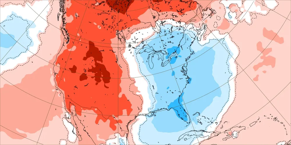
Luckily it's only November
-
The Pacific jet from hell needs to abate or it'll be more of the same garbage
-
Yup just more of the same. Doesn't matter how much blocking you get if you have a pacific jet on steroids. It's an extremely unfavorable pattern for snow.
-
 So . What's this snowstorm you speak in of for next weekend?
 -
Soaring +SOI, cooling subsurface (-3C) and surface SSTs, constructive interference with the -IOD/-PDO and the continued enhanced trades/EWBs in the CPAC leads me to believe this event doesn’t peak until either the tail end of this month or more likely early-mid December. As I said yesterday….a very well coupled canonical La Niña system is in place
-

November 2025 general discussions and probable topic derailings ...
SnoSki14 replied to Typhoon Tip's topic in New England
People can deny all they want but it won't change reality. How the factual equivalent of 2+2=4 with regards to anthropogenic climate change became political is baffling. But hey I guess you can call this warming a blip in the history of the planet. Once humans wipe themselves out, temperatures and the climate will eventually drop & stabilize. -

November 2025 general discussions and probable topic derailings ...
Brewbeer replied to Typhoon Tip's topic in New England
elect a convicted felon, get a criminal administration. everyone stay safe -
.33
-
Was not expecting loud thunder last night. Picked up .26 .
-
 Pouring now too. Now it holds up leaf cleanup until noon at least. Triggering
 -

Central PA Fall Discussions and Obs
mahantango#1 replied to ChescoWx's topic in Upstate New York/Pennsylvania
.05 rain last night and 44 and a very thick fog this morning. -

Central PA Fall Discussions and Obs
pawatch replied to ChescoWx's topic in Upstate New York/Pennsylvania
47 degrees and foggy,but at least no wind. -
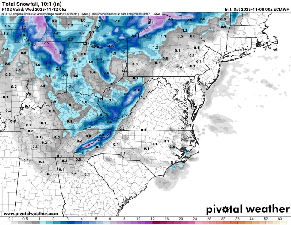
Not really seeing much deviation in this dominant northern stream track through the lakes or the hugger tracks in the near term. Colder air rushes in behind the storm in a few days. Then the following week we warm back up closer to seasonal levels or even above. EPS Nov 10 to 17 EPS Nov 17 to 24

-
GFS is not as impressive but the Euro has been leading the way this week in my opinion. Sent from my SM-G998U using Tapatalk
.thumb.jpg.c537204f4506c2d82ad2f4f3302b692d.jpg)
-
Overnight Euro looks really good. Looks to start fast and furious around midnight Monday morning. This looks like a classic mid-winter upslope snow event. I do think there will be spots that see close to a foot especially right along the border. It's going to be very windy, temps will crash, and this will feel like January. Sent from my SM-G998U using Tapatalk
-
I guess. I know oaks are in the beech family, but beech will hold their leaves until spring.
-
Matches the pattern of a step-down following the other 160+ ACE years like we had in 2024. While we have been in a new RI and Cat 5 hurricane era last decade, we haven’t been able to replicate the 2003-2005 high ACE 3 years in a row. But it also means that we haven’t had and really low ACE years like 2013 and 2014. Plus we have been getting the activity lulls from late August into early September before very strong late seasons.
-

November 2025 general discussions and probable topic derailings ...
dendrite replied to Typhoon Tip's topic in New England
Let’s keep it about weather today. Maybe I’ll separate out the posts into a separate thread later, but I’m not sure what more constructively needs to be said. Tickled 50° overnight, but back down to 45.7°. 0.07” I see DIT poured again. Unreal. -
Winter Storm Watches are up along the southern shore of Lake Michigan from Cook County, IL to Berrien County, MI. 6-12” possible. Probably more in Porter and LaPorte Counties. Thundersnow possible. Rates of 2-4” per hour. The IWX forecast discussion is one of the best reads in a long time. Winds over 35+ mph, 6+” of snow and leaves on the trees are going to be a perfect recipe for major tree damage. The TV Mets going super conservative due to ground temps are going to have to backtrack big time. The rates and timing will overcome a warm ground in no time. This are going be a memorable event for localized areas.
-
November 2025 general discussions and probable topic derailings ...
dendrite replied to Typhoon Tip's topic in New England
Black Friday -
Yesterday was a dark day for the forum. With violent outbursts and venom . A dark and doomsday scenario very similar to what the once great city of New York will soon experience. A real shame what went on. Had .40 overnight . More than expected. Onto tracking the snowstorm next weekend.
- Today
-

E PA/NJ/DE Autumn 2025 Obs/Discussion
Birds~69 replied to PhiEaglesfan712's topic in Philadelphia Region
Itt sure as hell wasn't a gully washer and it's out of here at 6:20 a.m. Guessing .2"-ish... could be completely wrong. 54F -
marcescence https://extension.umd.edu/resource/mystery-marcescence
-

November 2025 general discussions and probable topic derailings ...
Ginx snewx replied to Typhoon Tip's topic in New England
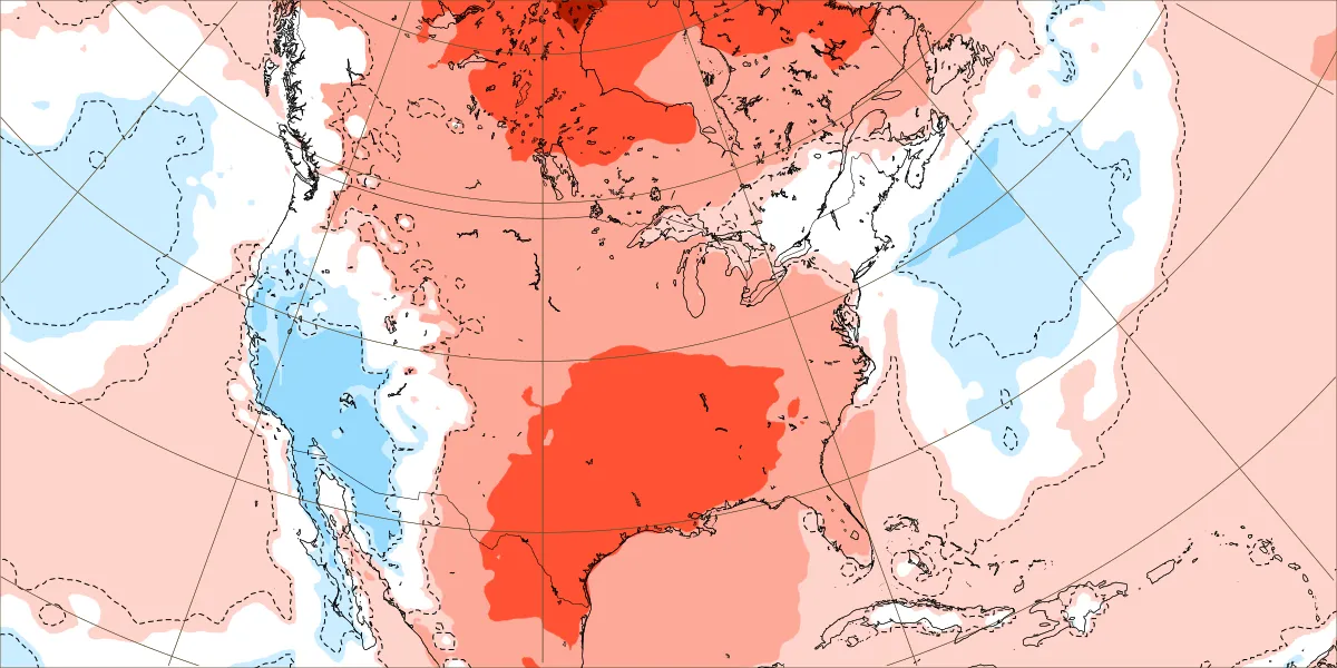
Snow down here before Tday melts the next day. Would love to see a wintry progression to the snow line with cold snow starting late November. Stormy days coming up with mountain snows. Pretty much average for now.


.jpg.28e18a0623f2f3b69945321a4a58775a.jpg)


