All Activity
- Past hour
-
Final call for late tonight/tom morning. NY/NJ area 1-2 thrilling stuff
-
all the NY/NJ climo sites are at or above normal through the date, LGA is right on the edge at +0.5 and EWR is +4.7, NYC is +1.6.
-
Welp. Not sure headed to Salamander Rock is going to help today. Even our local mountains can't even score. 10 years ago it would of been 31 and snow up there. Now 33 and rain lol
-

Is we back? February discussion thread
Baroclinic Zone replied to mahk_webstah's topic in New England
Wagons NOP. -
Careful, snowcrazed may go after you.
-
 Average high temp for 3/2 (360 hrs on EPS) at BWI is 51.5 and 3/9 is 57.4. So 50's would be average. Fyi, Eps has 1pm temps on 3/1 (354hrs) in mid 40's.
 -
I think I saw a map that has nyc south at or slightly below average on the season
-
As opposed to the birds being north, tricking the models? Take the rose colored glasses off and post objective analysis. No more radar hallucination.
-
Friday/Sarurday still looks doable. It could be a Rainer but close here.
-
It can still snow in March.
-
He loves WPC
-
My Columbia Sunday morning low 33.3 Current 7:30am Sunday 33.8
-
And? Move on if you dont want to discuss it. Let the people who want to, do it. Fucking schoolyard bully bullshit. Christ.
-
I should also at least own up to the fact that the strat kind of flopped: It tried and failed. Also, I don't really understand how all the east Asia correlation stuff works, but shouldn't this be a good look for us by around March 10- 15?
-
Is we back? February discussion thread
Baroclinic Zone replied to mahk_webstah's topic in New England
7 days from now? That could go up or down 2 dozen times from today till then. -
If only we could get this with some cold: But at least they are running the Barkely ultra marathon at Frozen Head in it!
-
Looking forwarded to my heavy rain
-
yeah it's definitely winding down....
-

-
-

E PA/NJ/DE Winter 2025-26 Obs/Discussion
BBasile replied to LVblizzard's topic in Philadelphia Region
This morning marks the third week of solid snow cover. Was the snow cover even around this long in 2010?.thumb.jpg.be94d23d03a092e6577dba8c40aadc45.jpg)
-
So many fake cold mornings.
-
We end winter
-
I’m up in blowing rock and just had a nice burst of snow
-
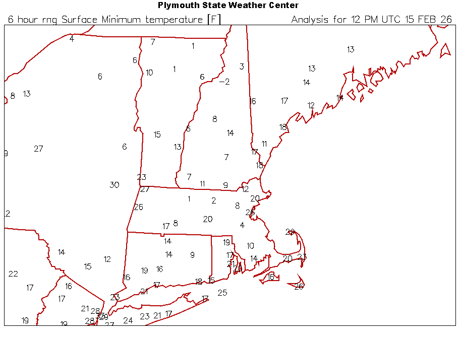
Mins are everywhere this morning. Low of 12° here but currently 20°.