All Activity
- Past hour
-

January 2026 regional war/obs/disco thread
mahk_webstah replied to Baroclinic Zone's topic in New England
Maybe an inch here Monday afternoon, 2 to 4 Tuesday night and Wednesday with 3 to 6 a real possibility, then a Friday Saturday rain or maybe mixed system. Then next week we’re rocking and rolling. Our rock solid pack isn’t going anywhere, but hopefully Friday and Saturday will clear the ice off the driveway. -

E PA/NJ/DE Winter 2025-26 Obs/Discussion
Birds~69 replied to LVblizzard's topic in Philadelphia Region
A decent blob E/SE of Levittown... 29F/Overcast here -
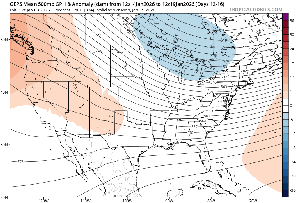
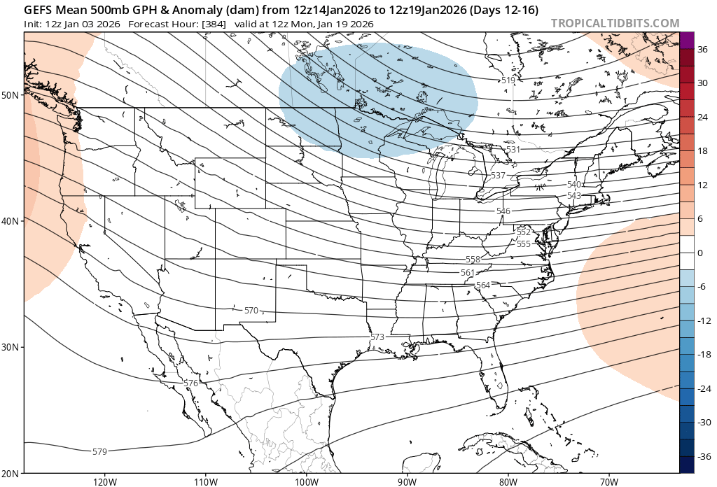
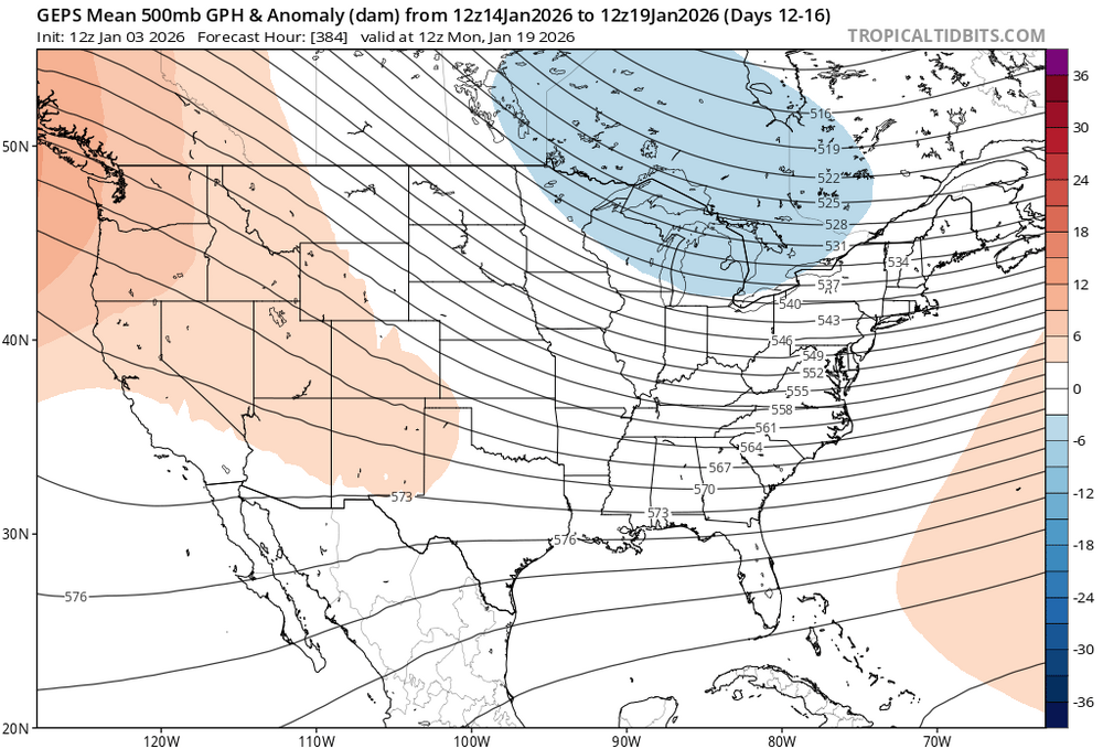
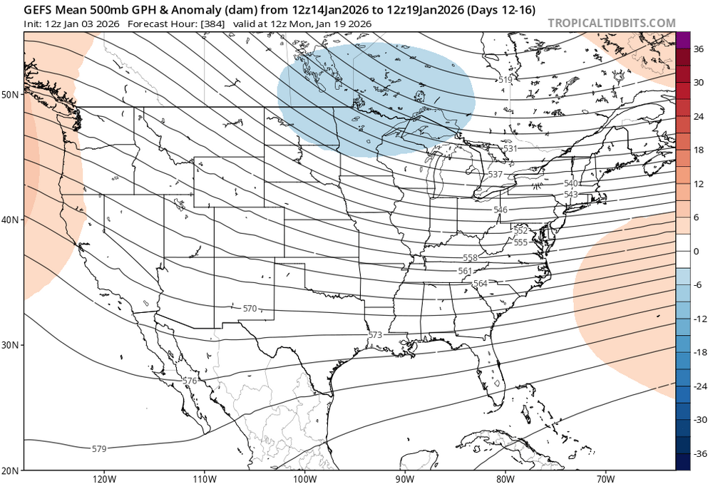
I think we can work with this look in the 10-15 day period
-
That scenario and time frame has been showing up on one model, ensemble, or another for a day and a half or 2 day, so the "threat" looks legit. It would be nice to get multiple model/ensemble support, then hold it. Once at that point, we can get Jeb to start a winning thread.
-

If you could re-experience ONE winter event....
weatherzen replied to cyclone77's topic in Lakes/Ohio Valley
Ohio Blizzard of 1978. Sent from my Pixel 6 using Tapatalk -

January 2026 regional war/obs/disco thread
Damage In Tolland replied to Baroclinic Zone's topic in New England
WTTTE -

January 2026 regional war/obs/disco thread
Snowcrazed71 replied to Baroclinic Zone's topic in New England
Northeast Weather Alert Over the past couple of months we’ve seen the trade winds steadily weaken, and at times even flip to brief westerlies as persistent convection has taken hold across the Pacific. That’s helped kick off a down-welling Kelvin Wave, which is forcing the subsurface warm pool to rise and slide east. In plain terms La Niña is fading right now, and the background state is already trending toward a developing +ENSO pattern as we move forward. With all due respect La Niña is effectively gone, even though it may still technically linger in the ocean for a short time on paper. The atmosphere has already begun shifting away from a true La Niña base state. I’m going to hold steady on my position, because no matter who you are in this field, you can’t ignore what’s right in front of you. I don’t flip back and forth with every single model run, I filter out the noise. Even in a field full of weeds, there are still solid tomatoes growing on the vine… you just have to know where and how to look for them. -

January 2026 regional war/obs/disco thread
binbisso replied to Baroclinic Zone's topic in New England
Gefs has it by the 11th. I have to agree with others that the warm ups in the extended have become muted as we get closer since late November. -
 Ocean Effect changed their profile photo
 -

January 2026 regional war/obs/disco thread
metagraphica replied to Baroclinic Zone's topic in New England
Yeah the past few years the January thaw has been like mid 50's or more. This coming warm up is much more subdued. Tenor of the season so far. Cold or cooler regime reigns. -

-

January 2026 regional war/obs/disco thread
CoastalWx replied to Baroclinic Zone's topic in New England
EPS AIfS definitely seem to bring back a weenie pattern quicker. Like 12-13 or so. -
January 2026 regional war/obs/disco thread
binbisso replied to Baroclinic Zone's topic in New England

-

Mid-Long Range Discussion 2026
WinstonSalemArlington replied to BooneWX's topic in Southeastern States
Deep Doom -
^^Return of the King
-
Alot of people ice fishing out on the lake today. Too breezy for me to go. I froze walking the dog for 30 minutes.
-
Looks good to me
-
Great post, rational POV. Everyone needs to tattoo this on their brain
-
January 2026 regional war/obs/disco thread
CoastalWx replied to Baroclinic Zone's topic in New England
If you want to have hopes and dreams and pray a crap pattern delivers more D-2” events that flip to rain go ahead. I’d prefer to wait until something that is much more conducive to winter weather. -

January 2026 regional war/obs/disco thread
ORH_wxman replied to Baroclinic Zone's topic in New England
That 1/10 system is looking more and more CADish…this is prob gonna be weak sauce in terms of a thaw for NNE. Def above normal but I can see where people say this isn’t like the torches we dealt with 2020-2024 -
I think that recent longer-range forecasting successes, part of the ever-improving state of NWP, have raised our expectations a bit too high. We're not yet at the point where we can expect the Week 2 period to always be forecasted with skill, even for ensemble systems.
-
Lol

-

January 2026 regional war/obs/disco thread
Sey-Mour Snow replied to Baroclinic Zone's topic in New England
North of the pike stays wintry through mid month. Post next weekends cutter we look to have chances south of pike right away by the 12/13th nice fantasy storm on 12z euro and AIFS day 10.. -
12z Euro is a bit more interesting today and certainly colder after next week.
-
January 2026 regional war/obs/disco thread
Snowcrazed71 replied to Baroclinic Zone's topic in New England
Is this guy a joke? He doesn't even speak with an ounce of professionalism. -
If you can get ice to form in the hudson then winter has a firm hold. These aren't short shots of cold either. A thaw,back in to the freezer in a few days. Thats basically the forecast. Btw its still cold outside!!.