All Activity
- Past hour
-
Wasn't last year more a product of it being dry over warm storm tracks?
-
https://x.com/BenNollWeather/status/1964063639037509647 Ben Noll @BenNollWeather Wildfire smoke from the Pacific Northwest and British Columbia will cause hazy skies along the East Coast into the weekend. Most of the smoke will be lofted up high, so air quality shouldn't be too bad, but eerie sunrises and sunsets may occur.
-
Getting a little worried about the Sunday stuff being too far east for me…may need the Sat afternoon/eve stuff to overperform.
-

2025 Atlantic Hurricane Season
BarryStantonGBP replied to BarryStantonGBP's topic in Tropical Headquarters
Don't bother with non-ens/ai models tbh -
Cool sunset incoming from this smoke coming through aloft. It reminds me of a 90's summer evening.
-
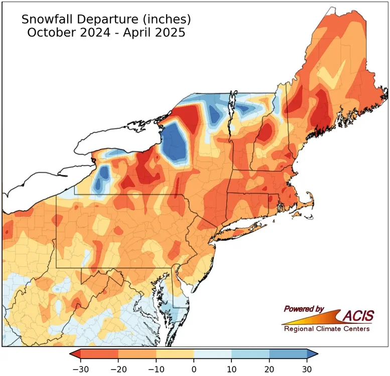
The much below average snowfall forecast from the seasonal models run during the fall of 2024 from Philly to Boston did work out. They even got the very low snowfall correct for Chicago. That’s what most on here follow anyway. A continuation of the warm storm tracks through the Great Lakes theme.
-

September 2025 OBS-Discussion centered NYC subforum
donsutherland1 replied to wdrag's topic in New York City Metro
The 0.48" rainfall at Bridgeport today broke the daily record for September 5. The old mark of 0.44" was set in 2012. -

September 2025 OBS-Discussion centered NYC subforum
WestBabylonWeather replied to wdrag's topic in New York City Metro
Last “warm” night of the season maybe? -
High of 89. Dew points in the mid 70's made it feel hot.
-

2025-2026 Fall/Winter Mountain Thread
Maggie Valley Steve replied to Buckethead's topic in Southeastern States
Woke up at 4:30 this morning and it was 58. No rain at the house today and I had a high of 74. Lots of Bikers in town which is a good thing for our Valley. Folks are slowly coming back after almost a year for the Helene Anniversary. -
Euro and GFS both showing nothing through September 20. Time to start bringing 2013 into conversation...
-
77/55 Another grade-A quality day.
-

E PA/NJ/DE Autumn 2025 Obs/Discussion
LVblizzard replied to PhiEaglesfan712's topic in Philadelphia Region
What’s up with the thick haze today? It doesn’t look like any Canadian wildfire smoke is nearby. -
29 years ago tonight and tomorrow, Hurricane Fran created a nightmare of destruction across Virginia. Winds to nearly 53 mph and nearly 8 inches of rainfall at my place.
-

September 2025 OBS-Discussion centered NYC subforum
wdrag replied to wdrag's topic in New York City Metro
May start a thread at 630AM Saturday for OBS-NOWCAST fairly widespread svr and a few Possible FF along I95 corridor. Model trends important and so am not committed yet but I think we're going to be pretty interested in the activity, especially for SEPT. SVR threat seems larger than the FF due to the recent dryness on and east of I95. However NNJ - central NJ inside of I95... be on your toes and no hanging out on stream banks once this system gets going. There were very sharp rises (and falls) of small streams last evening . Might be more extreme tomorrow. Aquiet period Sat evening before the widespread moderate rains with embedded thunder occur overnight Sat. Eastern LI probably not too much til maybe e Sunday morning -
More 30s on the way for tonight and tomorrow night. Gave in and turned on the ol' furnace. Gotta be a record earliest for that here.
-
2025-2026 ENSO
donsutherland1 replied to 40/70 Benchmark's topic in Weather Forecasting and Discussion
Here you go:
-
some models have 91l forming in the subtropics but I've already pressed X to doubt the atlantic = dubai or Karachi RIGHT NOW
-
Sunday is ruined. Wire to wire Rainer
- Today
-
Snowman19 seeing this post.

-
I just found Sept 2M forecasts for Dec and Jan individually though not Sept for DJF: https://charts.ecmwf.int/products/seasonal_system5_standard_2mtm?area=NAME&base_time=202509010000&stats=ensm&valid_time=202510020000 @donsutherland1@mitchnick
-
2025 Atlantic Hurricane Season
BarryStantonGBP replied to BarryStantonGBP's topic in Tropical Headquarters
Now GDM has 91L "Gabby" reforming in the subtropics "Humberto" becomes long track CV major "Imelda" goes for the gulf -
2025-2026 ENSO
donsutherland1 replied to 40/70 Benchmark's topic in Weather Forecasting and Discussion
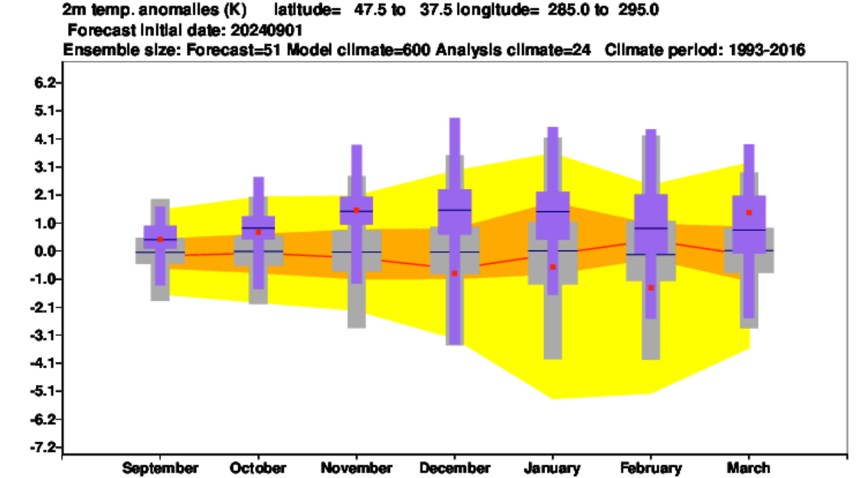
It was. Notice how similar the map looks to last September's outlook for the past winter. I suspect that the similarity reveals that the expected ENSO state plays a disproportionate role in the seasonal forecasts. -
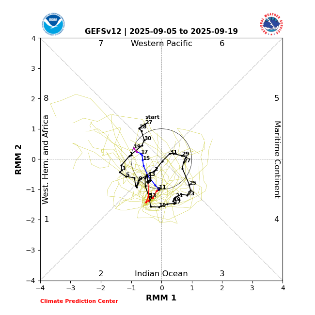
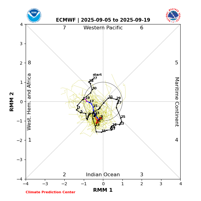
In addition: The last few GEFS and EPS runs have forecasted MJO in the relatively favorable phases of 2, 1, and 8 through Sept. 19 and this would probably extend at least through the rest of Sept per longer term model guidance and climo:
-
September 2025 OBS-Discussion centered NYC subforum
donsutherland1 replied to wdrag's topic in New York City Metro
Overnight, New York City saw its biggest one- and two-day rainfall since August 20 and August 20-21. The guidance has continued to increase rainfall amounts for later Saturday into Sunday with some of the guidance showing the potential for an inch or more of rain in places. As a result, this could be New York City's biggest rainfall since 2.64" fell on July 14. That rainfall was highlighted by an hourly figure of 2.07". September 6 will also be the 17th anniversary of a widespread rainstorm that produced daily record figures across the New York City region and nearby southern New England. Daily records set in 2008 included: Bridgeport: 2.90" Danbury: 5.96" Hartford: 5.22" Islip: 2.29" New Haven: 3.31" New York City-Central Park: 3.26" New York City-JFK Airport: 2.51" New York City-LaGuardia Airport: 3.21" Newark: 3.64" Poughkeepsie: 2.20" Providence: 3.95" Westhampton: 2.32" White Plains: 4.42" In terms of temperatures, tomorrow will be another warm day. Temperatures will top out in the lower and middle 80s before another cooler air mass moves into the region. A few of the warmer spots could top out in the upper 80s. Following the passage of a strong cold front, temperatures will mainly top out in the 70s during the daytime and fall into the 50s at nighttime in New York City through at least the middle of next week. Additional showers or rain is possible around midweek. The ENSO Region 1+2 anomaly was -0.3°C and the Region 3.4 anomaly was -0.4°C for the week centered around August 27. For the past six weeks, the ENSO Region 1+2 anomaly has averaged +0.33°C and the ENSO Region 3.4 anomaly has averaged -0.32°C. La Niña conditions will likely develop during mid- or late-autumn. The SOI was +17.71 today. The preliminary Arctic Oscillation (AO) was -0.231 today.