All Activity
- Past hour
-

26th-27th event, coming at us like a wounded duck.
Sey-Mour Snow replied to Go Kart Mozart's topic in New England
RGEM nice bump up like NAM -
yeah that sucks lol
-
It's unfortunate that this model will replace the NAM. As bad as the NAM can be, I can't argue that this model has any more skill.
-

26th-27th event, coming at us like a wounded duck.
weatherwiz replied to Go Kart Mozart's topic in New England
The one I remember best was November 2018. NJ into SW CT got absolutely crushed...that was with a SWFE I think but that was wild. I think Newark got something like 6-7" of snow. What made this event worse was it occurred during evening rush hour. -
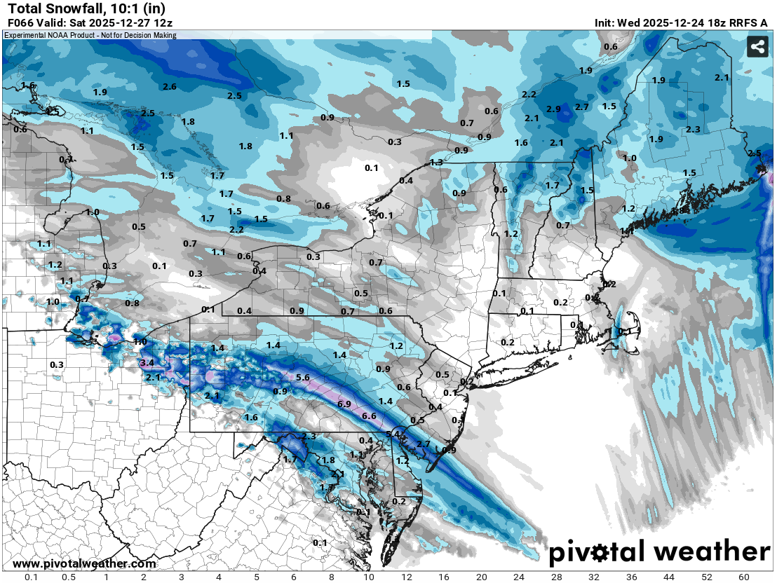
Tomorrow will be a mainly dry day with readings topping out in the lower and middle 40s. A few spots could pick up a sprinkle or shower. Colder air will then press into the region tomorrow night. That will set the stage for a winter storm to end the week. Friday will see increasing clouds. Snow will arrive during the late afternoon or evening and continue overnight. The snow could fall moderately to even heavily for a time. Sleet or freezing rain could mix in toward the end of the storm in parts of the region. A general 4"-8" snowfall is likely in and around the New York City area. The RRFS A, which will succeed the NAM, appears to have inherited the NAM's idiosyncratic behavior. It shows a narrow area of 4"-6" snows from southeastern Pennsylvania running southeastward across southern New Jersey. It shows less than 0.5" of snow in New York City and no measurable snow just north of New York City. Just one EPS member has less than 1" of snow in New York City. The RRFS A output is an outlier and is not considered. The storm will be followed by a chilly weekend. The closing days of December will likely be colder than normal. December 2025 will very likely finish with a maximum monthly temperature below 60° in New York City. The last time that happened was in 2019 when the monthly high was 58°. If 2025 has a monthly high below 60°, that would be only the fifth such occurrence since 2000 (2003, 2004, 2005, and 2019 are the cases since 2000). The ENSO Region 1+2 anomaly was -0.6°C and the Region 3.4 anomaly was -0.8°C for the week centered around December 17. For the past six weeks, the ENSO Region 1+2 anomaly has averaged -0.40°C and the ENSO Region 3.4 anomaly has averaged -0.68°C. La Niña conditions will likely continue through at least mid-winter. The SOI was +6.12 today. The preliminary Arctic Oscillation (AO) was +0.578 today. Based on sensitivity analysis applied to the latest guidance, there is an implied near 100% probability that New York City will have a cooler than normal December (1991-2020 normal). December will likely finish with a mean temperature near 33.8° (5.3° below normal). That will make December 2025 the coldest December since 2010 when the monthly mean temperature was 32.8°. It would also make 2025 the third coldest December since 2000. Supplemental Information: The projected mean would be 3.6° below the 1981-2010 normal monthly value.
-
High of 72, low of 48. Temp has already dropped back to 58 as sea breeze has kicked in.
-

2025-2026 ENSO
PhiEaglesfan712 replied to 40/70 Benchmark's topic in Weather Forecasting and Discussion
Just like a weather pattern, these things can really turn on a dime. I thought gold and silver still had a lot of room to grow in summer 2011, but that was the peak, and the price went down for years. (Thank goodness I didn't buy.) -
The annual Christmas torch. 64F. Shorts and T-Shirts and had to run the AC in the car this afternoon. I'm so sick of living in this area. Just so sick of it.
-
Merry xmas to all. Sent from my SM-S921U using Tapatalk
-

Central PA Winter 25/26 Discussion and Obs
Ruin replied to MAG5035's topic in Upstate New York/Pennsylvania
One forecast now says sleet turning to rain -

Central PA Winter 25/26 Discussion and Obs
Jns2183 replied to MAG5035's topic in Upstate New York/Pennsylvania
Frozen is frozen. I just want it to look like a winter wonderland Saturday morning. Give your family a big hug. Found out today that my daughters good friend mom passed away today from sepsis all from a cut on her knee. It all happened with such shocking speed it's almost unbelievable. Sent from my SM-S731U using Tapatalk -

26th-27th event, coming at us like a wounded duck.
SnowGoose69 replied to Go Kart Mozart's topic in New England
2/8/94 did that down here. Overrunning events tend to do that, it often comes right at the beginning where it goes gangbusters or somewhere mid-end while the in between periods are light. -
26th-27th event, coming at us like a wounded duck.
Sey-Mour Snow replied to Go Kart Mozart's topic in New England
I think we will get one more 25-50 mile move on consensus with this. Where it’s another NE or SW, idk it can go either way. Obviously in this forum we want a good bump NE -
26th-27th event, coming at us like a wounded duck.
Sey-Mour Snow replied to Go Kart Mozart's topic in New England
Definitely -
26th-27th event, coming at us like a wounded duck.
weatherwiz replied to Go Kart Mozart's topic in New England
I was just looking at the RRFS...that and the 3km are like what event lol. I guess thankfully we are a bit out of the time range for the mesos but I think they should yield some degree of concern. They both sort of hint at the potential for basically a narrow band of precip and that is it. I'd have to hedge them being underdone in terms of precipitation but they may have the right idea on the narrowness of the heavy snow. -
That's more like it...
-
Nails NYC. 8-12 inches lol
-
chances of this happening are like 10%
-
26th-27th event, coming at us like a wounded duck.
Sey-Mour Snow replied to Go Kart Mozart's topic in New England
3km and rrfs are just lost .. no precip north of Trenton -
Here's that model's 18z run:

-

26th-27th event, coming at us like a wounded duck.
TauntonBlizzard2013 replied to Go Kart Mozart's topic in New England
Icon has been taking this away from us up here for like 5 cycles now and it finally finished the job. See ya -

Central PA Winter 25/26 Discussion and Obs
WmsptWx replied to MAG5035's topic in Upstate New York/Pennsylvania
I'd rather not freezing rain but given I'm in the valley, a cold rain despite CAD usually occurring wouldn't surprise me. Nor would the screw zone. -
Id take global guidance at this time until about tomorrow this time. Than we pay attention to Rgem, Nam, HRRR, etc.
-
Before I get busy tomorrow, I wanted to wish all of you a Merry Christmas! I hope everyone put a miller b and a 1035 high in Upstate NY on their list for Santa
-

Boxing Night Snow/Sleet/Ice Dec 26-27 Storm Thread/Obs.
Ralph Wiggum replied to Mikeymac5306's topic in Philadelphia Region
Dafuq is the NAM smoking? Frozen still happening Sunday AM now.