All Activity
- Past hour
-

First Winter Storm to kickoff 2025-26 Winter season
CoastalWx replied to Baroclinic Zone's topic in New England
I can’t speak for the interior, but I knew the set up was garbage for us days ago. You don’t even have to dive into details, just look at old school pattern recognition. This time of year, with the retreating high, and the 925 0C line already punching into SNE on South winds? How is that gonna produce snow anywhere near the coast? That’s what I was trying to try Brett yesterday when he was referring to the euro. Even those 925 temps weren’t conducive for us. I’ll let you know when the set up actually gets me excited. -

First Winter Storm to kickoff 2025-26 Winter season
FXWX replied to Baroclinic Zone's topic in New England
It's a tough forecast for NW CT... crazy snow gradient possible -

12/3 Snow/Sleet/Mix Bag of Everything Discussion/OBS
RedSky replied to Mikeymac5306's topic in Philadelphia Region
GFS has become Dr No and the ECM is now the old GFS what a world we live in -

First Winter Storm to kickoff 2025-26 Winter season
Lava Rock replied to Baroclinic Zone's topic in New England
thinking weds morning instead of tomorrow night to snowblow. -
I’ll grab any life preserver I can get. 12z hi-res FV3 is actually colder vs 0z and gives the Fall line and above accumulating snow.
-
EURO also dials up several shots next week - doesn’t look boring. clippers on the 8th, 10th, and 11th.
-

First Winter Storm to kickoff 2025-26 Winter season
HoarfrostHubb replied to Baroclinic Zone's topic in New England
Wunderground's franken model still has me getting 8-12" then 1-3". tossed -

First Winter Storm to kickoff 2025-26 Winter season
moneypitmike replied to Baroclinic Zone's topic in New England
It's really the warmth that's ticking up on the models rather than the precip. There have not been major changes on those. -
I think the models are having trouble keying on which piece of energy to focus on being the main show. It has an overrunning look to me if we can get that CAD to build in stronger. I like the early wave being stronger as the cold is closer then. If it waits until Friday night/Saturday it will likely be ZR or cold rain.
-

First Winter Storm to kickoff 2025-26 Winter season
Prismshine Productions replied to Baroclinic Zone's topic in New England
Albany finally pulled the trigger, 7-11" Sent from my SM-S166V using Tapatalk -
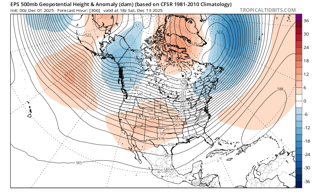
Yeah there is a nice trough in the east, but I see what to my layman's eyes looks like the dreaded AK vortex. Isn't that our signal to close the blinds for the following 3 weeks or so?
-
WxHawk - Southport is an interesting place with a lot of history...and good seafood! But I am happy to be out of the heat and humidity - much prefer the full 4 seasons and potential winter precip here in the NC Mtns.
-

First Winter Storm to kickoff 2025-26 Winter season
weatherwiz replied to Baroclinic Zone's topic in New England
Overall profile is a bit toowarm but GFS bufkit does flip BOS to a couple hour period of heavy snow during the evening on the backside...even drops a quick inch or two. -

First Winter Storm to kickoff 2025-26 Winter season
ORH_wxman replied to Baroclinic Zone's topic in New England
It’s def had a cold bias in the medium range the last few years. It especially does when we’re talking these SWFE or WAA type storms. The old euro actually had a slight warm bias in the medium range but it was still the best model by a lot. -
First Winter Storm to kickoff 2025-26 Winter season
HoarfrostHubb replied to Baroclinic Zone's topic in New England
The flash freeze will be fun -

First Winter Storm to kickoff 2025-26 Winter season
WxWatcher007 replied to Baroclinic Zone's topic in New England
Imo it’s only a win if there’s measurable, so that costing better be decent. But yeah, at least we have something, and a decent pattern actually taking shape. Early December is hard with a retreating high. -
A little strung out on the Euro and flat but objectively hilarious to see it show snow just as other models fall off the wagon.
-
BlueRidge...yes, I am right next to BW Mtn..the peak is about 1.5 mile hike/700 ft up from my house. I have mined the Bearwallow Econet station for much data to prepare for winters here. Elsewhere, I was there in Montclair VA (P William Co) for that amazing winter of 2010-11. I think I totaled up approximtly 85" of snow that winter. I worked with several USN METOC officers as part of Joint ops while on AD, and then while working as GS civ service employee for Dept of AF Weather. Traveled to both Monterey (NPS) adn Stennis during that time, among other trips
-

First Winter Storm to kickoff 2025-26 Winter season
Typhoon Tip replied to Baroclinic Zone's topic in New England
Nah... we're getting gypped late, and as is typical ... that is when the models put out a menagerie of bum pump near misses and if onlys. -
First Winter Storm to kickoff 2025-26 Winter season
ORH_wxman replied to Baroclinic Zone's topic in New England
One more tick warmer and the evening commute will be fine too across even interior SNE north of pike. -
Weird evolution there. Probably some different looks coming with that if there is something for Friday/Saturday
-

First Winter Storm to kickoff 2025-26 Winter season
SouthCoastMA replied to Baroclinic Zone's topic in New England
We've seen this scenario time and again the past several winters. The euro being the coldest solution/outlier 3-4 days out then slowly trends to other guidance, It could be anecdotal but just seems to have a cold bias up here in that mid range. In the past it wouldn't budge much while the other models trend much colder. Its just my perception, and may not reflect its overall ability, or even reality. -
First Winter Storm to kickoff 2025-26 Winter season
ORH_wxman replied to Baroclinic Zone's topic in New England
Yeah that’s further SE than pivotal by a decent amount. Sv is awful. -
Yeah overall cold but I don't like seeing those low heights over Alaska ak vortex.

-
Euro with a little hope Friday morning?
.thumb.png.1b6b1df5bb77016bbfe7672bd0bcd0ca.png)


.png.a7f8facd1ef6f676b97a5b931924a756.png)