All Activity
- Past hour
-
I expect another baseline temperature jump this year. The amount of heat release in the pacific is going to be astronomical. The cpac hurricane and Epac typhoon seasons should be historic. .
-
Today’s Boston Globe has a good article about the May 1977 snowstorm. here’s the link, but I’m pretty sure it’s probably paywalled: https://www.bostonglobe.com/2026/05/09/metro/mothers-day-snow-storm-1977-ma/
-

Central PA Spring 2026 Discussion/Obs Thread
mahantango#1 replied to Voyager's topic in Upstate New York/Pennsylvania
-
Records: Highs: EWR: 93 (2000) NYC: 94 (1979) LGA: 92 (2000) JFK: 86 (2000) Lows: EWR: 33 (1947) NYC: 34 (2020) LGA: 36 (2020) JFK: 34 (2020) Historical: 1894: Portland, OR had its latest freeze when the temperature fell to 32°. This is the only May freeze in Portland's history. 1918: An F4 tornado moved across Floyd, Chickasaw, and Winneshiek Counties in northeast Iowa from two miles north of Pearl Rock to Calmar. Two people died just east of Calmar, when the tornado was a mile wide. Losses in and near Calmar totaled $250,000. Overall, this tornado killed 7 people and injured 15 others. An F3 tornado initially touched down a mile south of Pachard, IA then moved east northeast into Chickasaw County, Iowa and dissipated three miles east of Pearl Rock. A woman was killed there when a dozen homes were damaged. As many as 30 people hid in a single cellar. Overall, it killed one person, injured 5 other, and caused $50,000 dollars in property damage. (Ref. Wilson Wx. History) 1922: Yosemite Valley, CA received 7.5 inches of snow, their biggest May snowfall on record. (Ref. Wilson Wx. History) 1923: TRACE OF SNOW FELL AT WBO AND BAL. 1927: A major tornado outbreak occurred from Texas to Michigan. There were 28 tornadoes rated F2 or greater. Nine separate tornadoes killed five or more people. A tornado touched down 5 miles east of Morrisonville, IL, then moved northeast to Decatur. In Christian County, the tornado killed one person and caused 67 injuries. The tornado widened in the Decatur area, did minor damage to over 1,000 homes, and injured 50 people. Popular Bluff, MO was devastated by an F4 tornado. 98 people were killed and 300 were injured. 31 business and residential blocks were destroyed in the city. Strong, AR was leveled by another F4 tornado with 24 people killed. St. Louis, MO reported a wind gust of 75 mph. Behind the storm, Chadron, NE reported two inches of snow. (Ref. Wilson Wx. History) 1933: A tornado causing F4 damage moved through Monroe, Cumberland, and Russell Counties in Kentucky along a 60-mile path. The town of Tompkinsville, KY was the hardest hit with 18 people killed. Overall, 36 people lost their lives. (Ref. Wilson Wx. History) 1959: An outbreak of tornadoes occurred in central and eastern Oklahoma with more than 10 tornadoes. The most significant tornado, an F4, touched down near Harden City in Pontotoc County, and produced a path of devastation before lifting north of Stonewall. Seven people were killed and another 12 injured by the twister. Many head of cattle were killed and 20 oil derricks north of Harden City were destroyed. (Ref. Wilson Wx. History) 1966 - Record snows fell in the northeastern Ohio and western Pennsylvania, including 3.1 inches at Pittsburgh PA and 5.4 inches at Youngstown OH. Snow also extended across parts of New York State, with eight inches reported in the southern Adirondacks. (The Weather Channel) 1977 - A late season snowstorm hit parts of Pennsylvania, New York State, and southern and central New England. Heavier snowfall totals included 27 inches at Slide Mountain NY and 20 inches at Norwalk CT. At Boston it was the first May snow in 107 years of records. The heavy wet snow caused extensive damage to trees and power lines. The homes of half a million persons were without power following the storm. (9th-10th) (David Ludlum) (The Weather Channel) 1979: A heat wave occurred across the east coast: Notable afternoon highs included 95° at Boston, MA and 94° at New York City. (Ref. Wilson Wx. History) 1985 - Lightning struck some trees about 150 yards away from a home in Alabama, and followed the driveway to the home. The charge went through the house and burned all the electrical outlets, ruined appliances, and blasted a hole in the concrete floor of the basement. (The Weather Channel) 1987 - Unseasonably warm weather spread from the Pacific Northwest to the Upper Mississippi Valley. Fifteen cities reported record high temperatures for the date. It was the fourth day of record warmth for Eugene OR and Salem OR. (The National Weather Summary) 1988 - A massive cyclone in the central U.S. produced severe thunderstorms from eastern Texas to the Upper Ohio Valley. A strong (F-3) tornado ripped through Middleboro KY causing more than 22 million dollars damage. Thunderstorms in east central Texas produced hail three and a half inches in diameter at Groesbeck, and near Fairfield. (The National Weather Summary) (Storm Data) 1989 - Thunderstorms developing ahead of a cold front in the south central U.S. produced golf ball size hail and wind gusts to 62 mph at Mira LA, and during the morning hours drenched Stuttgart AR with five inches of rain. (The National Weather Summary) (Storm Data) 1990 - Thunderstorms produced severe weather in the central U.S. during the evening hours, mainly from southeastern Missouri to southwestern Indiana. Severe thunderstorms spawned four tornadoes, including two strong (F-2) tornadoes in southern Illinois. Strong thunderstorm winds gusted to 85 mph at Orient IL, and to 100 mph at West Salem. Thunderstorms drenched northeastern Illinois with up to 4.50 inches of rain. (The National Weather Summary) (Storm Data) 1995: A 7-year-old girl was killed when a lightning bolt directly struck her as she played softball in a park at Lighthouse Point in Broward County, Florida. The thunderstorm was about 5 miles northwest of the park when the lightning struck in the midst of 10 children and coaches. The park is surrounded by trees. (Ref. Wilson Wx. History)
-
Very strong waterspout showing up on radar off ocracoke right now.
-
58 / 48 clouds and scattered showers. The first of what will be 4 or 5 of the next 7 days cooler/ cloudy and some lighter rain . showers today with some nicer or partial niver days mixed in Sunday - Tuesday as trough and sort of a cut off ULL move through this week. By next weekend we should moderate towards and above normal with next show at some more persistent warmth >80 5/17 - 5/24 and beyond.
-
Step out week ... More apt to call it a 'leap' actually wrt to seasonal migration occurs later this next week in all three popular operational versions. The ambient non hydrostatic heights are ending up elevated, post trough transits. This was not as coherent a behavior over prior weeks so I'm considering that as the next threshold-significant move. And it doesn't take till the 20th of the month either. The modulation actually begins 13th..15th. In fact, the overnight GFS run subtly ends up with a static 582 dm height contour aligning roughly IND-BOS, positioning the mean polar jet clearly N of the conus for multiple days beyond. The 06z tries to even heat wave prior to what's likely a faux default erosion out there at 320+.
-

Central PA Spring 2026 Discussion/Obs Thread
Voyager replied to Voyager's topic in Upstate New York/Pennsylvania
Yup. It's getting quite old... And yet ANOTHER semi crappy weekend day today. Chilly, damp and drizzly. -
Ugh
-
I can only hope
-
rain coming in a little sooner then expected this morning..
-
Is it possible that May will be cooler than April?
-

2026-2027 Strong/Super El Nino
snowman19 replied to Stormchaserchuck1's topic in Weather Forecasting and Discussion
-
When does construction of the bear run begin?
- Today
-

Central PA Spring 2026 Discussion/Obs Thread
pawatch replied to Voyager's topic in Upstate New York/Pennsylvania
50 degrees and rain. .10” today so far. kicking around firing up the coal stove again. Supposed to be in the 30’s Monday morning. NWS on daily description: Rain then rain likely -
2026-2027 Strong/Super El Nino
snowman19 replied to Stormchaserchuck1's topic in Weather Forecasting and Discussion
Agree. We are very likely to be into a super El Niño (over +2.0C) by September, if not August -
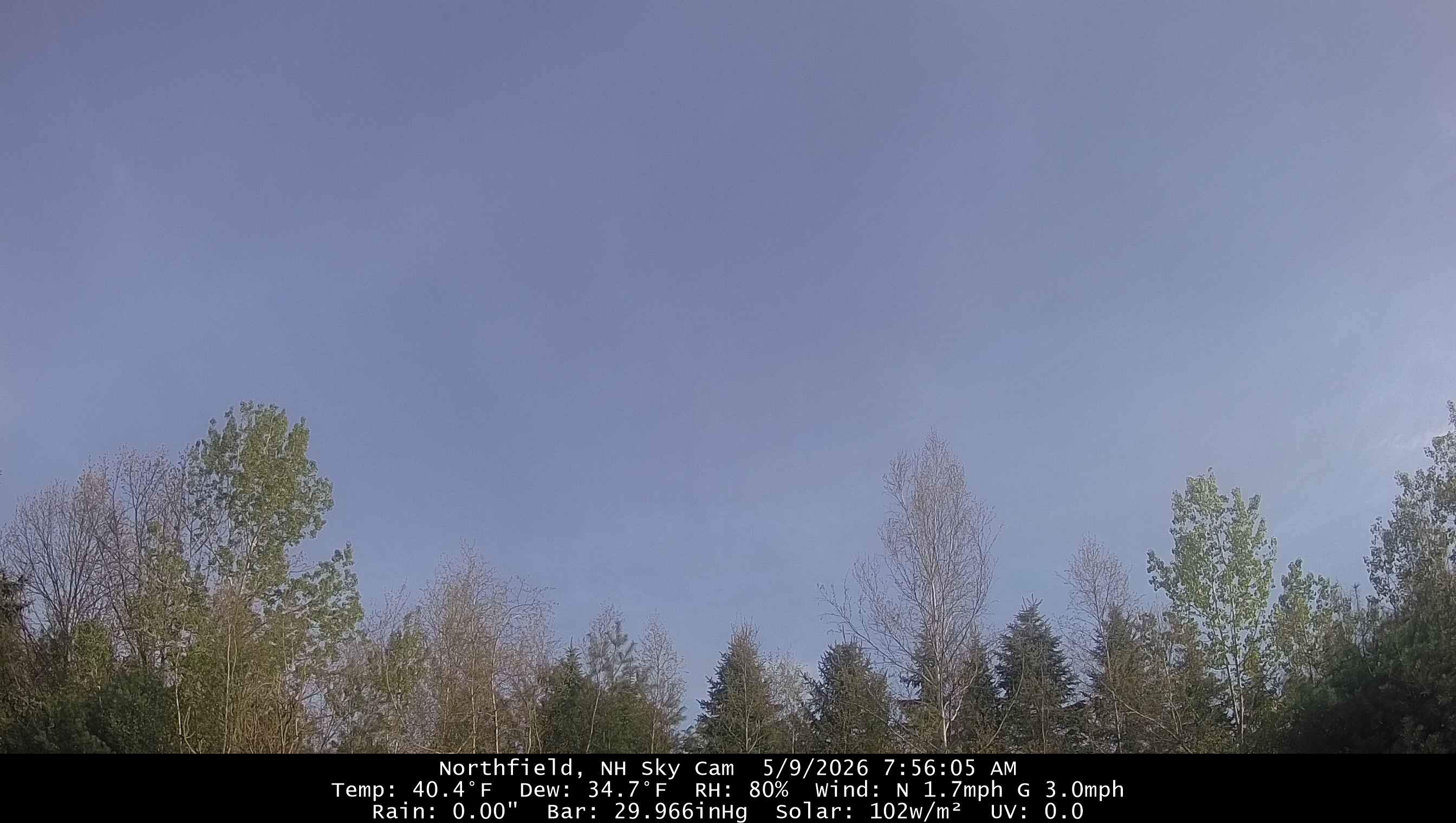
Nice morning. We sun for now.

-

Central PA Spring 2026 Discussion/Obs Thread
Mount Joy Snowman replied to Voyager's topic in Upstate New York/Pennsylvania
Low of 53. Looks like the rain should hold off just enough to get in our son’s 9am baseball game. -
Nice hot pattern shown there. You really are struggling
-
AN heights and BN precip. Sweet.
-

Winter 25-26 (All Snowfall Maps & Season Total)
The 4 Seasons replied to The 4 Seasons's topic in New England
yea i closed that gap of 36-48 from the last update on March 2nd. There was nothing under 48" from cocorahs stations but if you're right at 48 thats probably a min nearly statewide except for the cape/ACK -
Winter 25-26 (All Snowfall Maps & Season Total)
The 4 Seasons replied to The 4 Seasons's topic in New England
I wish there were some spotters in the upper elbow. It would help me know what to do there when there is a tight gradient. I rarely, if ever, see reports from Provincetown... -
Summer of 1816 incoming.
-
Another windy ass day on tap
-
Dandelions are blooming. Making sure I let them flower and spread their seed this year like tblizz.