All Activity
- Past hour
-
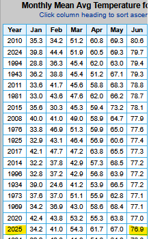
MDT's summer records start in 1992. That means, including this year, there are 34 years of summer records. Assuming your calculation is correct, a "top 20th warmth" is just like saying the 14th coolest. So why didn't you say it like that? I think you made my point.
-

2025 Atlantic Hurricane Season
BarryStantonGBP replied to BarryStantonGBP's topic in Tropical Headquarters
LMAOOOOOOO -
But let me tell you I got some news for you, And you'll soon find out it's true... She's already gone. Woo hoo hoo woo hoo hoo
-
Rain! Had more than expected, with 0.47" just before sunset and another 0.27" between 10:30-11 PM. August total is now 1.02" and met summer 4.99". Driest met summer thru 2024 is 7.24" in 2002. That record is toast. (Max is 23.82" in 2009.)
-
 Yea I think this stuff about low sun angle heat not feeling bad is pure cope. Hot is hot, and anything above 85 is way too hot. I'd be surprised if we dont roast come mid September as payback for this nice August
 -
Not the nice part of Autumn though, perpetual November. Heating bills and no snow.
-
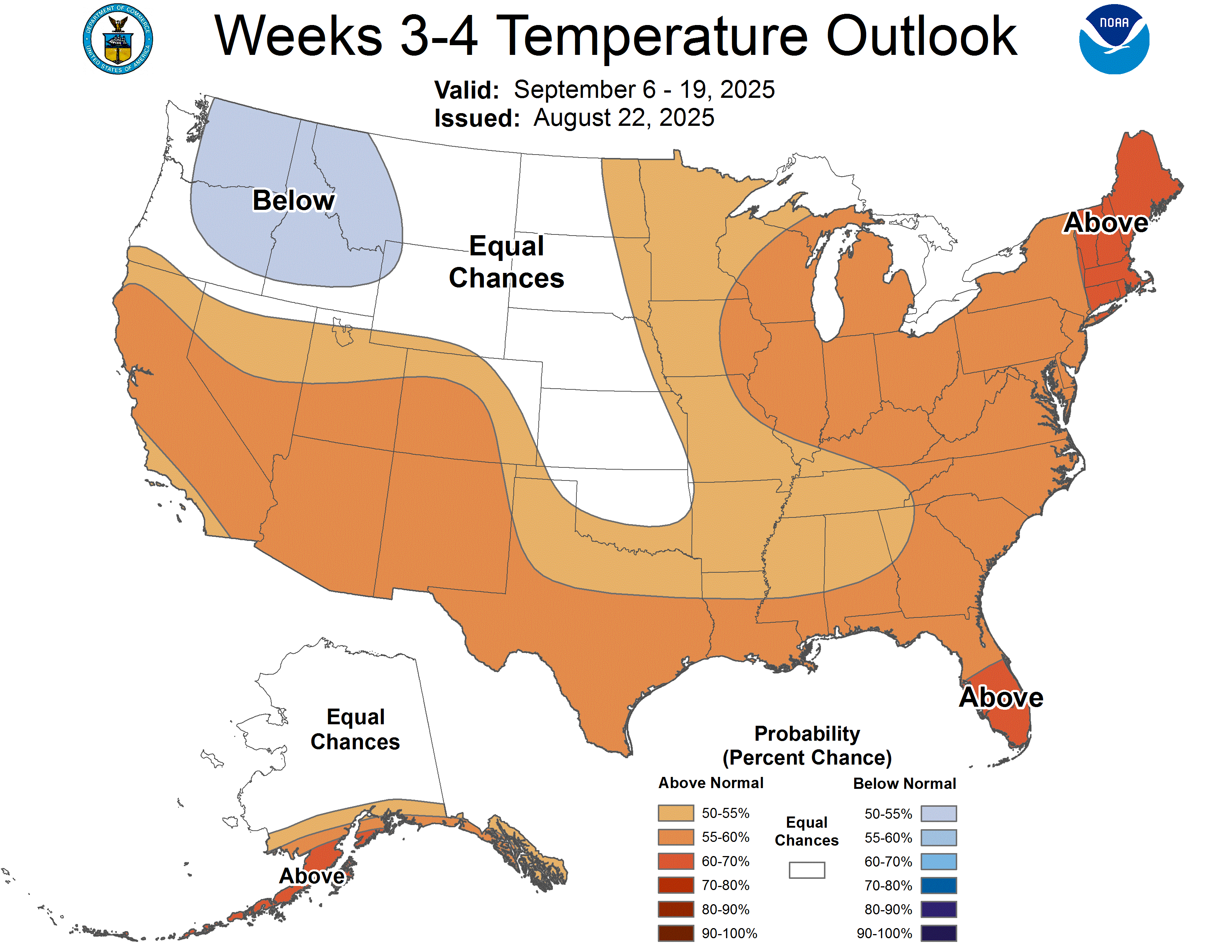
Looks like we warm back up after this cooler stretch of weather.

-
This 100%. We never get cool downs "for free". It's always one slightly below normal month followed by 2-3 blowtorches right after. I'm expecting a torchy fall.
-
“Highlights • The PMM index defined in this study removes the signals of ENSO more effectively. • A positive PMM is weakly related to El Niño, while a negative PMM is more convincingly related to La Niña.” https://www.sciencedirect.com/science/article/abs/pii/S0169809524000917
-
 Records: Highs: EWR: 103 (1948) NYC: 103 (1948) LGA: 103 (1948) JFK: 100 (1948) Lows: EWR: 51 (1942) NYC: 53 (1887) LGA: 53 (1940) JFK: 53 (1963) Historical: 1591: Roanoke Island was again struck by a severe storm. The winds blew out of the northeast, directly into the harbor. Waves crashed on a sandbar and currents in the area became quite dangerous. (Ref. for the storm of 1591) 1635: New England on August 25th and 26th: The Great Colonial Hurricane strikes the New England coast. Rev. Increase Mather writes: "...no storm more dismal than the great hurricane." Many shipwrecks and several near-disasters occur during the storm, one of which would give birth to a favorite New England legend surrounding Thacher's Island. (Ref. WxDoctor) 1827: A hurricane originating near the Windward Islands struck Cape Hatteras, before moving northeast offshore Virginia, Maryland, and New England. Initial reports from Wilmington, NC indicated that this was a storm of great intensity as it passed by to their east. One report gave an account of waves over the top of garden fences some 6900 feet from the beach. Other reports indicated storm tides greater than 10 feet above normal levels. The western end of Pamlico Sound, reported water levels 12 to 15 feet above ordinary levels. The following first hand account of this storm in Virginia was from the Tazewell Papers in the Virginia State Library. Henry Tazewell wrote to his brother John in New York and described the storm as such. "....A severe gale which continued for three days changed the climate here entirely and persons are clad generally in full suits of winter clothing; the same gale has done great injury to shipping and to present crops. The fodder is worthless and the corn in many places is much broken by the wind." The gale "...commenced in the forenoon of August 25th and continued to increase until the evening, when it blew tremendously. About midnight, the rain ceased and the gales somewhat abated, though it continued to blow fresh all day on the 26th." At the height of the storm, winds unroofed a two story building on Talbot street in Norfolk and commenced to blow away the second floor of the building. Livestock was swept away in large numbers. Corn was leveled at Belleview...a mill dam was torn to shreds and the bridge over it was swept away. (Ref. for St. Kitts Hurricane) 1864 - A train running from Cincinnati to Chicago was derailed by a tornado in Dearborn County, Indiana, or 75 miles southeast of Indianapolis. Two passenger cars were lifted from the tracks and dropped in a ravine which injured 30 people. 1883 - Krakatoa Volcano exploded in the East Indies. The explosion was heard more than 2500 miles away, and every barograph around the world recorded the passage of the air wave, up to seven times. Giant waves, 125 feet high and traveling 300 mph, devastated everything in their path, hurling ashore coral blocks weighing up to 900 tons, and killing more than 36,000 persons. Volcanic ash was carried around the globe in thirteen days producing blue and green suns in the tropics, and then vivid red sunsets in higher latitudes. The temperature of the earth was lowered one degree for the next two years, finally recovering to normal by 1888. (David Ludlum) 1895: Snow flurries affected parts of Pennsylvania, New York and New England with snow observed as far south as Hartford, CT. (Ref. Wilson Wx. History) 1910: Peoria, IL registered a low temperature of 41°. This established a record for the month of August, although it has been tied twice since then. Daily low temperatures were established at Lincoln, IL with 37°; Decatur, IL: 44°; and Champaign, IL: 46°. (Ref. Wilson Wx. History) 1915: Severe cold and killing frosts across Minnesota with 23 degrees at Roseau, MN. (Ref. AccWeather Weather History) 1924: A hurricane brushed New England with 80 mph winds reported at Blue Hill Observatory in Milton, MA. The pressure at Nantucket Island dropped to 28.71 inches of mercury. Boston, Massachusetts recorded its lowest pressure 29.26 inches of mercury for the month of August. (Ref. NOAA Boston Weather Events) 1940: Boston, Massachusetts had its lowest August temperature of 46 °F. (Ref. NOAA Boston Weather Events) 1949 - A hurricane made landfall at Delray Beach. Winds reached 153 mph at the Jupiter Lighthouse before the anemometer failed. The hurricane caused 45 million dollars damage to crops, and also caught the Georgia and South Carolina coast resulting in another two million dollars damage. (David Ludlum) 1965 - Late night severe thunderstorms associated with an unusually strong late summer cold front produced 100 mph winds straight line winds in the Chicago area and northwest Indiana. In Lake County IND, high winds derailed a train near Crown Point, and left a canoe suspended among telephone lines. Two nights later the temperature at Midway Airport in Chicago dipped to 43 degrees, establishing a record for the month of August. (Storm Data) (Hugh Crowther) 1976 - A weak tornado touched down briefly in the Hockley Hills near Kiana, AK, about 29 miles north of the Arctic Circle. (The Weather Channel) 1987 - Showers and thunderstorms drenched northern Illinois during the morning and afternoon hours pushing August rainfall totals for Chicago, Moline and Peoria to new all-time highs for any month of the year. By the end of August, Chicago had received 17.10 inches of rain, which easily surpassed the previous record of 14.17 inches established in September 1961. (The National Weather Summary) 1988 - A dozen cities in Texas, Colorado and California reported record high temperatures for the date, including readings of 100 degrees at Pueblo CO, 106 degrees at Wichita Falls TX, and 109 degrees at Redding CA. Afternoon thunderstorms in Utah deluged the town of Beaver with more than an inch of rain in twenty minutes. (The National Weather Summary) 1989 - Anchorage, AK, was soaked with a steady rain, and the 24 hour total of 4.12 inches smashed their previous 24 hour precipitation total of 2.10 inches. It also pushed their rainfall total for the month past their previous record for August. (The National Weather Summary) 1993: Butte, MT picked up 5 inches of heavy, early season snow. (Ref. AccWeather Weather History) 1996: Norfolk, VA lightning seriously injured two boys who were sitting at a picnic table beneath a tree. (Ref. Lightning - Virginia Weather History) 2002: No tornado damage, just high straight-line winds. Severe thunderstorm winds to 87 mph overturned 15 empty railroad cars in Wallace, KS; each had a posted weight of 15 tons. (Weather Guide Calendar with Phenomenal Weather Events 2011 Accord Pub. 2010, USA) A severe thunderstorm produced large and damaging hail at Cheyenne, WY during the evening. Hail up to the size of baseballs fell over especially the central and west parts of town producing widespread damage, particularly to roofs and automobiles. Total damage estimates exceeded $30 million dollars. (Ref. WxDoctor) 2003: A derecho associated with a cluster of severe thunderstorms affected parts of Michigan and states eastward to Washington, DC. Strong winds left hundreds of thousands of customers without power, just weeks after the Great Blackout of 2003. The Great Blackout of 2003 was Thursday, August 14, 2003, just before 4:10 p.m. EDT. At the time, it was the second most widespread blackout in history, after the 1999 Southern Brazil blackout. (Ref. Wilson Wx. History) 2005: Katrina made landfall in southern Florida on August 26 as a Cat 1 hurricane. It crossed Florida and headed through the Gulf of Mexico, growing in strength to a Cat 5 while still offshore of Louisiana on August 28, with top wind speeds of 175 MPH and a central pressure of 902 MB. Fortunately before making landfall on August 29 in Eastern Louisiana/southern Mississippi it diminished somewhat in intensity to a Cat 3. There were 1833 deaths and $81 billion in damages, the costliest hurricane ever in the United States. Ref. (Weather Underground Hurricane History Archives - Katrina) Also see -- Complete History of Hurricane Katrina 43 pages Katrina made landfall again see the date - (August 29, 2005) for more information. 2007: The remnants of Hurricane Dean produced thunderstorms and heavy rain all over the San Diego Metro area in southern California. Two inches of rain fell in just 90 minutes at Escondido during the morning. (Ref. Wilson Wx. History) 2017: Harvey's intensification phase stalled slightly overnight from August 24–25, however Harvey soon resumed strengthening and became a Category 4 hurricane late on August 25. Hours later, Harvey made landfall near Rockport, Texas, at peak intensity. The strongest winds were focused just northeast of Corpus Christi, around Rockport. The highest reading of 132 mph was registered at Port Aransas. Harvey, a tropical storm by Tuesday morning with its eye hovering over the Gulf of Mexico, could still dump up to 15 inches of rain on portions of southeastern Texas and southwestern Louisiana, including the saturated Houston area, where thousands have been rescued and many more still wait for help. The greatest problem would be the record rainfall amounts. (15 inches of rain and more to come) (Harvey made landfall near Rockport, Texas)(Satellite-before-Landfall on the 24-25 landfall near Rockport, Texas) 2020: Wednesday- August 26 -2020 Nearing landfall, Laura reached peak intensity as a category 4 hurricane early Wednesday evening as a NOAA hurricane hunter aircraft indicated that maximum sustained winds had increased to 150 mph as the center of Laura was approximately 120 miles to the south of Lake Charles, LA. as the central minimum pressure fell to 937 mb ( inches of mercury). At that time, Laura's outer bands had begun moving onshore along the Louisiana coast, accompanied by strong winds, steady rain and several possible tornadoes. Hurricane Laura made landfall along the Louisiana Gulf Coast near Cameron, LA just after midnight on
 -
LOL at using hot button terms like agenda, shocked, and appalled. Try taking a step back and just looking at the actual data instead putting a strong emotional charge on it. Your area is further south than where the strongest Northeast warmth has occurred this summer. MDT is currently at an average summer temperature of 75.9°. That is the 13th warmest average summer temperature. You guys should slip back several spots with the cooler pattern to close out the summer. The current departure is only +0.7°. So the actual summer will finish up with top 20 warmth even if the departure isn’t that high.
-
 You'd be surprised. I remember the mid 90s in October 2019 and it felt hot as hell despite the lower Sun. The Sun angle on the September Equinox at solar noon is about the same as the June solstice Sun angle at 4PM.
 -
Philly has double digit more 90 degree days (17!) than Trenton which is only 30 or so miles away. Their highs have been off according to even Mets on another Philly centric board.
- Today
-
 Agree, and hit no traffic for once. 56 here. Decent amount of 50s (even some lower 50s) this month with several more to come
 -
68 / 51. Overall nice stretch of dry weather the next week. Only chance of rain remains Wed late / Thu but seems to be dry. Temps near / below normal the next week Upper 70s / low 80s for the most part of NYC/NJ/LI. Trough remains through the first / Second before some moderation towards warmer by the 3/rd / 4th and beyond.
-
More from DCA..... June...18th hottest July....10th hottest: DCA only. I would guess the others would be a bit hotter. Low of 55 this morning here in the swamps of Anne Arundel
-
I am using current climate numbers to determine above or below normal just as previous NWS records established above or below normal readings. That's their protocol. If you want to cherry pick by using or considering different periods to push an agenda, that's fine. But don't be shocked or appalled when someone else points out that's what you're doing. Like it or not, the numbers I posted for MDT are what will be used by the NWS.
-
Heh. They’re finally disappearing here
-
Looks like today might actually be sunny unlike yesterday’s sunny that came with a fair share of clouds. I’m all in.
-
64 for the low this morning! Currently 69 and feels incredible out
-
Yeah I'd be alright with this weather for the next 6 weeks, with the occasional rain chance so we don't dry out.
-
Parkton Mesonet got down to 47
-

2025-2026 ENSO
PhiEaglesfan712 replied to 40/70 Benchmark's topic in Weather Forecasting and Discussion
PHL June 75.4 (+2.2 1981-2020; +1.9 1991-2020) July 81.9 (+3.8 1981-2020; +3.2 1991-2020) August so far is 76.0 (-1.2 on the 1991-2020 average). It looks like we'll end the month with 23 below average days, 7 above average days, and one on the average. Very good chance we finish with our coldest August since 2014, and an outside chance (if we fall below 74.6) the coldest since 2000. -
Just waiting for the skeeters to start appearing. September is usually rough down here.
-
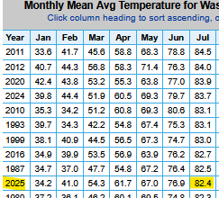
What’s with you guys and the term agenda. Last time I checked thermometers didn’t have agendas. BTV is currently only +1.9 for the summer and they are tied for warmest summer on record. So it takes a smaller warm departure for record warmth when the current climate normals period is so warm. Time Series Summary for Burlington Area, VT (ThreadEx) top 10 warmest summers dense rank sorting for temperature Click column heading to sort ascending, click again to sort descending. 1 2025 72.3 6 - 2020 72.3 0 2 1949 72.2 0 3 2024 72.1 0 - 2018 72.1 0 4 2021 71.9 0 5 2005 71.5 0 6 2016 71.4 0 - 1995 71.4 0 7 1901 71.2 0 8 2022 71.0 0 - 1899 71.0 0 9 2012 70.9 0 - 1999 70.9 0 - 1895 70.9 0 10 1900 70.8 0


.thumb.png.4150b06c63a21f61052e47a612bf1818.png)