All Activity
- Past hour
-

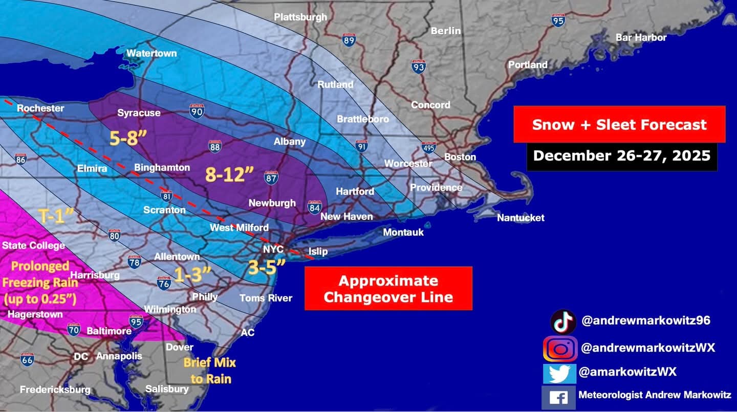
26th-27th event, coming at us like a wounded duck.
Sey-Mour Snow replied to Go Kart Mozart's topic in New England
Yessir! Congrats up north! Hopefully an even better distribution for all. -
Accu weather has my Brooklyn neighborhood down to 28 while Central Park is 29 at 23:51. A 20 degree drop in 9 hours from the 49 degree reading at 14:51.. as always ….
-

26th-27th event, coming at us like a wounded duck.
Snowcrazed71 replied to Go Kart Mozart's topic in New England
?... Still shifting north I take it. -

Central PA Winter 25/26 Discussion and Obs
Itstrainingtime replied to MAG5035's topic in Upstate New York/Pennsylvania
Problem is...there aren't many Eric Horsts to be found. We were so fortunate to have him, and you can attest to that first hand. -
I mean,Dec should even break Dec records for EQBO
-
yeah, would angle it more NW-SE than that map implies
-

26th-27th event, coming at us like a wounded duck.
OrangeCTWX replied to Go Kart Mozart's topic in New England
Still lean 3-6 here given how quick this thing moves through but fingers crossed we get 6+. I heavily hinted to the wife that getting a new snow blower would be a great Christmas investment as our current one is having issues. That did not happen. At least this shouldn’t be a heavy wet snow to shovel lol -
Someone gonna get buried. In 24 hours we'll know who. Best chance is OC north of 17/84, but not ruling out on LI.
-
.thumb.png.4150b06c63a21f61052e47a612bf1818.png)
26th-27th event, coming at us like a wounded duck.
HIPPYVALLEY replied to Go Kart Mozart's topic in New England
I will boldly venture a "yes" response on that, if it looks like the potential for 6"+ was imminent... -
Just walked the dog,,,,,23 degrees here in New City = that is all
-
26th-27th event, coming at us like a wounded duck.
Snowcrazed71 replied to Go Kart Mozart's topic in New England
I wonder... Would they actually upgrade the Winter weather advisory in Hartford to a winter storm warning? -
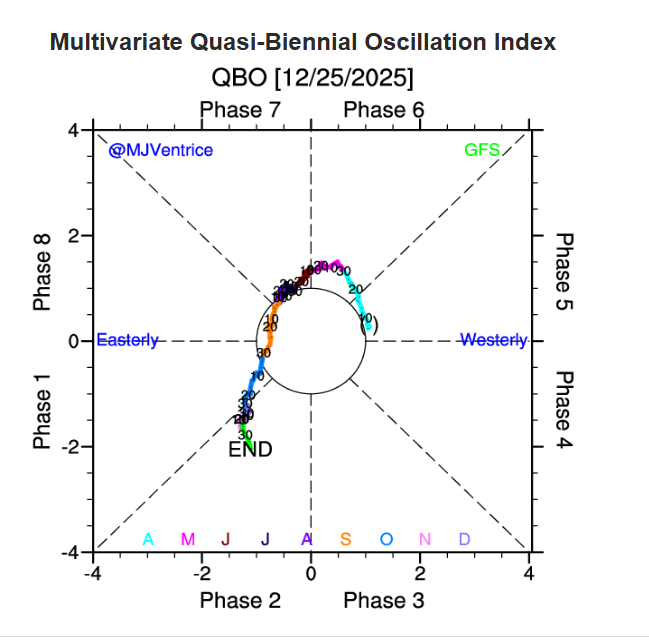
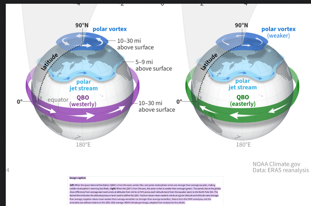
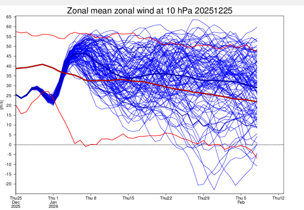
This might be one of the most negative EQBO since we've seen into the early 40's into Jan,tho its still up in the air right now https://psl.noaa.gov/data/correlation/qbo.data
-
I actually think BGM is more likely to mix with sleet than western LI as crazy as that sounds... because of the track of the 700mb low. Otherwise I agree, good map.
-
Lowest map i have seen so far.
-
You will do good so pics please
-
Good map

-

Pittsburgh/Western PA WINTER ‘25/‘26
TheClimateChanger replied to Burghblizz's topic in Upstate New York/Pennsylvania
Some thunder possible tomorrow evening, not expected to be severe with MUCAPE below 500 J/kg. Although I do wonder if some small hail might be possible with any stronger cells, especially in the warm sector. ...Eastern Great Lakes to the Mid Atlantic... A secondary trough on the eastern periphery of the ridge will intensify as it moves out of the Great Lakes and into the Northeastern US late Friday into early Saturday. A modest surface low and low-level warm advection will allow for weak elevated destabilization and isolated storms over parts of eastern MI and OH, into the central Appalachians Friday evening. Buoyancy will become increasingly scant farther east into the Mid Atlantic. While a few storms remain possible into early Saturday, peak MUCAPE below 500 J/kg suggests severe potential is very low. -
Ukie bumped north
-
Looks like you all do good with this so that’s great for Holiday time. My grand children are old enough to sled finally and Santa delivered, You all have fun with yours!
-
Hrdps
.thumb.png.f6d835bc12e5e17b3bcb1c1d5679b026.png)
-
Knyc: 2.4” ewr: 4.2 lga: 3.1 hpn: 4.8 somewhere in the oc hinderlands: 10.7”
-
Hey I’m in NYC for this one
-
That 1033 high is now right on the nipple of Hudson/James Bay.
- Today
-
28. Should be one of those overcast days in the 20s where it smells like snow
-

December 2025 regional war/obs/disco thread
Typhoon Tip replied to Torch Tiger's topic in New England
You might be in luck … Major guard change signaled in the extended GEPS with coherent collapse of that remarkably persistent and intense -WPO, now being joined by the extended EPS. GEFs lag but I suspect it’s a matter of time …~ 10th+ of Jan This will send the roulette wheel for a turn … at least introducing footprints less neg interfering with the +PNA hemisphere … sorely lacking so far this cold season with that erstwhile signal - other than unstable quickly transient moments. 30th is a good example of this … That -WPO is an unusual/historic scenario and its sending odd wave signatures radically down stream. Need to get this inside of day 10 first


.png.bb061e1f0ba9306018d0944663a9a083.png)

