
All Activity
- Past hour
-
Be happy you’re getting rain out of this thing Friday night in ENE. Most of us Steining thru day 10 with no rains
-
Is there a product out there that can sort of calculate what the ambient pressure, outside of cyclone, is ? Like not every low pressure is as impressively deep as it may look in scalar, because the surrounding medium isn't appreciably high. The Feb 1978 blizzard "only" bottomed out at 992 or something - pedestrian by nor'easter cyclone depth climatology. But the 75mph sustained Boston Light winds pushing the surf into 30' seismic rollers would tend to argue that pressure well was somehow systemically deeper than 992, because the surrounding was elevated. I'm wondering for the 1003 mb low and the 50 mph wind frequent short duration ( like 4 hour window) nor'easter
-

2026-2027 Strong/Super El Nino
LakePaste25 replied to Stormchaserchuck1's topic in Weather Forecasting and Discussion
Pac jet came in stronger than expected in Feb 2024, which pushed the jet exit region well onshore over the western US. One of the few times we got true Nino forcing, we got too much of it. -
-
although maybe some cold pool storms early next week
-
86. Summer now, November by Saturday.
-
 It's looking like it's lasting a week max.
 -
Mostly sunny now…just some Ci 77.3°
-
Tornado warning east of Columbus OH.
-
Can't believe its looking like another dud for the first two weeks of June for my friend and I. We had done the final week of May and first week of June from like 2009 until like 2019 then didn't get together the covid year and then bumped to the first two weeks of June. We used to have pretty solid success until recently which is why we moved back a week. Well at least during my second week of vacation is when summer classes start so I guess I can use that to try and work ahead
-

2026-2027 Strong/Super El Nino
michsnowfreak replied to Stormchaserchuck1's topic in Weather Forecasting and Discussion
Exactly. The mean winter temp departures were very impressive considering it was all Dec/Feb. January was a decent winter month. -

Central PA Spring 2026 Discussion/Obs Thread
Superstorm replied to Voyager's topic in Upstate New York/Pennsylvania
Picked up 0.55” of rain so far today in Lancaster. Now 4.07” for month. . -
What a wonderful winter season it was.
-
I like the NAM gust 50 Saturday afternoon with attempts in the 40s. That’s cute.
-
Yeah, I hear ya, you hope we can get one of those 20 C 850 plumes from that direction. I’m not sure that’s the best direction for big heat not really a Sonoran heat connection but I suppose it’s possible. Probably will be a dry heat too. We shall see. Just not sold it on anything more than a day or two.
-
Looks like the warm front has been shoved south a bit. I'm thinking locations south of US 50 are probably better placed for afternoon convection?
-
 Perfect conditions for the 'brown heavy haze' to return if that locks in for a while.
 -
Approx 3/10” so far today imby/Columbia thru 11am.
-
Ha more rain. Much needed
-
Soupy out. DP up to 72
-
Love em.
-
Set a 'warm minimum' at 64.3 degrees, old mark was 63 from 1981. About 2.5" since the rain returned. Someone close by has gotten a good bit more, the river was up about 3 feet above normal and brown. 1st time I'll seen that in a while.
-

2026-2027 Strong/Super El Nino
40/70 Benchmark replied to Stormchaserchuck1's topic in Weather Forecasting and Discussion
Yea, I was thinking the same thing. That was supposed to be a mild winter that ended up even milder than expected. - Today
-
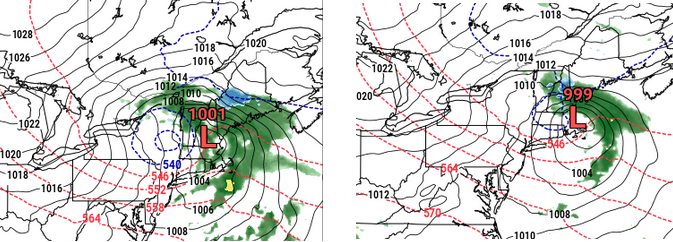
So earlier I intimated I suspected this thing this weekend might try to charlie brown the cold dweebs and their private/secret thinking that it's totally okay to snow at this time of year ... , by normalizing the metrics some as we move into the shorter range. In other words, it should correct to just insulting to us normal folk - While it is the NAM, and therefore ... probably not altogether very useful or trustworthy at this range, it is still showing some normalization in this 12z run... Left is the 00z 84 hour fantasy, the right in the 12z 72 hour ( same time), 12z Sat Clearly the right/more recent version is stepping off the cold enthusiast enabling throttle. Altho it's odd that the NAM pretty obviously dampens cyclogen thermodynamics and mechanics, while still making the low deeper...
-

E PA/NJ/DE Spring 2026 Obs/Discussion
The Iceman replied to PhiEaglesfan712's topic in Philadelphia Region
Every model was too far south with the precip today. Looks like southern PA on south should get at least another .25” today. Coming down at the moment here in Levittown and we had stuff come through overnight too for .15”.










.thumb.jpeg.f5c6ba9d911ec96b3b124f8606aee58e.jpeg)
