All Activity
- Past hour
-
Post obs and totals here. Good luck to all. Sone guesses: -Central Park 4.8", JFK 5.0", MMU: 4.2", HPN: 6.7", EWR: 4.0", ISP: 7.0", BDR: 7.3" New Brunswick: 2.8" Middletown NY: 7.5" Newburgh NY: 7.1" PHL 1.2" of crud, TTN: 1.6"-a little more snow but still mostly crud, ABE 2.1"
-

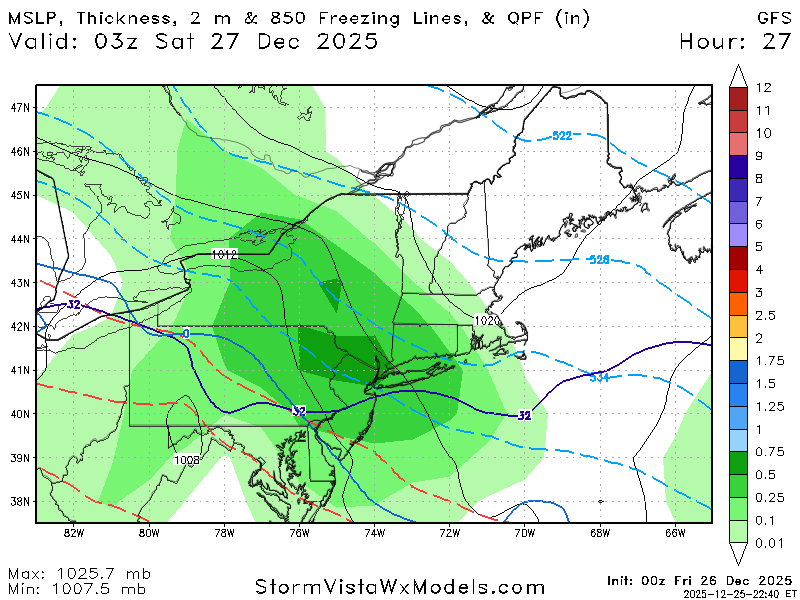
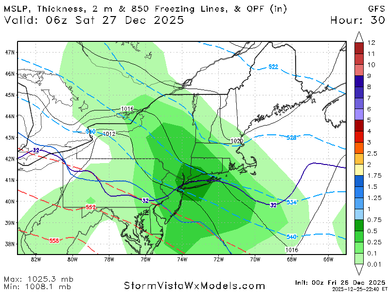
26th-27th event, coming at us like a wounded duck.
WinterWolf replied to Go Kart Mozart's topic in New England
Explain. -

26th-27th event, coming at us like a wounded duck.
WxWatcher007 replied to Go Kart Mozart's topic in New England
-
Maybe something around NYD
-
lee's pretty solid. i recommend him to the uneducated masses....news 12 guy is very good also.
-

December 2025 regional war/obs/disco thread
TauntonBlizzard2013 replied to Torch Tiger's topic in New England
After tomorrows deal, close the shades for a while -
More qpf
-
26th-27th event, coming at us like a wounded duck.
TauntonBlizzard2013 replied to Go Kart Mozart's topic in New England
Looks like gfs is going to tick north again through 24 -

26th-27th event, coming at us like a wounded duck.
Sey-Mour Snow replied to Go Kart Mozart's topic in New England
GFS says Merry Christmas -
GFS looks to Hold serve at 00z
-
Gfs is a big hit
-
I mean I guess I’ll settle for 2 10” storms instead of one 12”, if I must. Separately, isn’t the JMA a joke? Serious Q.
-

Central PA Winter 25/26 Discussion and Obs
canderson replied to MAG5035's topic in Upstate New York/Pennsylvania
He/she also needs an editor. -
Me too. Would rather take a train of small and medium sized events over one "big dog" that just blows the blocking apart in under a week. Snow on snow is always fun!
-
I think Lee Goldberg's is my favorite map so far, so I'll post it as my forecast, lol. I like that it's a little bit more aggressive than the NWS, which is now probably the low end of the predictions, but it's also below several others who have large 6-10"+ swaths which I think are too high. Lastly, time for my usual guess: I'll go with 6.1" vs. my NWS point and click of 5.7" and our advisory of only 3-5", which ought to be at least 3-6" for Middlesex County since there's a small 6"+ swath right near me in NE Middlesex Co.
-
High of 75 after a low of 38.
-
Brooklyn almost always goes to mix at the tail end of a storm when precip lightens. It has to be absolutely perfect for it not to happen. Southern most point along an Ocean and Bay in an UHI. Just geography and science at work.
-

26th-27th event, coming at us like a wounded duck.
UnitedWx replied to Go Kart Mozart's topic in New England
I have had too much adult eggnog and think I'm seeing double weenies! Didn't esspect to see this good a trend after the Christmas celebration -

Central PA Winter 25/26 Discussion and Obs
Eskimo Joe replied to MAG5035's topic in Upstate New York/Pennsylvania
Whoever runs the current MU weather account definitely has a "sunny and 75" bias. Eric Horst was good at keeping the social media accounts neutral during his time. -
.thumb.png.4150b06c63a21f61052e47a612bf1818.png)
26th-27th event, coming at us like a wounded duck.
HIPPYVALLEY replied to Go Kart Mozart's topic in New England
That was something I had not thought about or knew about. Interesting. Not really used to snows coming in at this trajectory but in my mind I was considering similar in precipitation shield to a SWFE. Meaning, it's a rare chance to be in a good zone of lift and decent precipitation here. -

2025-2026 ENSO
TheClimateChanger replied to 40/70 Benchmark's topic in Weather Forecasting and Discussion
I don't know. Tough to eyeball, especially with the different color schemes and the 2025 data not necessarily being maxT. Looks like California was several degrees warmer this year, so that would add to the population weighting, but the Ohio Valley and parts of the midwest were cooler. Certainly closer than an aerially-weighted comparison. -
Probably eyeing that warm nose as the low rushes into north Pa and Upstate New York. Would be all frozen precip for almost all of us, but a lot more sleet than it’s been showing
-
Too bad this snow (or sleet?) won’t last for long. Should melt within a few days, similar to the last one we had 2 weeks ago here
-

Central PA Winter 25/26 Discussion and Obs
Blizzard of 93 replied to MAG5035's topic in Upstate New York/Pennsylvania
CTP has no changes & just reissued this in the last hour… Winter Weather Advisory URGENT - WINTER WEATHER MESSAGE National Weather Service State College PA 951 PM EST Thu Dec 25 2025 PAZ006-011-012-018-019-025>028-034>037-041-042-045-046-049>053- 056>059-063>066-261800- /O.CON.KCTP.WW.Y.0027.251226T1700Z-251227T1200Z/ Potter-Cameron-Northern Clinton-Northern Centre-Southern Centre- Blair-Huntingdon-Mifflin-Juniata-Bedford-Fulton-Franklin-Tioga- Northern Lycoming-Sullivan-Southern Clinton-Southern Lycoming- Union-Snyder-Montour-Northumberland-Columbia-Perry-Dauphin- Schuylkill-Lebanon-Cumberland-Adams-York-Lancaster- Including the cities of Williamsport, Mifflintown, Pottsville, Lock Haven, Newport, York, Danville, Lebanon, State College, Altoona, Emporium, Berwick, Coudersport, Philipsburg, Wellsboro, Huntingdon, Chambersburg, Lewisburg, Mansfield, Carlisle, Lancaster, Lewistown, Shamokin, Sunbury, Hershey, Bloomsburg, Gettysburg, Mount Union, Bedford, Trout Run, Laporte, Harrisburg, Renovo, Selinsgrove, and McConnellsburg 951 PM EST Thu Dec 25 2025 ...WINTER WEATHER ADVISORY REMAINS IN EFFECT FROM NOON FRIDAY TO 7 AM EST SATURDAY... * WHAT...Mixed precipitation expected. Total snow and sleet accumulations up to two inches and ice accumulations up to two tenths of an inch. * WHERE...Most of central Pennsylvania. * WHEN...From noon Friday to 7 AM EST Saturday. * IMPACTS...Plan on slippery road conditions. The hazardous conditions will impact the Friday evening commute. * ADDITIONAL DETAILS...Much of the precipitation could fall as sleet. Sleet and freezing rain can both be dangerous, especially on bridges and sidewalks. They can also weigh down tree limbs and power lines. Power outages are possible. -
Central PA Winter 25/26 Discussion and Obs
Blizzard of 93 replied to MAG5035's topic in Upstate New York/Pennsylvania
Lol, with temps in the 20s & at least .3 of precipitation on the way…? Maybe it will be 80 tomorrow & we can jump in a swimming pool too?


