All Activity
- Past hour
-
Even warmer than the previous record at this time back in 2022.
-
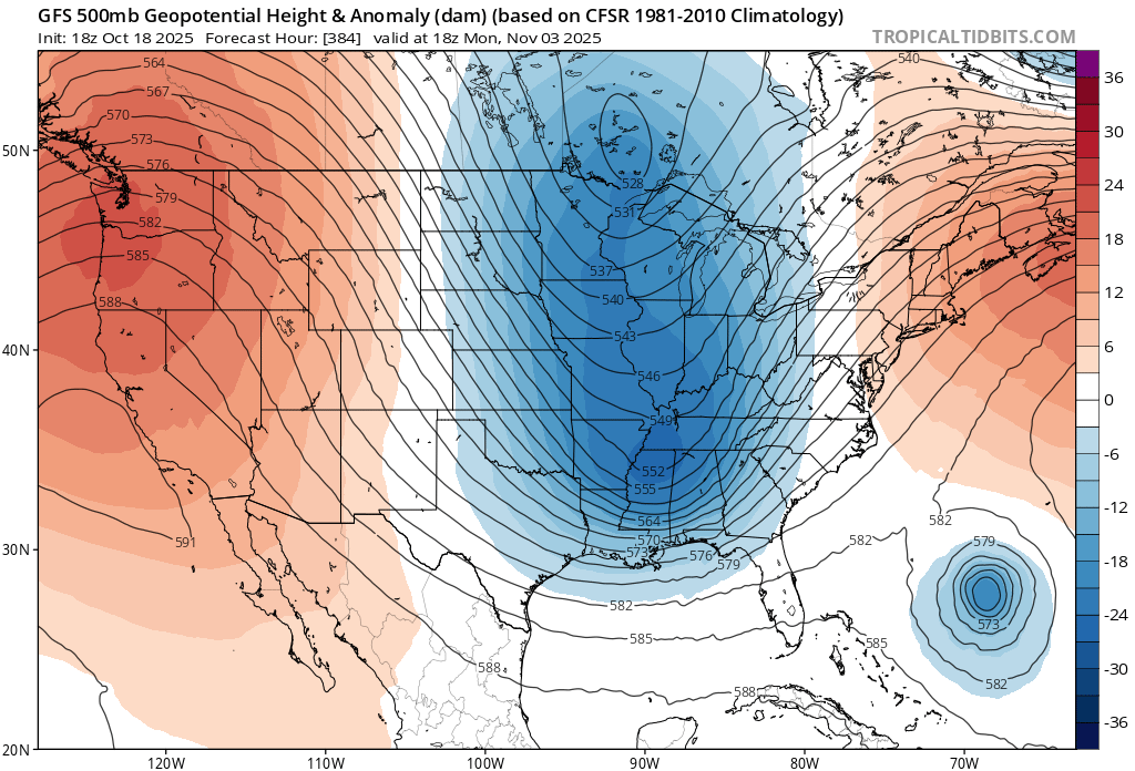
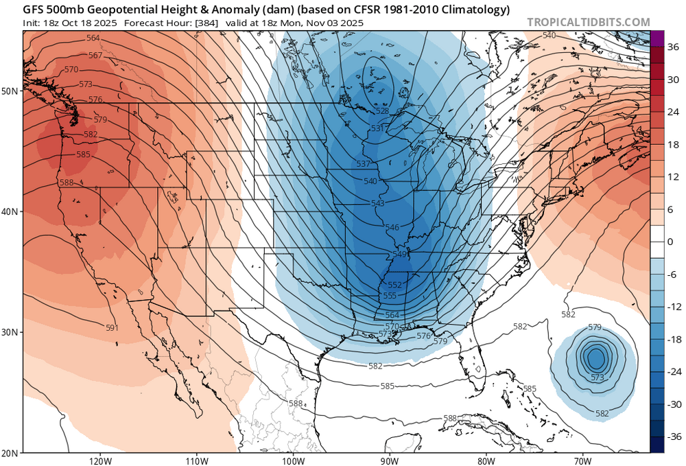
It’s a new pattern which just developed in the last decade. Record ridging and sunshine over the WPAC leading to these record SSTs. So once Siberia begins getting cold in the fall a strong temperature gradient develops driving the Pacific Jet.
-

Spooky Season (October Disco Thread)
HoarfrostHubb replied to Prismshine Productions's topic in New England
Stein will save us -

2025-2026 ENSO
Stormchaserchuck1 replied to 40/70 Benchmark's topic in Weather Forecasting and Discussion
I was surprised NOAA had 19 Named Storms at the high end of their range this season.. their high end was 25 Named Storms last season.. they have been too high 2 years in a row. Global ACE hasn't been as the same as Atlantic ACE and I think that is going to level out a bit in the coming years. As for the MJO, long range models have been trying with the idea of a +PNA last few days of October, into the first week of November. It will be interesting to see how that verifies.. I think there is some expectation of the MJO making it to Phase 7. -
Yeah I think so. March was the snowiest month of the season.
-
The new model runs are showing a brick wall of subsidence continuing in the tropical PAC. It’s been in place for months now (Niña/-IOD related). Don’t be surprised if the MJO wave doesn’t make it very far east of the Maritime Continent (phase 7) before it completely dies off. As far as the Atlantic hurricane season, I think after whatever forms in the central Caribbean next week, the season comes to an end. I don’t think it will be any threat at all to the U.S. mainland and it probably just moves west and buries itself into South America or gets picked up and swept way OTS in the westerlies
-
Stacking^
-

Spooky Season (October Disco Thread)
kdxken replied to Prismshine Productions's topic in New England
- Today
-
I’m very confident that we see an Aleutian ridge regime this winter as opposed to an Alaskan ridge regime. I’m also extremely confident that we see a lot more -PNA this winter as well, if I’m wrong, I’ll own it
-
Gfs and nam runs this morning drop less than a quarter of an inch on most of the area. Yippee.
-
2025-2026 ENSO
Stormchaserchuck1 replied to 40/70 Benchmark's topic in Weather Forecasting and Discussion
We're not going to so easily hold a Winter -PNA if this subsurface cold pool doesn't re-strengthen I've found that the subsurface around the thermocline is most important of all ENSO variables for correlating North Pacific pattern. -

Spooky Season (October Disco Thread)
ineedsnow replied to Prismshine Productions's topic in New England
Euro was amazing! -

Spooky Season (October Disco Thread)
SnoSki14 replied to Prismshine Productions's topic in New England
Potential for a big storm is there late month. Lots of blocking plus hurricane activity -

Spooky Season (October Disco Thread)
WxWatcher007 replied to Prismshine Productions's topic in New England
-
E MDR AEW: models support Car. TCG next wk
WxWatcher007 replied to GaWx's topic in Tropical Headquarters
This one is really interesting. It looks to have a more favorable environment in the Caribbean, and there seems to be two camps on the ensembles with one camp turning it northeast pretty soon and the second getting this further west. Too soon to say which one is right. This is a threat in the Caribbean, less clear it can impact the continental US, though I’d watch the troughing in the east at the end of October. Tropical Weather Outlook NWS National Hurricane Center Miami FL 200 AM EDT Sun Oct 19 2025 For the North Atlantic...Caribbean Sea and the Gulf of America: East of the Windward Islands and the Caribbean Sea (AL98): A tropical wave located a couple of hundred miles east of the Windward Islands is producing a large and persistent area of showers and thunderstorms. Recent satellite-derived wind data indicate that the system still lacks a closed circulation, but is producing winds of 30 to 35 mph north and east of the wave axis. Environmental conditions are expected to limit development during the next couple of days as the system moves quickly westward at 20 to 25 mph, bringing heavy rainfall and gusty winds to the Windward Islands beginning later today and continuing through Monday morning. By the middle to latter part of the week, environmental conditions are forecast to become more conducive for development, and a tropical depression could form while the system slows down over the central Caribbean Sea. * Formation chance through 48 hours...low...10 percent. * Formation chance through 7 days...medium...50 percent. $$ Forecaster Jelsema -
Spooky Season (October Disco Thread)
WxWatcher007 replied to Prismshine Productions's topic in New England
Well the Euro would be an all timer. Drought bustah. -
I don’t track winter particularly closely until I need to but I’m actually cautiously optimistic. Just not sure it’s another cool one—though things look pretty similar to last year at this time.
-
So seems like we are canceling winter before it starts? Glad I don't have to wait on heartbreak later on but can just get it out of the way.
-
.thumb.png.4150b06c63a21f61052e47a612bf1818.png)
Spooky Season (October Disco Thread)
HIPPYVALLEY replied to Prismshine Productions's topic in New England
Same with the Connecticut river coming through Turner Falls and Deerfield. -
The SOI never went strong during the 23-24 Strong Nino. Here's the monthly data: 2023 4 -1.20 2023 5 -15.26 2023 6 -3.19 2023 7 -3.32 2023 8 -10.85 2023 9 -13.87 2023 10 -6.63 2023 11 -8.38 2023 12 -3.78 2024 1 3.96 2024 2 -15.55 2024 3 -0.35 From 2020-early 2023 we had 34-straight months of +SOI.... so this decade there has been a severe +SOI tendency compared to other ENSO variables. Oct 2025 is likely going to make the 15th straight month of +SOI, although none of those months have gone over +10.. it's been consistently weak Nina/negative-Neutral for 2 years now... and La Nina-like SOI for 5+ years, with a little blip to slightly negative during the 23-24 Nino.
-
Yea that lake water isn’t coming back. Maybe for the best. Let nature be nature
-
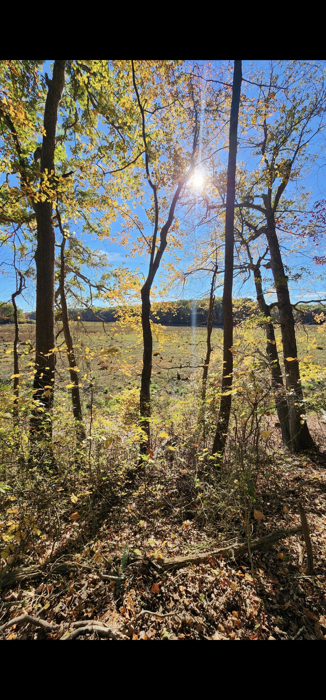
Blydenburgh County Park in Smithtown Friday afternoon

-
Blydenburgh was beautiful Friday afternoon. It's wild watching how fast the brush has taken over the lake bed.
-

Spooky Season (October Disco Thread)
Torch Tiger replied to Prismshine Productions's topic in New England
-
It would not surprise me if it dies when it enters phase 7