All Activity
- Past hour
-

July 2025 Obs/Disco ... possible historic month for heat
weatherwiz replied to Typhoon Tip's topic in New England
I don't disagree with that. When you have these mornings after a super hot/humid day and you bring in this airmass overnight it feels great in the morning. It's hard to explain but because it got cool quickly last evening, I hated it more this morning lol. Like say it was really humid during the evening and then cooled overnight...I would have enjoyed better. -
79/74 with a dew of 70. Was out pulling weeds, only thing that is keeping green with our rain shut out here. Could feel the humidity but because it is partly cloudy the feels like temp is 82. Catio is still out with 2 out of 3 furballs enjoying it. Figured let them out as probably tomorrow it will be coming back inside.
-
0.69" of rain yesterday. Another round moving in soon. 6.34" for the month so far. Could land in the top 10 wettest July's this year. #15 right now.
-

July 2025 Obs/Disco ... possible historic month for heat
Great Snow 1717 replied to Typhoon Tip's topic in New England
.....eh...feels great at this time of the year -
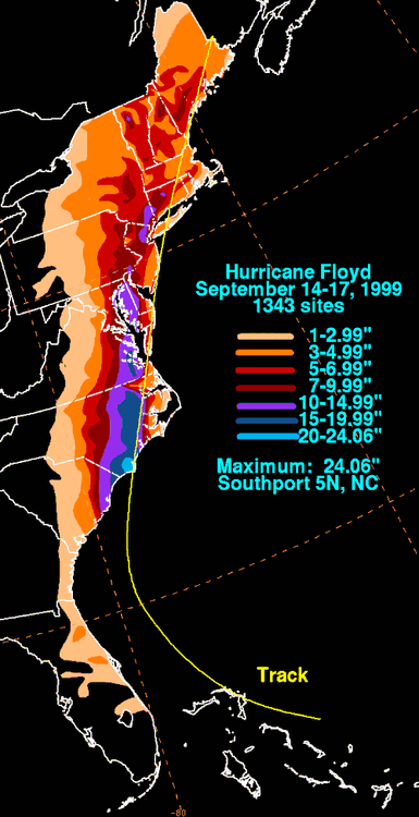
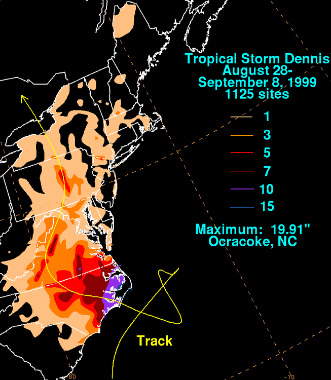
Denise, and Floyd rainfall totals it does look like more than half came from non tropical systems :
-
July 2025 Obs/Disco ... possible historic month for heat
weatherwiz replied to Typhoon Tip's topic in New England
It was lower 50's...that's certainly cool. If people's houses were 50's they'd be turning on the heat. -

July 2025 Obs/Disco ... possible historic month for heat
MegaMike replied to Typhoon Tip's topic in New England
Right? Super cool! I believe they used VAPOR to create most/all of their graphics. Agreed in that I doubt they'll be able to replicate their success for most other tornadoes -
July 2025 Obs/Disco ... possible historic month for heat
Great Snow 1717 replied to Typhoon Tip's topic in New England
what chill???????? -
89’d yesterday. Nice grouping of thundershowers popping up all over eastern Minnesota this morning.
-
If we're going to get a big severe event this summer, next week is the window. Looks solid at this range.
- 1,307 replies
-
- 1
-

-
- severe
- thunderstorms
- (and 2 more)
-
July 2025 Obs/Disco ... possible historic month for heat
weatherwiz replied to Typhoon Tip's topic in New England
Not full blown...just enough to eliminate the chill. Outside of our bedroom and living room where the ACs are cranking down to like 66 the rest of the house is like 75-80...so going from that to 50's is a bit of a shock lol. 50's and sun...fine...50's with no sun set...not fine -
July 2025 Obs/Disco ... possible historic month for heat
Great Snow 1717 replied to Typhoon Tip's topic in New England
c'mon lol -

July 2025 Discussion-OBS - seasonable summer variability
LibertyBell replied to wdrag's topic in New York City Metro
2011: Chicago set an all-time daily record rainfall when 6.86 inches fell during the early morning hours of Saturday, July 23, 2011, at O'Hare airport. The previous daily record was 6.64 inches set on September 13, 2008. wild while Chicago was flooding, we were in the midst of a 2 day extreme bake off. Today was the second day of the bakeoff: Records: Highs: EWR: 102 (2011) NYC: 100 (2011) LGA: 100 (1955) JFK: 102 (2011) New Brnswck: 105 (2011) LGA: 59 (1992) JFK: 59 (1992) I also remember Pinatubo cooled 1992....the year without a summer (we had a quick rubber band effect between 1991-1992-1993). -

2025 Atlantic Hurricane Season
Normandy Ho replied to BarryStantonGBP's topic in Tropical Headquarters
Fuck man RIP for real. Burns was a real one -

2025-2026 ENSO
40/70 Benchmark replied to 40/70 Benchmark's topic in Weather Forecasting and Discussion
Heh....closest I have been to normal since 2017-2018 is about 10" shy in 2020-2021. I haven't been sniffing normal. Its always either north of south of me. -
Both 2-4°C of warming and cooling at the current pace of anthropogenic warming would be catastrophic. Non-transient changes like that do not happen at that sort of rate. Leaving out a time factor in the polls is in poor practice, because it creates a hypothetical environment of set warming or cooling with no time horizon. I think it's better to ask, if we were instead on pace for 2-4°C of cooling by the end of the century, and we knew we were the cause, would we try to pause that trend by mitigating our actions?
-
July 2025 Discussion-OBS - seasonable summer variability
LibertyBell replied to wdrag's topic in New York City Metro
Looks like we won't see dry and coolish weather like we have had the last few days until the first week of August? -
July 2025 Discussion-OBS - seasonable summer variability
LibertyBell replied to wdrag's topic in New York City Metro
1999 had one of our hottest summers and 2 of our longest heatwaves ever. I'm surprised July 2010 isn't up there at your station though. -
GFS pretty insistent on patches of 80s dews late this coming weekend/early next week.
-
July 2025 Obs/Disco ... possible historic month for heat
weatherwiz replied to Typhoon Tip's topic in New England
Wow...that is incredible!!! The part where you have the warm/moist air along the FFD feeding into wall cloud and funnel was probably my favorite part. That was probably the best visual/simulation I've ever seen. Granted this was one of the most textbook tornadoes captured on record but still. This deserves to be included in any severe wx class (undergrad or graduate). -

July 2025 Discussion-OBS - seasonable summer variability
IrishRob17 replied to wdrag's topic in New York City Metro
Meh, that rounds to 60 and you know it LOL. 53 and 58 up here in the great north woods the past two mornings -
Actually a pleasant start to the day. A bit of breeze, good cloud cover, actually feels a bit stormy. Would love to see temps bust today
-

July 2025 Discussion-OBS - seasonable summer variability
psv88 replied to wdrag's topic in New York City Metro
59.9. We did it -

July 2025 Obs/Disco ... possible historic month for heat
dendrite replied to Typhoon Tip's topic in New England
GFS is trying to deliver a frost/freeze to the pits of NNE.
-
July 2025 Obs/Disco ... possible historic month for heat
MegaMike replied to Typhoon Tip's topic in New England
My advisor would always tell me that! Someone did manage to simulate a tornado (EF5 in El Reno 2011) using a modeling system intended for very fine atmospheric phenomena (CM1): https://www.mdpi.com/2073-4433/10/10/578 If you wanted, had the resources (19,600 nodes -> 672,200 cores & 270 TB worth of space), and had a lot of time, you can run the simulation too! In serial mode (single CPU), it'd take decades for this simulation to complete. Really, we have the modeling systems to run highly accurate simulations, but unfortunately, data assimilation and (relatively) limited resources is inhibiting us. A nice video of the results:


