All Activity
- Past hour
-
Thank you for posting Walt. Hope you’re feeling well, please don’t give up on us.
-
I'm telling you especially if you live north
-
Well IMO he's partially right, the -NAO obviously helps but it's mainly because a 1050 high squashes everything
-

January 2026 regional war/obs/disco thread
SnoSki14 replied to Baroclinic Zone's topic in New England
Here's another real test to see how legit these AI models are. -

January 2026 regional war/obs/disco thread
ineedsnow replied to Baroclinic Zone's topic in New England
are you enjoying the snow that you said wasn't coming? -
 Weatheriscool changed their profile photo
 -

Richmond Metro/Hampton Roads Area Discussion
eaglesin2011 replied to RIC Airport's topic in Mid Atlantic
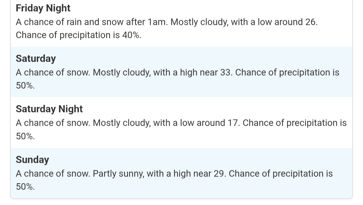
Well one thing is for sure.. Its going to be cold this weekend for sure.. Let’s just hope it doesn’t get too cold that it suppresses the whole storm more south…(that seems the way things have trended the past few years) Depending how early it starts on Saturday…I can see some ice mixing in for awhile.. Hopefully this area can avoid the dry area curse and get a nice 4-8 inch storm with some ice mixing in at times … With the cold air forecast.. It will definitely stick around a few days… Still too early to predict how it will go.. We know how it normally turns out when we are in the bullseye this early… -
January 2026 Short/Medium Range Thread
Weatheriscool replied to John1122's topic in Tennessee Valley
And I will add, we will probably make a run at zero or below those that have a snowpack for Monday morning next week -

Rise of the Machines: January 18-19 Winter Storm Obs Thread
HoarfrostHubb replied to WxWatcher007's topic in New England
Rippin fatties here too -
January 2026 regional war/obs/disco thread
ineedsnow replied to Baroclinic Zone's topic in New England
they did so good with the last storm -

January 2026 regional war/obs/disco thread
Sey-Mour Snow replied to Baroclinic Zone's topic in New England
At this stage every model was, euro and gfs were completely out to see 48-60 hours out for Sunday's storm -
Oh my bad I was looking at the gifs in the wrong order, lol Darn it
-
January 2026 regional war/obs/disco thread
Sey-Mour Snow replied to Baroclinic Zone's topic in New England
https://www.jdjweatherconsulting.com/feb-16-17-2003 Resemblance is wild.. need to trend this 250 miles north in 5.5 days.. @ORH_wxman whats your recollection on PD2 and the last 48 hours trend north? -
January 2026 Short/Medium Range Thread
Weatheriscool replied to John1122's topic in Tennessee Valley
Still depicts a disruptive, plowable snow for most all of the state. -
January 2026 regional war/obs/disco thread
SnoSki14 replied to Baroclinic Zone's topic in New England
Way too early to make this declaration. At this stage the Euro was completely OTS on yesterday's system -
Thanks, here to observe and learn, the days of doorman, PSU and others from the different forms was always a great reading.
-

Rise of the Machines: January 18-19 Winter Storm Obs Thread
CoastalWx replied to WxWatcher007's topic in New England
Yeah I’ve been teetering. But when you constantly get porked it goes right to your head. This feels great. Still not sure if I’ll break 6” lol. But I’ll take it. -

Rise of the Machines: January 18-19 Winter Storm Obs Thread
Bryan63 replied to WxWatcher007's topic in New England
Some nice steady snow again just fluffing things up -

January 2026 Short/Medium Range Thread
Holston_River_Rambler replied to John1122's topic in Tennessee Valley
Here are the 6z EPS members for your viewing pleasure: -
RAH is quite bullish

-

Pittsburgh/Western PA WINTER ‘25/‘26
TheClimateChanger replied to Burghblizz's topic in Upstate New York/Pennsylvania
Eyeballing, but it looks like close to an inch of snow last night. Didn’t realize it was supposed to snow. -
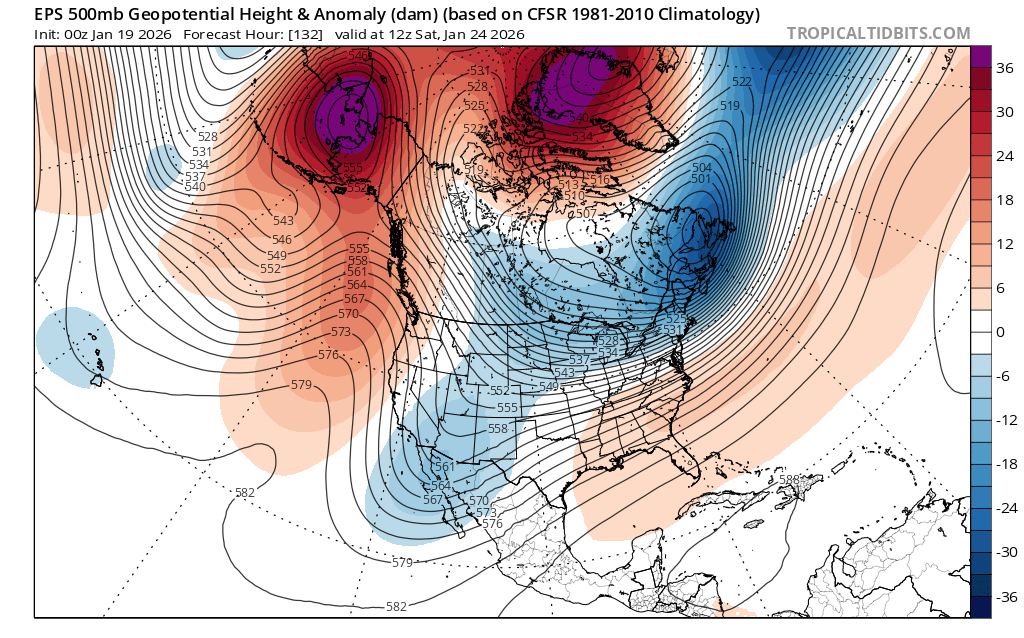
Disclaimer: I'm not the expert at upper level analysis by any means But this doesn't look quite like the "HECS" look that supports a low that strong though its a very good pattern This is -EPO, -NAO, with a neutral looking PNA with the ridge offshore. The -EPO delivers arctic air while the -NAO stops the storm from cutting NW. But for a truly historic storm it would seem like we'd need the ridge a few hundred miles east which would push the trough southeast over the TN valley and phase with the subtropical energy and create a stronger storm. This looks like it would support, at the upper potential, an overrunning event like Jan 2010 or... Dec 2018 (you all would love that if it had been 100 miles north) with widespread double digits totals, but not the 18-24"+ totals that would be "historic".

-
6z ICOn was setting up nicely too.
-
I know, that's why I posted. It shifted south.
-
Rise of the Machines: January 18-19 Winter Storm Obs Thread
CoastalWx replied to WxWatcher007's topic in New England
Man I’m just staring outside. Boy did I need this. This is pristine winter. -
January 2026 regional war/obs/disco thread
Sey-Mour Snow replied to Baroclinic Zone's topic in New England
Yes and regardless what model, Richmond is ground zero right now, some of the means are unreal.. Still 5.5 days out plenty of time to pull her north..