All Activity
- Past hour
-

Appreciating Each Other/Poster Compliments
WxWatcher007 replied to SnowenOutThere's topic in Mid Atlantic
Man, this thread is so wonderful to read. I’m not around as much in this region as life has taken me further north, but this subforum will always be home to me. -
30 at 8:05p. Now it's 38 in front of the precipitation at 1a. Don't think that's gonna get it done.
-
Has the models so far tonight changed to not showing any winter storms?
-

Mid-Long Range Discussion 2026
WinstonSalemArlington replied to BooneWX's topic in Southeastern States
We have a new avatar -
Digital Snow/Ice Thread 2025-2026
WinstonSalemArlington replied to WinstonSalemArlington's topic in Southeastern States
New Avatar -
The models that showed this just drying up imby are spot on. Their thermals were off, but the dryness was perfect. It's barely sprinkled here so far. Temp has fallen to 38.
-

Jan 17-18 Sunday Funday Storm
gamecockinupstateSC replied to NorthHillsWx's topic in Southeastern States
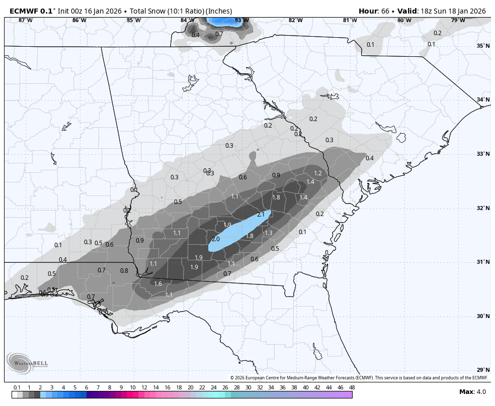
Euro increased measurable snow from Newberry to Greenville SC. .5 to .8 amounts. Nothing major but better last three runs. 1 inch line approaching Augusta GA/SC line. Hopefully a few ticks like this more can occur.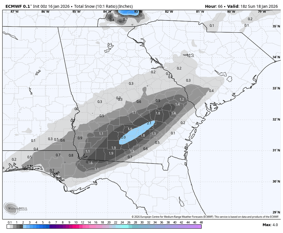
-
HRRR at 24 hours is like the NAM at 84. Latest runs look more realistic. Unfortunately
-

First Legit Storm Potential of the Season Upon Us
wxsniss replied to 40/70 Benchmark's topic in New England
0z EC AIFS actually small tick NW compared to 18z, but did not regain the big hit that was 12z... still advisory most of SNE, warning southeast of Plymouth 0z EC also small tick NW... but mostly nuisance low-end advisory outside of Cape -
Really emphasizes that when things get warm they shatter records and the opposite side is only average to modestly BN at best.
-
Started snowing here at 12. Dusting on Vehicle and patches on lawn. Temperature is 37 . Dp 19.
-
???
-

January 2026 Short/Medium Range Thread
WintryMixmaster replied to John1122's topic in Tennessee Valley
I remember growing up in New Jersey that the "cold/dry alternating with just warm enough to rain/wet" pattern was the absolute worst, but I'm surprised how often its happened here this winter (and a bit of last winter too). 40-50 degree rain isn't unexpected but the fact that we've had a lot of cold weather - just not synced up with storms - is really frustrating -
We need to get something under 84 or we are going to kill each other lol
-
That was pretty good. How did you come up with that gem? And who are you?
-
Hrrr down to 1-1.5” getting lower each run. Ready to wake up to nothing lol
-
500mb setup should allow the coastal to track further west and dump a foot or two from Goergia to Maine. Of course its fantasy land and nothing like that will verify.
-
Well all the storm possibilities aside.. it does look like an extended period of cold below normal temps!! For at least the next 2 to 3 weeks and into February. So if we can keep that STJ going somethings bound to connect the right way for a good snowstorm!
-

-
Also, that is one hell of a fantasy storm for the SE on the GFS at the end of the month. Crushes everyone except TN so it's plausible.
-
Amen brother!!!!
-
It’s like some forget how this works on OP runs at long range…all I took away is there continues to be an above avg change of a snowstorm in the east during that period like you said. It will show hits in the SE, MA, NE or all of them - on various OP runs until we get into range.
-
Just have to make sure we don’t track for 2 months all for a 3-5
-
Digital Snow/Ice Thread 2025-2026
WinstonSalemArlington replied to WinstonSalemArlington's topic in Southeastern States
January 30 Crusher -
Knoxville is warmer than most of Florida this evening. Looking at a temp map is gross right now.