All Activity
- Past hour
-

2025-2026 ENSO
KakashiHatake2000 replied to 40/70 Benchmark's topic in Weather Forecasting and Discussion
hmm i just think maybe it is something interesting to think about but what if we incorporate ai and machine learning with strictly in regards to sst and climate change itself not trying to say that we should replace everything with it but just have it as one of our tools in our arsenal -
WB 12Z EPS for late in the weekend, wetter than 0Z. Note: great write up in the tropical thread on this by 007.

-
 The magnitude of the heat and drought in Canada is much more extensive this time around as the climate continues to warm. Those past events you referenced were normal occurrences back in the colder and more stable climate of the past. What has been occurring in Canada since 2023 is a whole new ballgame. First, we had the historic 500mb ridge over Canada in May 2023 leading to the historic wildfire outbreak and record smoke pollution in places like NYC. This standing wave which drove the drought and fires was related to record warming in parts of the Pacific which helped to lock in the record heat and 500mb ridging in Canada from 2023 to the present. Second, the current global political system is not capable of dealing with all the cascading effects of this rapid warming. So the response will have to be more driven by informed individuals that can make their own personal decisions on how to respond to this new climate.
 -
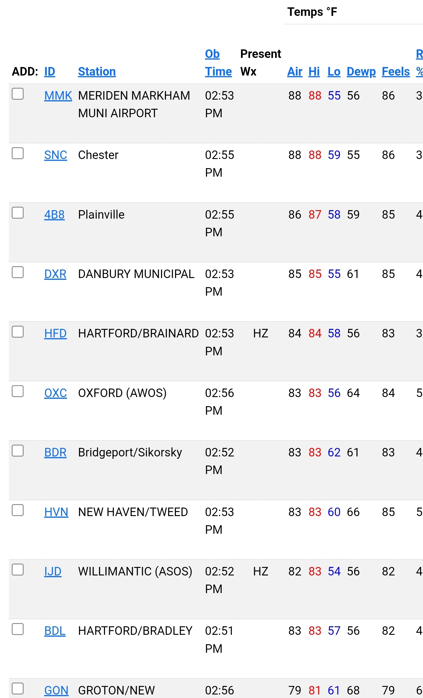
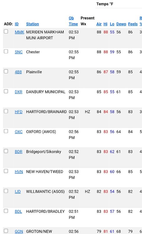
 90 with a dewpoint of 56 here. 90 feels pretty good with the low humidity.
 -
Some smoky and sneaky heat out there today..
-
The 12Z UKMET has Dexter eventually becoming a minimal 988 mb H on Thursday though that’s an outlier right now:TROPICAL STORM DEXTER ANALYSED POSITION : 35.0N 67.5WATCF IDENTIFIER : AL042025LEAD CENTRAL MAXIMUM WINDVERIFYING TIME TIME POSITION PRESSURE (MB) SPEED (KNOTS)-------------- ---- -------- ------------- -------------1200UTC 04.08.2025 0 35.0N 67.5W 1005 360000UTC 05.08.2025 12 36.3N 65.9W 1008 351200UTC 05.08.2025 24 37.8N 63.9W 1010 340000UTC 06.08.2025 36 39.2N 62.3W 1008 431200UTC 06.08.2025 48 39.5N 59.8W 1007 410000UTC 07.08.2025 60 40.3N 56.0W 1003 391200UTC 07.08.2025 72 41.2N 51.3W 993 540000UTC 08.08.2025 84 43.2N 46.2W 988 651200UTC 08.08.2025 96 45.0N 42.6W 985 480000UTC 09.08.2025 108 46.0N 36.8W 993 401200UTC 09.08.2025 120 47.2N 29.8W 999 360000UTC 10.08.2025 132 CEASED TRACKING
-
I understand. I’m just talking fires in general.
-
 Sneaky warm day-just hit 90.
 -
You are looking at the global temperature jump in linear terms. First, what seems like a small rise in average global temperatures has much more amplified effects regionally. Second, SSTs in some tropical and even subtropical zones areas can cross a threshold where a nonlinear shift occurs. Resulting in standing waves that remain stationary for extended periods leading to very high local to regional warm departures. Unfortunately, there isn’t a guide we can consult which has a set SST level at which the changes will occur. As the climate is warming faster than our modeling technology can keep up with. So many of these shifts are only realized after the fact.
-
 88 with 61 dew point What fantastic summer weather
 -
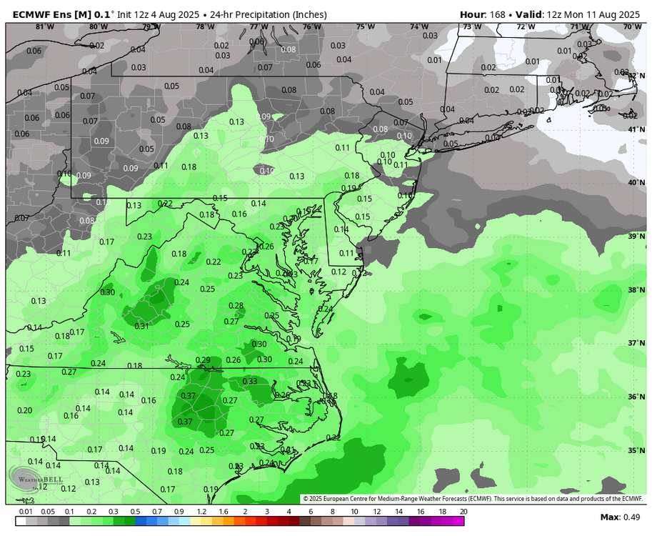
The models have dried for Wednesday and Thursday and Sterling has went wetter for Staunton. https://forecast.weather.gov/MapClick.php?lon=-79.05445863492788&lat=38.16380555335593
-
Please do Will. I always look forward to your Updates!!
-
yeah let it rip...
-

E PA/NJ/DE Summer 2025 Obs/Discussion
RedSky replied to Hurricane Agnes's topic in Philadelphia Region
Milky sky and hazy visibility with the smoke No smoke odor -
zzzzzzzzzzzz hopefully we get some canes going soon to give us something to track
-
 Fishing yes, boating, not so much...
 - Today
-
cat 5 into miami or bust
-
I think that dude is either in denial and just says "la la la can't hear you", or is just doing that to troll...been the habit pretty much since this tough stretch began. All we have to go is what's happened the last 9 (and likely 10) years. The reality is just what you stated. Now whether or not we get out of the PDO cycle and we can put together a better 10-year stretch remains to be seen...but at least for now this is where we at.
-
 it reached 88 here, a good day aside from the off color sky lol
 -
But why is it happening every year now Roger? Are there chemicals they could spray over the forest from a plane to cause fire suppression?
-
was the streak of 42 consecutive days of 100+ also broken Don?
-

SE Area of Interest--0% two day, 30% five day odds
WxWatcher007 replied to WxWatcher007's topic in Tropical Headquarters
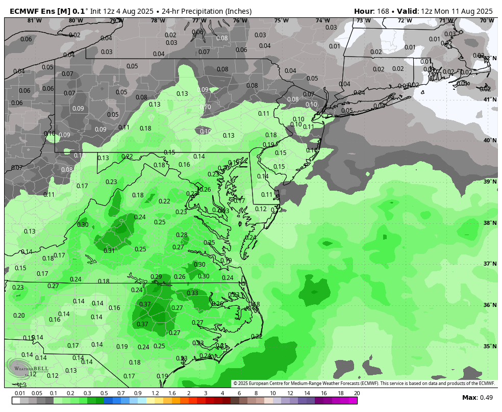
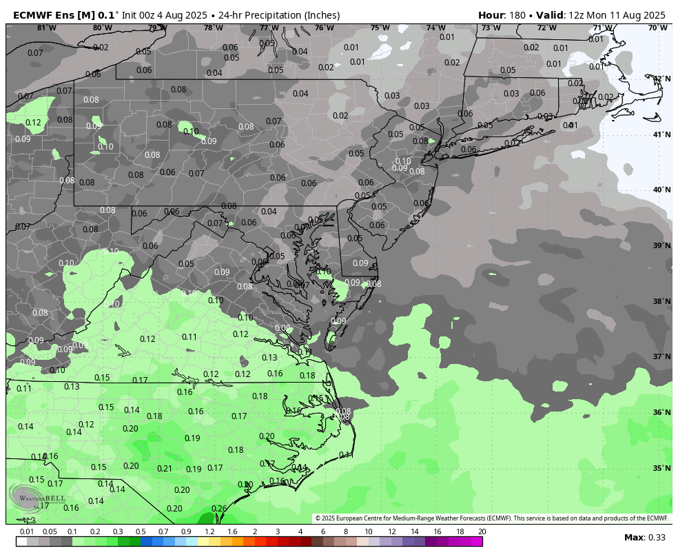
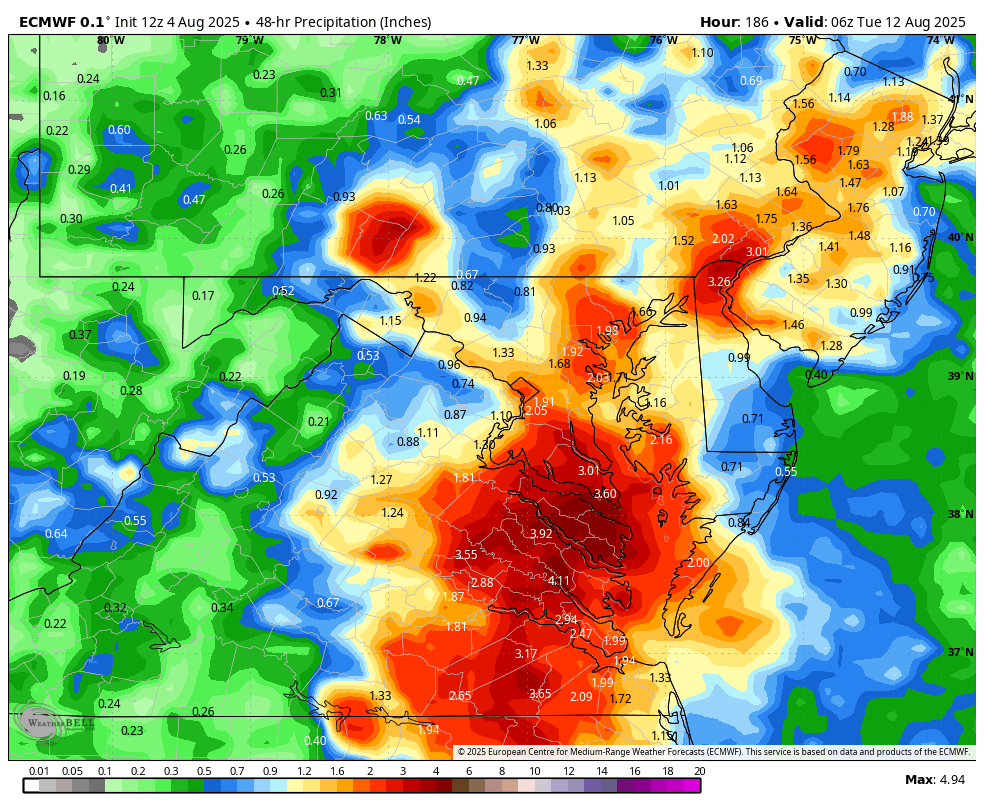
12z Euro was a bit more robust at 850mb. Gets a good bit of rain into NC and points north. I think that much like Dexter, models could be playing catch up with this if there is a pocket of lighter shear available to the eventual low. -
a bunch of the fires are nowhere near people
-
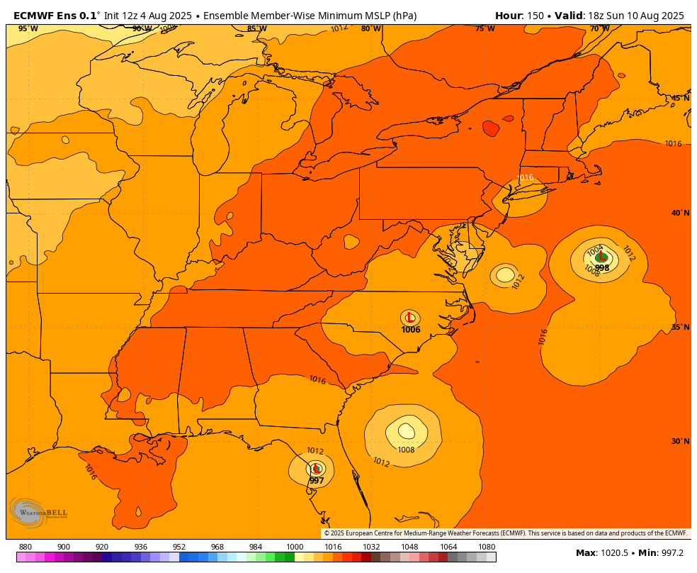
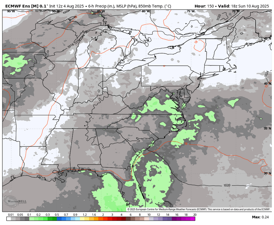
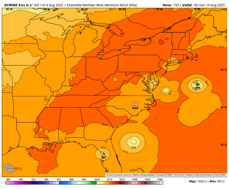
Yes, big win for GFS this week, but the EURO is trying to bring up a disturbance late Sunday into Monday now. Will add ensemble when it is out.