All Activity
- Past hour
-
Shades of '11 Definitely will be that kind of a week with the cutoff low impacting the area a good part of this week as the Omega Block forms by the end of the week according to DT. Fall begins Tuesday night, and it will certainly feel like it!
-

Septorcher 2026 Discussion - Endless Summer
vortex95 replied to Damage In Tolland's topic in New England
@CoastalWx must relent! And yes, it might just be a "COASTAL WX" sig impact event, but so was the Perfect Storm in 1991! -
Septorcher 2026 Discussion - Endless Summer
vortex95 replied to Damage In Tolland's topic in New England
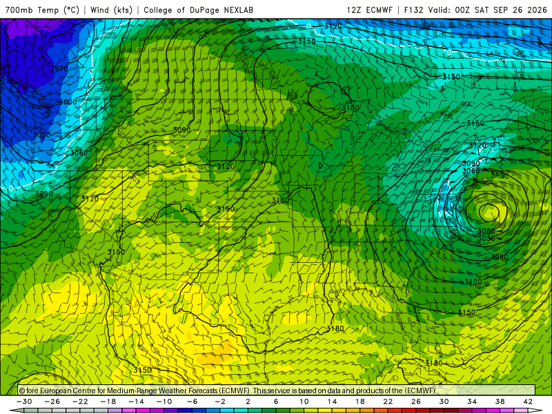
12z ECMWF by 132 hr showing a strong warm seclusion unfolding (-6 C at 500 and +11 C at 700). I will get way ahead of myself and say this now, and an excuse to talk about past policy and events! The problem I see here is not whether it goes ST, it is the messaging. A strong non-tropical low then going ST and getting a name when it is sitting close to the coast? That is big problem for messaging b/c non-tropical wind warnings would have to be changed to tropical wind warnings! I do not know of any case like this this close to the coast, but similar things have happened. The Perfect Storm in Oct 1991. Once it deeply occluded, it drifted S of the Gulf Stream and become a hurricane, but they did not call it such operationally *even* thought they had a recon in it and found a 981 mb pressure and 88 kt FL winds! I found that disingenuous, as it was abundantly clear what it was, but NHC did not name it, and only included it in post-season analysis. The reasoning was they did not want to confuse the public, as the public may have thought the storm was a hurricane all along and cry foul. Such would never happen today b/c of the internet and social media. Back in those days if NHC could get away w/ not declaring a high latitude or out of season TC and defer it to post-season analyses, they would. But it has gone further. In Sep 1992, there was a small hurricane that quickly developed just N of TXKF, and it passed close to Sable Island when it was starting to weaken on sat, but they still recorded 55-60 kt winds. It was not even included in post-season analysis! In the TWO, it said, "moving towards cooler waters." That was "out phrase" for NHC not to declare something back then. Again, disingenuous and I find lazy. Just b/c something only exists for a short time, does not mean it does not exist! There are 5 suspect TCs in 1992 alone that will likely get included in HURDAT once the reanalysis project gets into to the 1990s (they plan to go to 2000). And for those wondering, the pre-Christmas 1994 storm ( the @CoastalWx “how did you know about that?” event) is a likely candidate for a 70 kt hurricane, peaking at 70 kt / 969 mb near 40/70.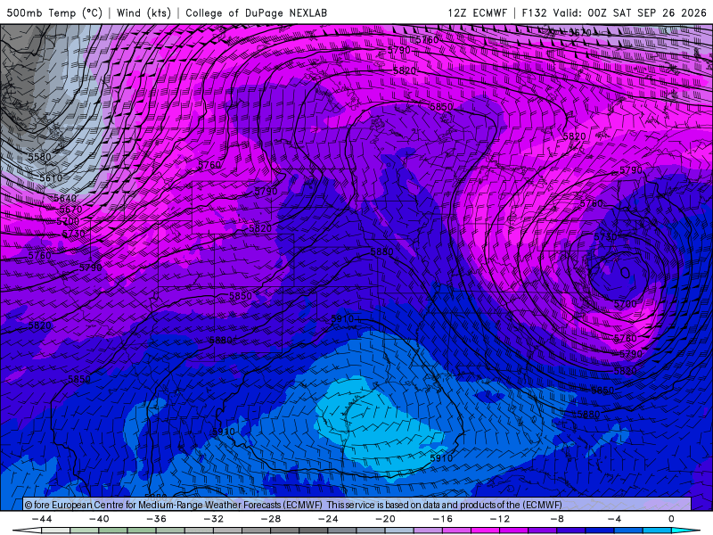
-

2026-2027 Record-breaking El Nino
MJO812 replied to Stormchaserchuck1's topic in Weather Forecasting and Discussion
LoL declaring winter over in September. You never learn . You do the same thing every year. -

2026-2027 Record-breaking El Nino
SnoSki14 replied to Stormchaserchuck1's topic in Weather Forecasting and Discussion
You're gonna love 60s and 70s in December and probably every cold month this winter. It's not gonna be a good time for snow lovers so pray for a miracle. -
2026-2027 Record-breaking El Nino
MJO812 replied to Stormchaserchuck1's topic in Weather Forecasting and Discussion
We have the Halloween decorations up already in our apartment. Love the Ber months. -
We'll take care of that this year.
-
 Between the -PDO, +PMM, and El Nino it certainly is a torch out there! Most people will see that and just say "global warming". We know that a lot of that stuff is cyclical although I'm wondering if +PDO ever comes back in my lifetime (maybe for 2-3 years at some point like '13-16).
 -
Septorcher 2026 Discussion - Endless Summer
vortex95 replied to Damage In Tolland's topic in New England
If this was Jan, you'd be all in at this point! -
DCA has an 80 degree day recorded for every month except for December.
-
Septorcher 2026 Discussion - Endless Summer
vortex95 replied to Damage In Tolland's topic in New England
No back-pedaling allowed! Your initial approach was, "ho-hunm, maybe we can get something" said in EEYORE tone, despite strong signals in the models. -
Septorcher 2026 Discussion - Endless Summer
vortex95 replied to Damage In Tolland's topic in New England
How about those 12z ECMWF rainfall totals when all is said and done? 9.95" right over Weymouth! Would be among the best Nor'easters in Sep for the region.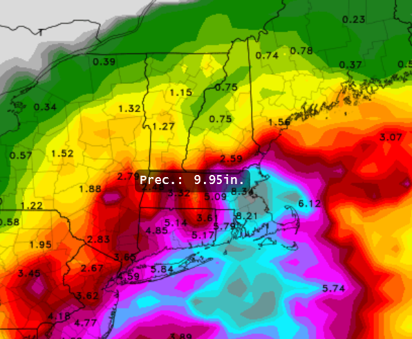
-

Septorcher 2026 Discussion - Endless Summer
CT Valley Snowman replied to Damage In Tolland's topic in New England
Picked up about .5 here and it was a pretty lousy day with sheet drizzle after the steadier rain moved through. Good afternoon for football and indoor activities. -

2026-2027 Record-breaking El Nino
raindancewx replied to Stormchaserchuck1's topic in Weather Forecasting and Discussion
Wettest month in two years here, so far. Another ~2 inches of rain, by month end, as currently forecast would make this the wettest month since at least July 2015 or Sept 2013, depending on exact amounts. Any month with even three inches of rain is vanishingly rare here. We had two inches of rain in the city this week, and it abruptly killed the heat (90s/100s) we've had almost every day since May. El Ninos with >average rain in Jun-Sept locally tend to behave better as "cold" and or/severely "snowy" winters locally. Looks like we may pull that out yet, even with Jun-Aug well below average. 17E in the E Pacifc may help a bit in the short/medium term as well, by keeping MX flush with moisture. -
(002).thumb.png.6e3d9d46bca5fe41aab7a74871dd8af8.png)
E PA/NJ/DE Autumn 2026 Obs/Discussion
ChescoWx replied to PhiEaglesfan712's topic in Philadelphia Region
Some nice rain totals across Northern Chesco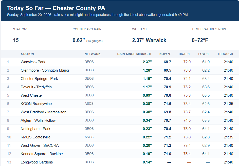
-

2026 Atlantic Hurricane Season
Boston Bulldog replied to Stormchaserchuck1's topic in Tropical Headquarters
Might be a touch of northerly shear impacting Fay now as well. Distinct southerly shunting of the convection can be seen on IR - Today
-
2026 Atlantic Hurricane Season
vortex95 replied to Stormchaserchuck1's topic in Tropical Headquarters
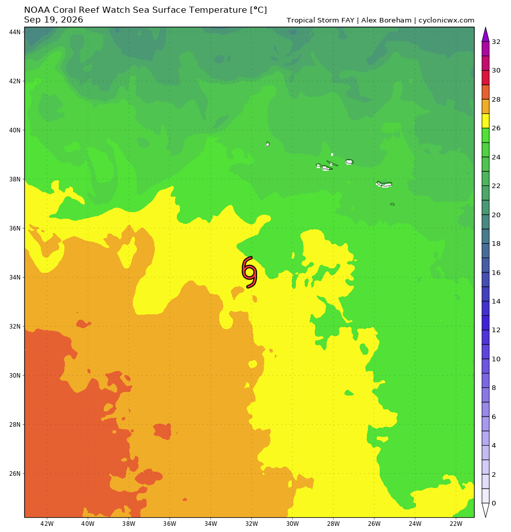
Yes, a dry air slot. Look at the last few EIR frames. It is possible since it has not moved much at all, some upwelling is taking place now as well. 00z ATCF gives it 60 kt/995 mb. Hard to get a T4.0 (65 kt) from Dvorak w/o an eye or embedded center pattern. You need excellent banding and very cold cloud tops for a 4.0 when a banding pattern is applied. Tiny TCs are indeed not handled well by Dvorak, however, that largely applies when there is an eye (can't get a cold ring thickness wide enough for proper T-numbers). Also, Fay is over marginal SSTs (see attachment) and not in pure tropical environment, so the mixing down of the higher winds aloft 500-800 m up is not ideal. I'm just pointing these factors out now b/c I'm sure you'll see discussions/debate if it was a hurricane or not, pending the next 6-12 hr! Still, Fay did what can be expected for tiny systems. Models will have no clue. Recall Oscar from a few years ago.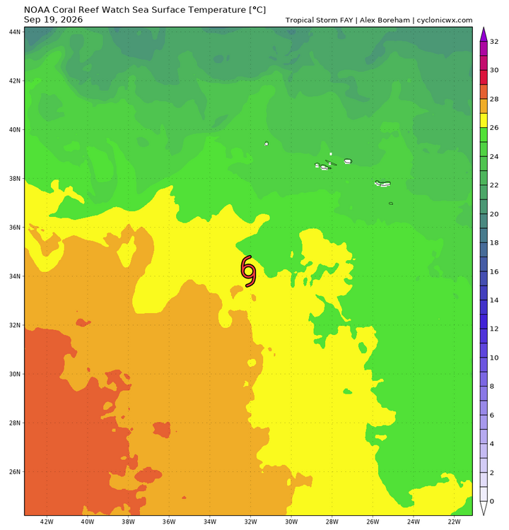
-

2026-2027 Record-breaking El Nino
michsnowfreak replied to Stormchaserchuck1's topic in Weather Forecasting and Discussion
A little OT but the changing of seasons is always exciting. Put the fireplace on today with the autumn chill settling in. Worry about winter if you must, but enjoy Fall everyone! -
Nice. Never hit 70 here.
-

2026 Atlantic Hurricane Season
WxWatcher007 replied to Stormchaserchuck1's topic in Tropical Headquarters
Yeah I think you’re right based on the latest IR. -

Septorcher 2026 Discussion - Endless Summer
powderfreak replied to Damage In Tolland's topic in New England
I whiffed on that post for sure, ha. -

Septorcher 2026 Discussion - Endless Summer
dendrite replied to Damage In Tolland's topic in New England
Hopefully Greta brings palm trees here before I die -
Love the Hurts haters who say he isn't a good QB yet he literally led that team down for the win today.
-
Yeah, went from .35 to 1.10" now. Mod rain
-

Central PA Summer 2026 Discussion/Obs Thread
canderson replied to Voyager's topic in Upstate New York/Pennsylvania
.75” rain today. but the rainy week is slipping away