All Activity
- Past hour
-
Somebody had too much brandy in their eggnog last night
-
Merry Christmas to all. Not much to celebrate on the long range looks at the moment, is there? Oh well
-

26th-27th event, coming at us like a wounded duck.
dendrite replied to Go Kart Mozart's topic in New England
AI. Don’t do it. -
26th-27th event, coming at us like a wounded duck.
dendrite replied to Go Kart Mozart's topic in New England
Merry Christmas weenies
-

Central PA Winter 25/26 Discussion and Obs
Jns2183 replied to MAG5035's topic in Upstate New York/Pennsylvania
You do realize every other model is 4x-5x that? Sent from my SM-S731U using Tapatalk -

26th-27th event, coming at us like a wounded duck.
Kitz Craver replied to Go Kart Mozart's topic in New England
Merry Christmas all! Should be a fun day of modeling -
58 degrees on Christmas morning. Disgusting
-

26th-27th event, coming at us like a wounded duck.
CoastalWx replied to Go Kart Mozart's topic in New England
CJ potential here maybe for an inch or two extra. -

Boxing Night Snow/Sleet/Ice Dec 26-27 Storm Thread/Obs.
Birds~69 replied to Mikeymac5306's topic in Philadelphia Region
Thinking 2-3" snow then crunchy crunch crunch. Not horrible. At least we are tracking something..... Merry Christmas all! 33F -

26th-27th event, coming at us like a wounded duck.
Ginx snewx replied to Go Kart Mozart's topic in New England
Never mind . Nammy but in general its very cold
-
26th-27th event, coming at us like a wounded duck.
CoastalWx replied to Go Kart Mozart's topic in New England
I meant that it may help drive snow a little more NE. -

Central PA Winter 25/26 Discussion and Obs
mahantango#1 replied to MAG5035's topic in Upstate New York/Pennsylvania
Merry Christmas everyone! -
26th-27th event, coming at us like a wounded duck.
CoastalWx replied to Go Kart Mozart's topic in New England
Merry Christmas! -
Merry Christmas to everyone today. I hope everyone has a great Christmas!
-
.
-
26th-27th event, coming at us like a wounded duck.
Ginx snewx replied to Go Kart Mozart's topic in New England
Where what model. -
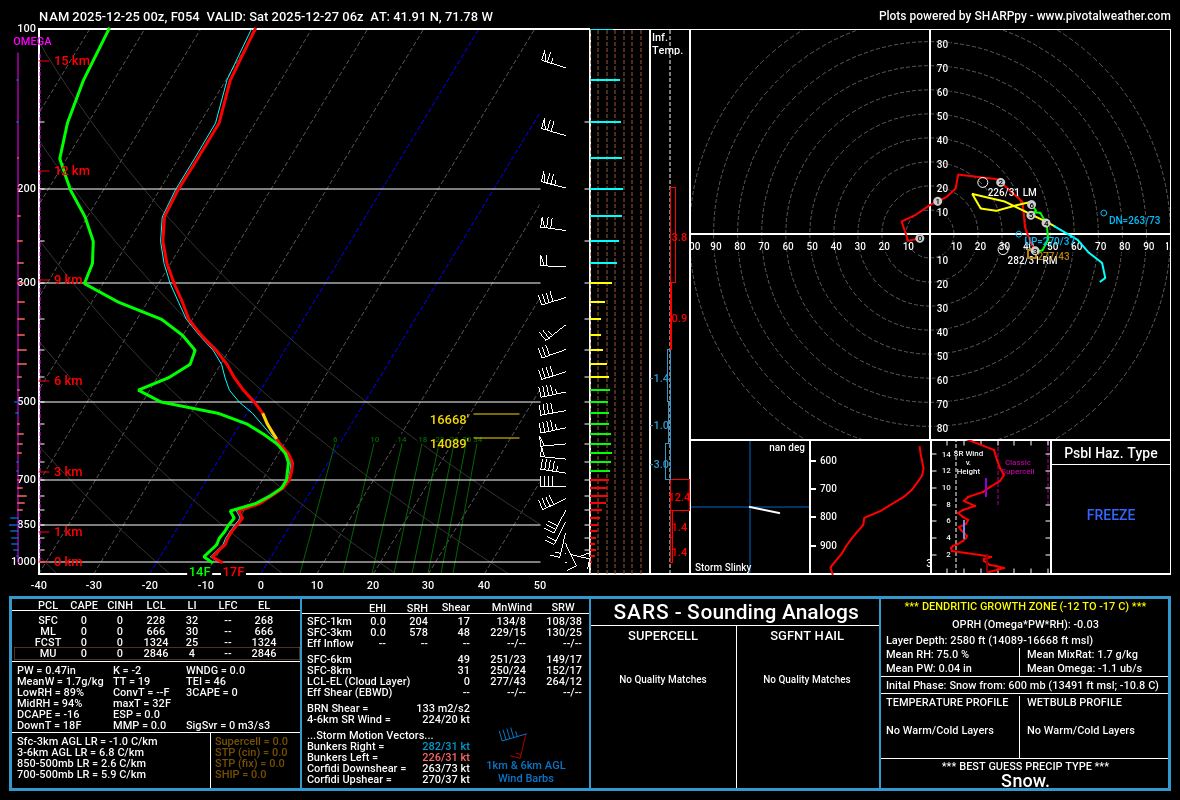
Widespread 60+ dewpoints in developing storm's warm sector, as long as it turns southeast far enough west to avoid flooding low to mid levels in NYC region with 40-45 deg air, I could see this becoming a heavy snow situation for wherever surface temps are closest to 28 F. And that currently looks like ne PA to n/c NJ to NYC and LI. It is a WAA event except that it is going to be rotated around by 45 deg compared to many of them, which I believe will tighten up gradients and lead to a wall of snow outcome. There will be a lot of thunder and lightning across PA into s NJ and n DE during this storm's development phase Friday afternoon-evening. Key point to evolution is that a weak wave tracks e.s.e. across region tonight, reinforcing surface cold and that colder air will flood into the east coast region before the low really reaches full potential, so that will create a fairly resistant cold layer below about 850 mbs. Taint factor may be overestimated for NYC metro by some, but time will tell.
-

26th-27th event, coming at us like a wounded duck.
mahk_webstah replied to Go Kart Mozart's topic in New England
That’s interesting -
From the WPC:
-

26th-27th event, coming at us like a wounded duck.
Damage In Tolland replied to Go Kart Mozart's topic in New England
Yup . Sleet -
26th-27th event, coming at us like a wounded duck.
Ginx snewx replied to Go Kart Mozart's topic in New England
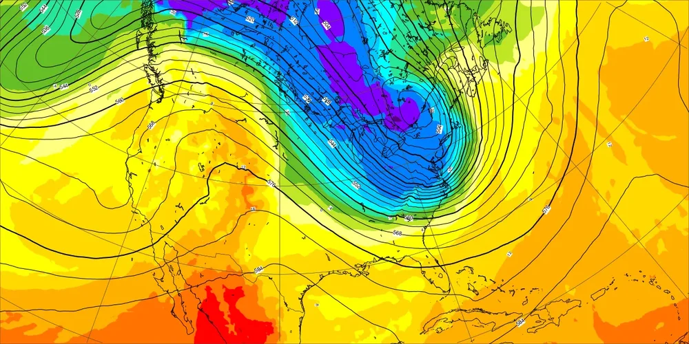
6z Skynet..thumb.png.29f9f3a0b7feb5960751b08618063ba4.png)
-

26th-27th event, coming at us like a wounded duck.
Hoth replied to Go Kart Mozart's topic in New England
Merry Christmas, everyone! Fantastic improvements in the modeling down here. Just hope it's not a head fake. It's been a while since our last 6"+ event. -
Long Island totals are over 6 inches now yet still no watch lol
-
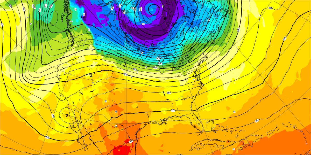
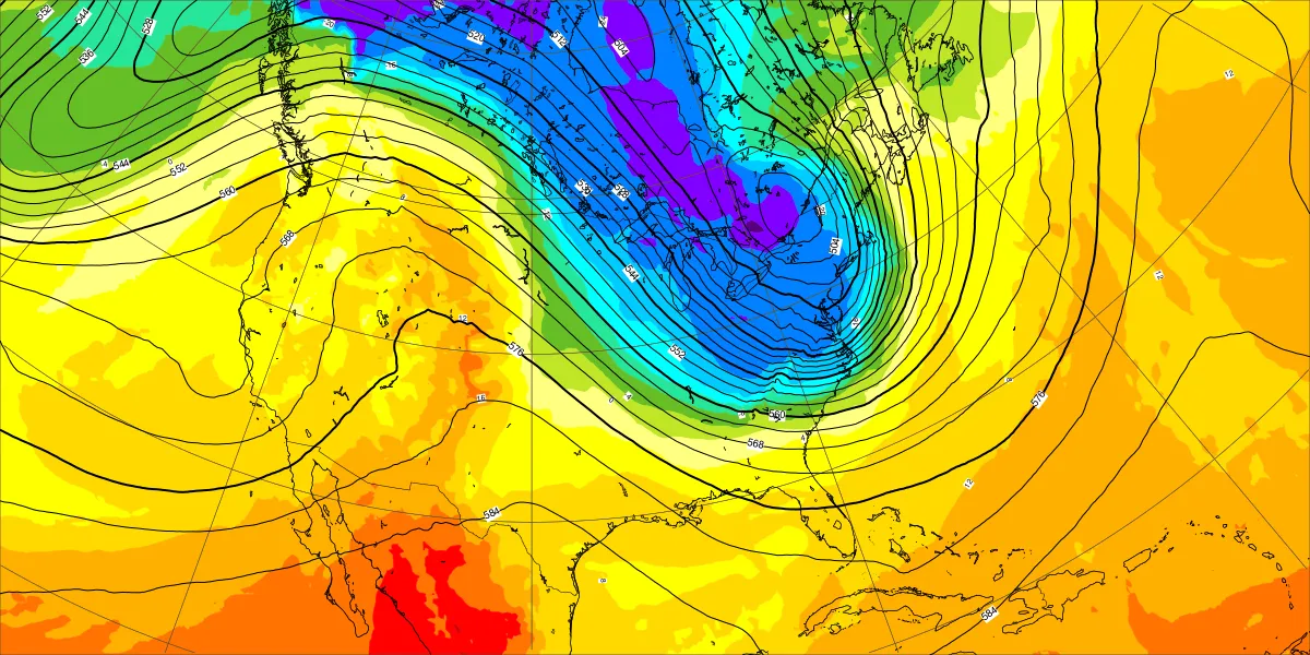
Models not quite as cold for the start of January as prior runs with the core of the cold forecast to stay to our north. New run Old run

-

26th-27th event, coming at us like a wounded duck.
UnitedWx replied to Go Kart Mozart's topic in New England
Merry Christmas everyone! It'll be interesting now to see 12Z, That map from WTNH seems pretty bold still, but would love it to verify.
.thumb.jpeg.f5c6ba9d911ec96b3b124f8606aee58e.jpeg)


.png.2ebb57d0c608be2c5cfdcd09e84883e2.png)