All Activity
- Past hour
-
Thu night into Fri morning
-
The summer of 1980 was an epic furnace, start to finish. Let’s hope not….
-
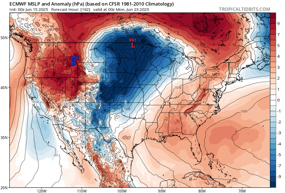
Astonishingly we had similar progression with the signal for the same period, last year which lead to the strong heat in NJ 6/20 - 6/27. The center of the ridge will be key as you detail if those east of NJ continue with the recent tendency for onshore or if its full blast westrlry
-
Forcing does appear to be quite strong with the deepening trough, so at this point it does seem plausible for there to be at the very least some strong thunderstorms around Thursday afternoon and evening. This is supported quite well by the machine learning guidance by UCAR/NCAR which has a targeted area of severe weather potential over the Mid-Atlantic and Northeast. Will continue to monitor for trends in the guidance but regardless, the general idea that a front will bring showers and thunderstorms to the area is consistent with the guidance. Improving weather should return by Friday and into next weekend as high pressure returns.
-
Euro is also in alignment
-
Records: Highs: EWR: 101 (1994) NYC: 96 (1994) LGA: 96 (1988) JFK: 93 (1988) Lows: EWR: 48 (1933) NYC: 48 (1933) LGA: 54 (1951) JFK: 51 (1965) Historical: 1662 - A fast was held at Salem MA with prayers for rain, and the Lord gave a speedy answer. (David Ludlum) 1879 - McKinney ND received 7.7 inches of rain in 24 hours, a state record. (The Weather Channel) 1884: Boston, Massachusetts recorded its highest pressure 30.57 inches of mercury for the month of June. (Ref. NOAA Boston Weather Events) 1896 - The temperature at Fort Mojave, CA, soared to 127 degrees, the hottest reading of record for June for the U.S. The low that day was 97 degrees. Morning lows of 100 degrees were reported on the 12th, 14th and 16th of the month. (The Weather Channel) 1940: A high temperature of 116° at Las Vegas, NV set their all-time hottest June reading. (Ref. Wilson Wx. History) 1953 - Dust devils are usually rather benign weather phenomena, however, two boys were injured by one near Prescott AZ. One of the boys suffered a black eye, and the other boy had two vertabrae fractured by wind-blown debris. (The Weather Channel) 1957 - East Saint Louis was deluged with 16.54 inches of rain in 24 hours, a record for the state of Illinois. (The Weather Channel) 1959: On this day Mt. Mansfield, near Stowe, Vermont, received four inches of snow. (The Farmer's Almanac) 1960: A heat burst struck Kopperl, TX, located about 50 miles southwest of Fort Worth from a dying thunderstorm. As the air sank, it warmed to around 140°. When the heat burst struck the ground, winds fanned out at over 75 mph. People had to wrap themselves in wet blankets to protect themselves from the heat. All crops were destroyed by the heat. (Ref. Wilson Wx. History) 1963: Heavy rain and hail raved parts of the northern Colorado Rockies. In southeast Denver, heavy rain flooded homes and streets. Hail to a depth of 4 inches on the ground stripped trees and drifted in to depths of 3 to 4 feet in places. Flood waters were as deep as 19 feet in places trapping many cars. Many creeks ran over their banks. A cell passed over Denver dropping 4 inches of rain in just 90 minutes. Damage totaled near a million dollars. (Ref. Wilson Wx. History) 1968: Severe thunderstorms brought heavy rain and high winds to much of the western two-thirds of Oklahoma. Winds gusting more than 70 mph dislodged a home from its foundation in Lawton, while winds stronger than 100 mph did extensive damage in Chickasha. The exact wind speed in Chickasha was not determined; because the wind gauge could only measure winds up to 100 mph. Torrential rain amounted to 7 inches in just a few hours near Loyal. (Ref. Wilson Wx. History) 1975: Carlisle, Tex.--An 11-year-old girl was burned to death in a fire caused by lightning. The lightning struck a window air conditioner and the home exploded into a blaze of fire. Another girl was injured. Plymouth, Ind.--Lightning killed a 55-year-old man as he was taking shelter under a pine tree on a golf course. (Ref. Lightning-The Underrated Killer.pdf) 1977: Heavy rains fell for two consecutive days across east central South Dakota through the 16th. Thunderstorms would develop and then move across the same areas repeatedly in what is called a train echo pattern. Rain amounts in the area included 6.9 inches at Watertown, 6.5 inches at Volga, and 7.5 inches at Bruce. (Ref. Wilson Wx. History) 1978: This was a rough day across portions of western and central South Dakota. A tornado touched down in Lemmon then skipped through town causing considerable damage. Numerous severe storms tore through central South Dakota with hail as large as baseballs and winds to 80 miles an hour causing $20 to $25 million dollars in damage across 15 counties. Several counties were declared disaster areas by the Governor of South Dakota. (Ref. Wilson Wx. History) 1986: 91 °F - Heart of June heat wave with 8 of first 16 days 90° or more in Washington, DC. (Ref. Washington Weather Records - KDCA) 1987 - Thunderstorms developing along a cold front produced severe weather in the northwestern U.S. A tornado damaged five homes and destroyed a barn near Salmon ID. It lifted a metal shed 100 feet into the air, and deposited it 100 yards away. Hail an inch and a half in diameter caused ten million dollars damage to automobiles at Nampa ID. (The National Weather Channel) (Storm Data) 1988 - Severe thunderstorms in the Central High Plains Region spawned five tornadoes around Denver, CO, in just one hour. A strong (F-3) tornado in southern Denver injured seven persons and caused ten million dollars damage. Twenty-six cities in the eastern U.S. reported record high temperatures for the date. The high of 97 degrees at Portland ME was a record for June. (Storm Data) (The National Weather Summary) 1989 - Thunderstorms produced severe weather over the Southern and Middle Atlantic Coast States. The thunderstorms spawned eight tornadoes, including strong (F-3) tornadoes which injured three persons at Mountville PA and four persons at Columbia, PA. There were 111 reports of large hail and damaging winds, including wind gusts to 80 mph at Norfolk, VA, and Hogback Mountain, SC. (The National Weather Summary) (Storm Data) 1989: A late-season frost occurred over parts of the Midwest. Scattered areas of frost caused considerable damage to the corn crop in low-lying areas across northern Iowa. Damage was estimated to be around $2 million dollars. The hardest hit counties were in Winnebago, Kosuth and Hancock Counties. (Ref. Wilson Wx. History) 1991: The second largest volcanic eruption of the 20th Century began as Mt. Pinatubo injected 15 to 30 million tons of sulfur dioxide 100,000 feet into the atmosphere. 343 people were killed in the Philippines as a result of the eruptions, and 200,000 were left homeless. Material from the explosion would spread around the globe, leading to climate changes worldwide as the sun's energy was blocked out and global temperatures cooled by as much as one degree Fahrenheit. 1992 was globally one of the coldest since the 1970s.
-
AN as fast as the eye can see starting mid week. Summer is here.
-
Thanks for the link, that's perfect. Do you believe just the Blue Angels would be cancelled or all the other performers? Down at the Hilton on 32nd. Enjoy your time with the family and Happy Father's Day.
-
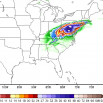
Only thing worse than a Day 2 Moderate is a D5 15%
-
Nice
-
Good Sunday morning, Heat is obviously coming now and interiors slated for an above normal number of 90+ days in June. Thursday may be a heat advisory afternoon for interior NJ (EWR etc). Also mixed layer Cape over 1500J with Bulk Shear >30 kits suggests potential for SVR. Timing timing timing. Then the heat wave, first of the year probably for most of us except water influenced coastal spots (Sunday-approximately around Wednesday of next week), possibly longer with widespread heat advisory conditions early next week, possibly a heat Warning coming for some spots. Interestsingly enough while ML CAPE is high early next week, Bulk Shear is low so any SVR Thunder may be more isolated, local convergence initiated. Recent abo e normal rainfall and another event coming before the heat... that will help with higher dews and possibly lower max temp potential a deg or two. Nevertheless, HOT looks to be on the way.
-
59 / 56 cloudy and cool. 48 more hours in the muck with mainly light showers/rain amounting to another 0.25 at most. Clears out later on Tuesday now and that day looks lost to cooler/cloudy conditions through most the afternoon. By Wed sun returns and it should quickly warm as front comes back north it could trigger scattered storms later Wed. Thu first (2nd/3rd) 90s for many with surge of heat, additional showers/storms Thu night possible. Heat builds north and east by the 20th and into the weed of the 22nd and beyond. 6/14 - 6/17 : Cloudy cool 6/18 - 6/19: warm up (90s on Thu) storms possibility each day in the pm/evening 6/20 - Beyond : Heat builds in - sustained ridging into the east Clouds magnet has reloaded not much in the way of breaks or poked of sun today
-
2.75” across Fri/Sat.
-
Yeah, the 500mb heights and 850mb temperature forecasts would suggest our first 100° of the season would be possible for the usual warm spots. But a wrinkle may be whether the ridge elongates too much into Canada. Notice how the models have a high over Canada and Bermuda. So there could be a subtle backdoor front nearby. If the Bermuda High wins out than the first 100° for places like Newark could be possible. But if the high to the north is too strong, then more onshore flow in later runs east of NYC and perhaps the 100° potential over interior NJ. We probably won’t know for sure until the period gets under 120 hrs out. But we should at least see mid 90s as a floor. And be could get closer to 100° if the ridge is flatter with more westerly flow.
-
Happy Fathers Day to all the Dads! Woke up this morning to pouring down rain. 1.36” of rain yesterday and so far today .11” of rain.
-
Would 1980 be a good analog for what's about to happen? A rainy and cool first three weeks of June (record cool lows on Tony's daily records posts have been from 1980 lately) and an abrupt shift to hot and steamy from June 20th to September 20th. Although the epicenter of the big heat was St Louis that year, NYC had their hottest ever 62 day couplet (July-August) with both months averaging 80 or higher and August 1980 was our hottest August on record!
-
Finally! It's about time! Would 1980 be a good analog for what's about to happen? A rainy and cool first three weeks of June (record cool lows on Tony's daily records posts have been from 1980 lately) and an abrupt shift to hot and steamy from June 20th to September 20th. Although the epicenter of the big heat was St Louis that year, NYC had their hottest ever 62 day couplet (July-August) with both months averaging 80 or higher and August 1980 was our hottest August on record!
-
Low of 59F. 0.30” of rain last night and overnight. .
-
The strong subtropical warming actually contradicts our current understanding of how the ocean temperatures have changed in the past. The strongest SST warming was expected in the subpolar oceans. But instead the western subtropical basins have seen the greatest warming. But isn’t anything new as the lack of warming in the EPAC has baffled scientists for a while now. https://www.nature.com/articles/s43247-023-00839-w Strongest ocean warming expected in subpolar ocean The observed warming pattern (Fig. 1a) contradicts our understanding of how ocean temperature has changed in the geologic past. SST reconstructions covering the mid-Pliocene, the most recent time when atmospheric GHG concentrations were similar to today41, highlight the strongest large-scale ocean warming over the subpolar oceans (Fig. 1c). Comparably, warmings in subtropical regions are less pronounced, except for the subtropical extension of western boundary currents, where a poleward shift of western boundary currents contributes to a local maximum temperature increase8,9.
-
Midnight thunderstorm dumped over 1.5" of rain here. 2.05" for the weekend. 3.65" for June so far.
-
We have been in a very rainy, cool pattern since the last week of March. That looks to come to a real abrupt end next week as the pattern does a 180
- Today
-
Look up KOXB TAF, it gives you cloud heights for the ocean city airport. It was canceled after basically two flights. Today doesn’t look good at all. Need at least 3000 foot ceiling and it’s calling for 1000 all day. I am on 17th street holiday inn and suits ocean front. Have me wife and two boys as well.
-

Central PA Summer 2025
Mount Joy Snowman replied to Voyager's topic in Upstate New York/Pennsylvania
Low of 59 with .3” of rain. Heading out for a little father’s day golf outing here in a bit and it looks like we may actually stay mostly dry. -
Day 5 outlooked from SPC
- 1,027 replies
-
- 1
-

-
- severe
- thunderstorms
- (and 2 more)
-
Tonight looks fairly cool, but yeah…it’s comin. Maybe a mild down toward next weekend…then the ridge tries to really build back in. There is a bit of a BD threat to start the following week…may have to watch that over the next few days.