All Activity
- Past hour
-

December 2025 regional war/obs/disco thread
40/70 Benchmark replied to Torch Tiger's topic in New England
-
That wasn’t my point. I was responding to Don’s post that the GEFS is insistent on a +EPO pattern taking hold the 2nd week of December, which it clearly is. It’s putting a huge vortex over Alaska and has been for several runs in a row
-
it dosent even change over rain like 30 feet from my house
-

E PA/NJ/DE Autumn 2025 Obs/Discussion
RedSky replied to PhiEaglesfan712's topic in Philadelphia Region
Euro op runs the rain/snow line near route 202 -
Nah, wet snow is good to measure.
-

December 2025 regional war/obs/disco thread
SouthCoastMA replied to Torch Tiger's topic in New England
If things don't break right this year, there's always this option -

Nov 28-30th Post Turkey Day Wintry Potential
michsnowfreak replied to Chicago Storm's topic in Lakes/Ohio Valley
Still looks like a solid snowfall. Very solid November. -
Ooof. Need 5-10 miles please lol
-
 That result has happened many times. In addition, up on top of Storm King Mountain, is an even snowier outcome. And all are within a 5 mile radius.
 -
EURO also has a big storm wayyy out there Dec. 10 or so.
-
If the canal gets more than here, every single Christmas decoration is burnt.
-

Pittsburgh PA Fall 2025 Thread
Mailman replied to TheClimateChanger's topic in Upstate New York/Pennsylvania
First respectable snow within five days, it seems. -

-
Nov 28-30th Post Turkey Day Wintry Potential
michsnowfreak replied to Chicago Storm's topic in Lakes/Ohio Valley
Not that last year was a banner year here (29.5") but you got so screwed im happy for you to be in the jackpot -
December 2025 regional war/obs/disco thread
40/70 Benchmark replied to Torch Tiger's topic in New England
-
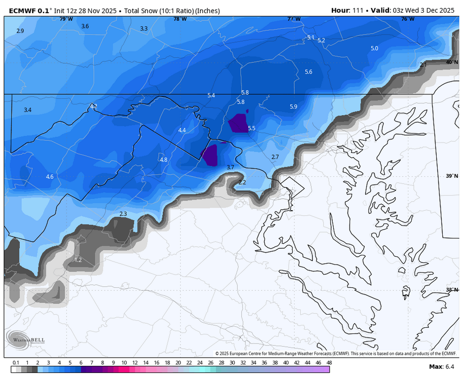
For posterity - snows on the front and backend.
-

December 2025 regional war/obs/disco thread
HoarfrostHubb replied to Torch Tiger's topic in New England
Cory should love the Euro -
Nov 28-30th Post Turkey Day Wintry Potential
michsnowfreak replied to Chicago Storm's topic in Lakes/Ohio Valley
Trends aren't bad at all. -

Nov 28-30th Post Turkey Day Wintry Potential
SolidIcewx replied to Chicago Storm's topic in Lakes/Ohio Valley
Gonna be interesting to see the variations in storm totals from west to east in the Detroit Metro. -
December 2025 regional war/obs/disco thread
HoarfrostHubb replied to Torch Tiger's topic in New England
And then you'll run uphill with a ruler and yell at the crew doing measurements -
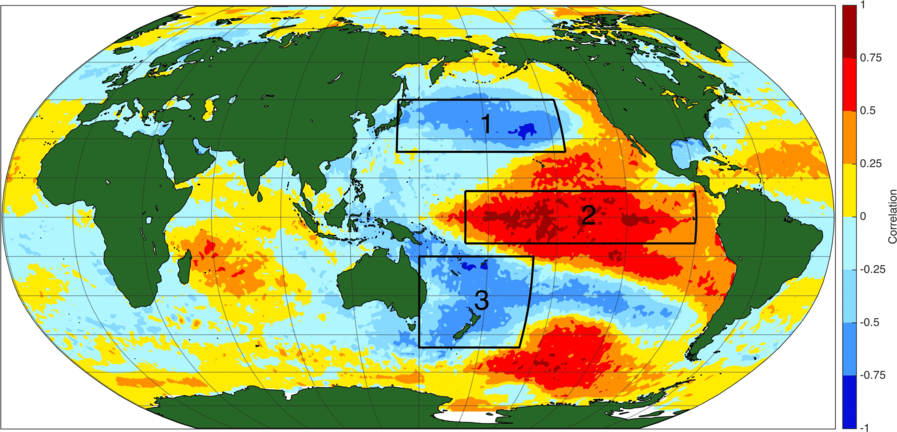
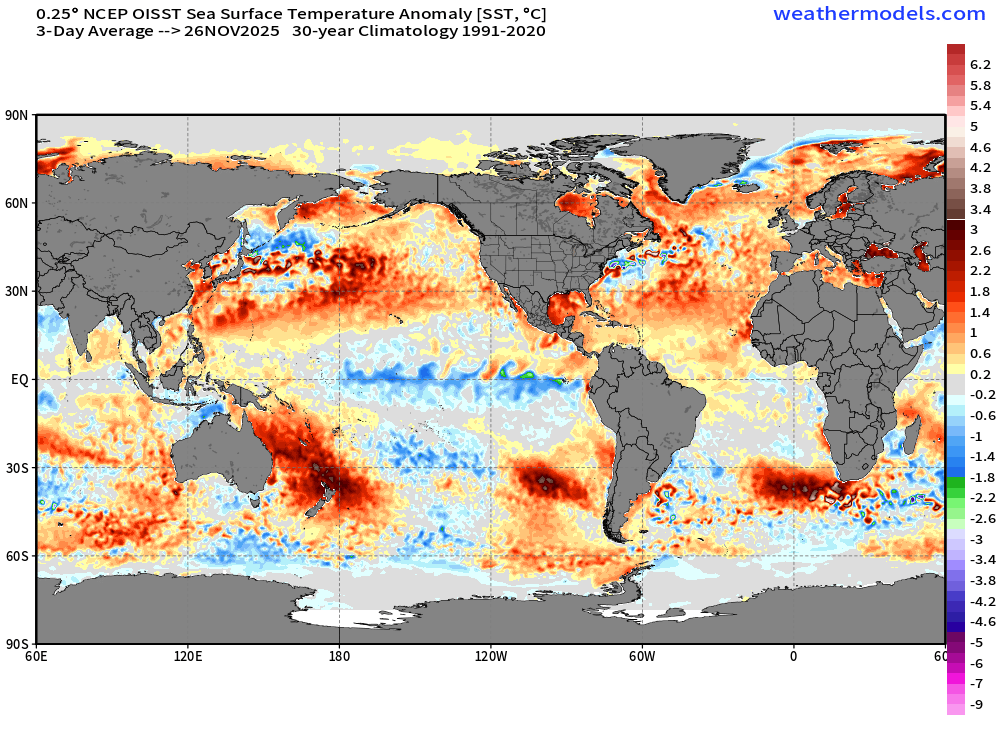
There is, perhaps, something else to consider in the context of that. The IPO or Interdecadal Pacific Oscillation. Being an interdecadal phenomenon, it operates on timescales of multiple decades. This complicates matters. It's easy to perceive something potentially spanning over a decade as being permanent. It also encompasses the entire Pacific basin. Whereas features such as Enso and the PDO are more geographically focused and can fluctuate within the greater framework spanning multiple decades. There's a lot to read out there on the topic. 1st image below is from the NOAA Physical Sciences Lab showing the positive phase of the IPO and associated tripole signature. Interestingly, there have been some research done suggesting links between the record 2019-20 Australian wildfires and the IPO. Perhaps enhancing a negative phase along with playing a role in our most recent triple dip la nina event. By altering cloud physics. 2nd image is what we have currently. Showing a pretty clear -IPO on going to this day. One day this will shift again. My guess is that we'll see the marine heatwaves that we hear about shift as well when that happens. +IPO: Current conditions:
-
Can we please reel this in? Maybe by tomorrow I’ll start to believe it a little. Maybe..
-
Maybe I’ll go to MQE and just sit nude in the watch tower.
-
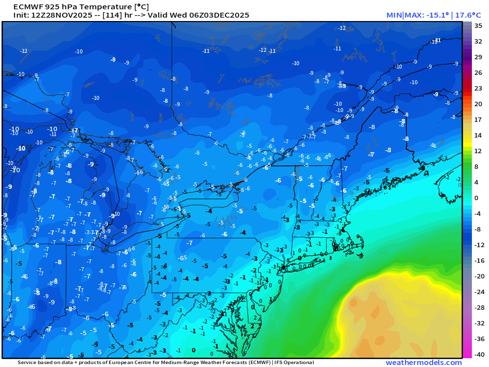
It actually cools a bit during the "CCB" portion of the storm
-
December 2025 regional war/obs/disco thread
SouthCoastMA replied to Torch Tiger's topic in New England
do it for a few hours, ride the high, then come crashing back to earth at 18z.


