All Activity
- Past hour
-

July 2025 Obs/Disco ... possible historic month for heat
kdxken replied to Typhoon Tip's topic in New England
Perfect outside except now the mosquitoes are coming out. Good night! -
July 2025 Obs/Disco ... possible historic month for heat
kdxken replied to Typhoon Tip's topic in New England
Sure is when the temperature is 74 lolz -

July 2025 Obs/Disco ... possible historic month for heat
HoarfrostHubb replied to Typhoon Tip's topic in New England
Yeah. Pretty dewy out there tonight. I ain’t gonna lie. -

July 2025 Discussion-OBS - seasonable summer variability
TheClimateChanger replied to wdrag's topic in New York City Metro
A couple locations in far northern New York weren’t far from reaching record lows and record highs on consecutive days. Massena tied a record low of 47F yesterday, but fell 2F short of today’s record high. Plattsburgh missed a record low by 1F yesterday and missed a record high by 1F today. -

July 2025 Obs/Disco ... possible historic month for heat
Damage In Tolland replied to Typhoon Tip's topic in New England
Interesting now that dews are 65-70.. that’s nice cool comfy evening. My how ACATT has evolved -
Highs: EWR: 92 TEB: 90 PHL: 90 New Brnswck: 89 NYC: 87 LGA: 87 TTN: 86 JFK: 85 * readings back to normal ACY: 85 ISP: 84 BLM: 81 * missing readings / no intra hour highs
-
Mid Atlantic surf zone and offshore SSTs are on fire compared to last year at this time.
.png.637922cb7c33ef783affb04216372f54.png)
-
Getting some consolation showers. Picked up 0.13".
-

July 2025 Discussion-OBS - seasonable summer variability
SACRUS replied to wdrag's topic in New York City Metro
Highs: EWR: 92 TEB: 90 PHL: 90 New Brnswck: 89 NYC: 87 LGA: 87 TTN: 86 JFK: 85 * readings back to normal ACY: 85 ISP: 84 BLM: 81 * missing readings / no intra hour highs -
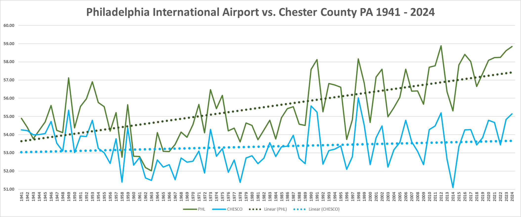
 Which of these things is not like the other??? Can we say UHI contamination??? Wonder why we only show PHL on the local news???
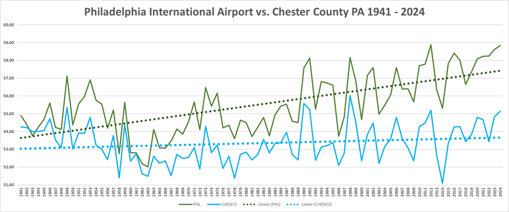
-
Very impressive heat in southeast Lower Michigan today. Selfridge Air National Guard Base reached 98, its highest reading since 2012. 97 at Troy, Pontiac, and Ypsilanti (Willow Run). Flint and Coleman Young Airport topped out at 96. Detroit Metropolitan Wayne International Airport and Ann Arbor Municipal Airport both reached 95. Monroe reached 96, and even the traditional cool spot at Grosse Ile topped out at 95. Wonder what @michsnowfreak observed today? Looking at some backyard thermometers around Wyandotte, it looks like 97-98 was pretty common. Definitely a scorcher!
-
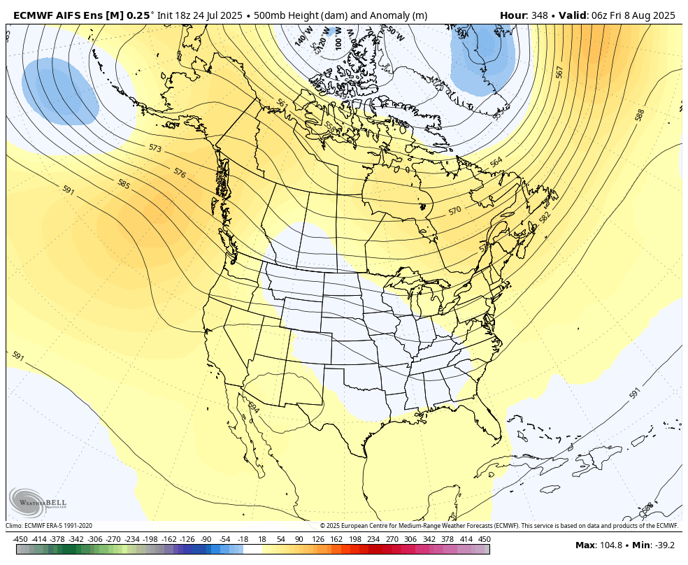
WB 18Z EURO AI Ens. at Day 14

-

July 2025 Obs/Disco ... possible historic month for heat
DavisStraight replied to Typhoon Tip's topic in New England
Great night for a walk with the pup, nice breeze kept me cool. -
Peaked at 92° at ORD and 96° at MDW today. ...2025 90°+ Day Tally... 20 - ORD 20 - DPA 19 - MDW 19 - PWK 18 - ARR 17 - LOT 15 - RFD 11 - UGN
-
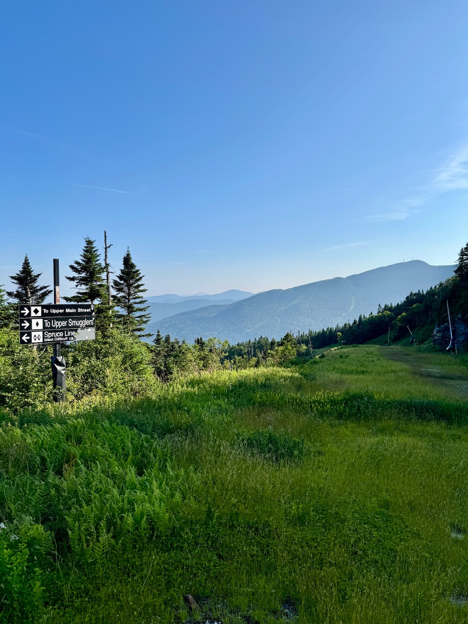
Jesus sky meadow! Haven't played that since it was a public course.
- Yesterday
-
July 2025 Obs/Disco ... possible historic month for heat
kdxken replied to Typhoon Tip's topic in New England
Yeah wrap this evening up in a box and save it until we need it. 77/66 with a nice breeze. Just about perfect evening weather. -

July 2025 Obs/Disco ... possible historic month for heat
powderfreak replied to Typhoon Tip's topic in New England
Warm day. Locally, MVL hit at least 89-90F in the valley. It’s alarming how comfortable it felt with dews only in the mid-60s instead of low to mid-70s. We are moving goalposts rapidly now after the heat/humidity so far this summer. Mid-60s dews feel not so bad. Was low-70s above 3Kft. Really nice evening up high.
-

July 2025 Discussion-OBS - seasonable summer variability
doncat replied to wdrag's topic in New York City Metro
No measurable rain here for 10 days, but that was after a 2.91" deluge on day 11. -

July 2025 Discussion-OBS - seasonable summer variability
Dan76 replied to wdrag's topic in New York City Metro
Tell that to my lawn. -
Got a solid squall line quickly move through, 19th storm of 2025. 9mm in 35 mins, 230 strikes all CC. Finally saw a shelf cloud and fantastic hues of blue. What might be the most impressive part was how dark it got at 5:30, 100 lux!! 34C/93F for a high, windy again. I didn't find it all that humid but there was a humidex of 43. I enjoyed it and made an effort to be outside to take it all in.
-

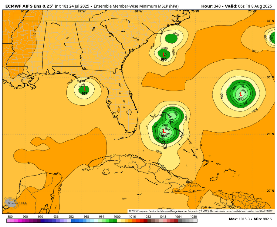
2025 Atlantic Hurricane Season
Torch Tiger replied to BarryStantonGBP's topic in Tropical Headquarters
Yeah I was thinking 8/10-20 ish as the first "burst" of activity as well, but if you asked me back in May I would have said early August. -
July 2025 Obs/Disco ... possible historic month for heat
kdxken replied to Typhoon Tip's topic in New England
Those poor folks in Connecticut. Bradley international reached an unheard of 87°! -
July 2025 Obs/Disco ... possible historic month for heat
kdxken replied to Typhoon Tip's topic in New England
Anyone know where the closest cooling station is to Worcester? Heat index got up to 86 today! Even with the stiff cooling wind it's become unbearable. -

2025 Short Range Severe Weather Discussion
nwohweather replied to Chicago Storm's topic in Lakes/Ohio Valley
Looks like the OH/MI border is going to get some solid boomers. More instability and heat this way as well -

2025 Short Range Severe Weather Discussion
sbnwx85 replied to Chicago Storm's topic in Lakes/Ohio Valley
While I was at work, I watched a big storm on radar go over my house. Lots of CG, too. I'm sure my dogs will tell me all about it when I get home.