All Activity
- Past hour
-

2025-2026 ENSO
PhiEaglesfan712 replied to 40/70 Benchmark's topic in Weather Forecasting and Discussion
2018-19 was a nearly identical winter to 2016-17. Both were C to C- winters, with a lot of nickel-and-dimers, but no real snowstorm. Both are notable for having their most notable storm outside of the DJF period (18-19 in mid-November, and 16-17 in mid-March). 18-19 did have its moments of cold (November and March were well below average, and DJF was only about +1, +2 above average), while 16-17 was a blowtorch pretty much all winter (with the exception of March). -

E PA/NJ/DE Spring 2025 Obs/Discussion
RedSky replied to PhiEaglesfan712's topic in Philadelphia Region
Thank the gods we can still get record cold crap days in the best month of the year while the rest of the year/world warms inexorably onward -
It barely gets below 996 mb ... ha. I get the enthusiasm for weather events and applaud that, but... she ain't no tempest. It's really just a perfect timing of large scale synoptics that takes a piece of shit low and enables it to seriously f-up almost 3 consecutive days. Welcome to spring in New England
-
It's been drizzling pretty hard for several hours but not showing on radar. The precip on radar west of DC looks pretty nice. It looks like a wet evening.
-
Nice little tempest. Where was this in February? 8-12" on the Rockpile!!

-
BDL at 3.71? I thought the big totals were going to be on the coast.
-
I think by now you know not to take anything I say to ❤️. I spend winter in a tropical climate when its zzzz. I do travel back for snow which is in its own right may be considered to some as sick in the head. I dont recall a pattern like this for this long 6+ days in late may. Luckily it looks to dry out for the weekend for movement in hart plaza..
-
yeah, wtf ... 2005 had 3 nor'easters spanning 2.5 weeks from the 10th to the end of the month. Each was below 995 in depth ...I remember. That product Ben used says ERA5; wonder about that source.
-
Sweet merciful hallelujah the Orioles back in the win column
-
I've played it. The conditions were brutal the day I did. Howling winds and and soaked fairways. Hard to give an honest assessment.
-
Back into drought? lololol there has been no drought
-
I think both public and private. He's up to 145 and he started in 2020 . He films them and does reviews that's his business model. Might find out a little more on his Instagram I don't have Instagram so I can't see. https://www.instagram.com/reel/DEQ3st7Ruq8/
-
depends on the type of structure too-older houses with an exposure to wind-forget it-the heat gets sucked out quick. Apartment buildings or newer houses different story
-
the wind..... heat needs to be on for any temperature below 60 and no sun it should be mandatory by New York law
-
Also what about 2013?
-
Some healthy convective cores shown by several CAMs tomorrow afternoon. They’ll be quick hitters, but they should be interesting.
-
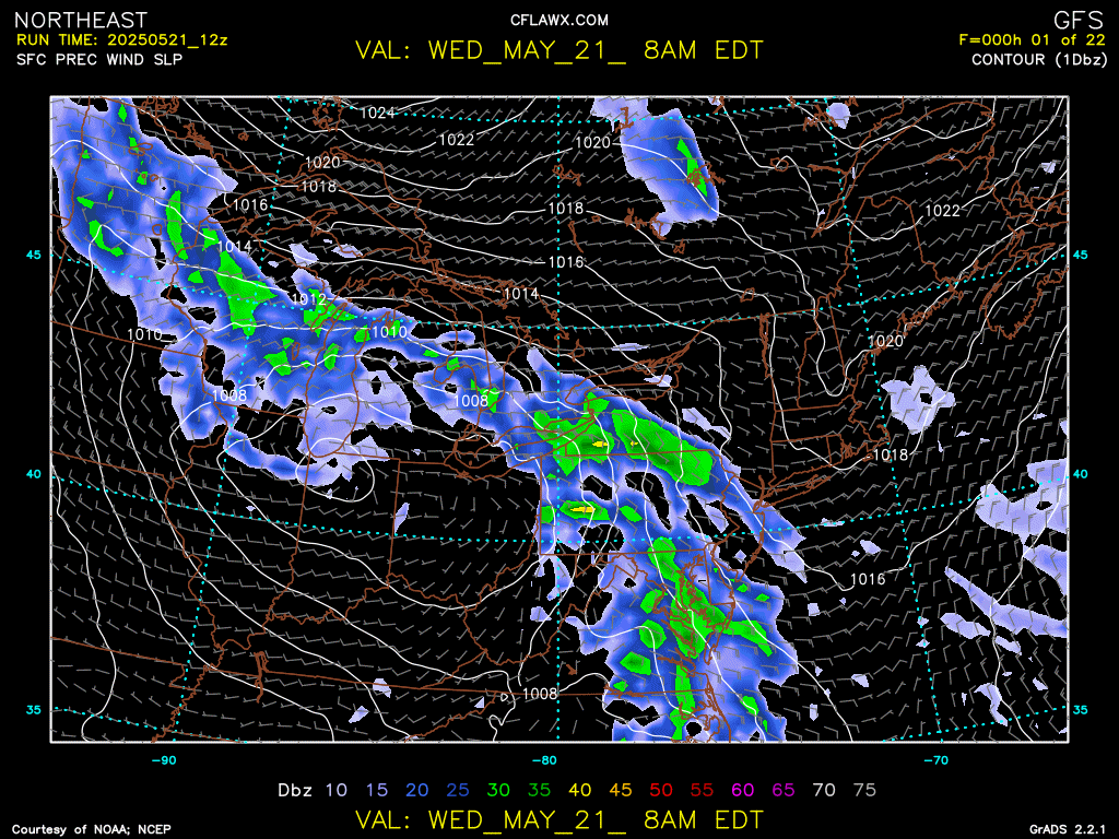
RGEM east with the big rains over RI, NAMS and Euro west over CT/LI/NYC
-
Big differences in the models for precip totals and location of QPF max just like a winter nor'easter. NAM goes absolutely bonkers @ BDL with 3.71" on BUFKIT. GFS only around 1.5" and the HRRR about 1". Who will win? Oh and the Euro is about 1.8" with the QPF max farther southwest towards my area and southwest of there. Euro and NAM kind of look similar so perhaps the old "EE rule" will be in effect?
-
Today yes but after a night of rain and wind and all day tomorrow- may need it.
-
Hmm, well having spent a miserable spring and summer in Little Rock I guess I can understand why you prefer this lol
-
I agree!
-
I can’t read article because it’s the globe, is he attempting to do in 1 year? Public only? Public and private?
-

2025-2026 ENSO
Stormchaserchuck1 replied to 40/70 Benchmark's topic in Weather Forecasting and Discussion
We have been getting -EPO's, and even -PNA's can deliver big cold shots. There have been a few cases of good -AO's too with 500mb ridging over the Davis Strait and Greenland. Lack of clear +PNA and -NAO is why the SE ridge has persisted and storm tracks have not been benchmark. There have been I think 3 Winter months of +PNA/-NAO since 2016 (when it should happen 1/4 times). We did get +PNA/-NAO for the first 2 weeks of January in 2025, and it did give DC an 8" snowstorm. The reason it didn't hit further north was a lot because of a "Moderate Nina-like" STJ. Because of these indexes the cold has not spread east, and has been confined to the Midwest. They have had some impressive cold shots in the Midwest though. When the global temp is +2F higher, the cold is not going to be as widespread, but the indexes have been a large part of the problem, especially wrt snowfall. +PNA/-NAO is 5x more likely to give a benchmark storm track than -PNA/+NAO. -
I do! I had to do quite a bit of walking today and the weather is just perfect for that. No sweating, no sun in my eyes. Also, it feels amazing in my apartment and I'll be sleeping under covers tonight (as I have been the past couple of nights). All of that makes me happy. Not looking forward to the walking I'll have to do when it gets warm/hot. This weather happening in late May is a blessing to me.
-
I wish. Thermostat was at 65 this morning. Old house ftw