All Activity
- Past hour
-

January 2026 regional war/obs/disco thread
40/70 Benchmark replied to Baroclinic Zone's topic in New England
Pacific trough says what's up, b1tches..... -
I remember being out in Stony Brook a few days after this storm. While I thought I got crushed at home, when I got out there it was like 150% of what I'd gotten, just crazy. And that was a day or two afterwards. Some crazy gradients, right?
-
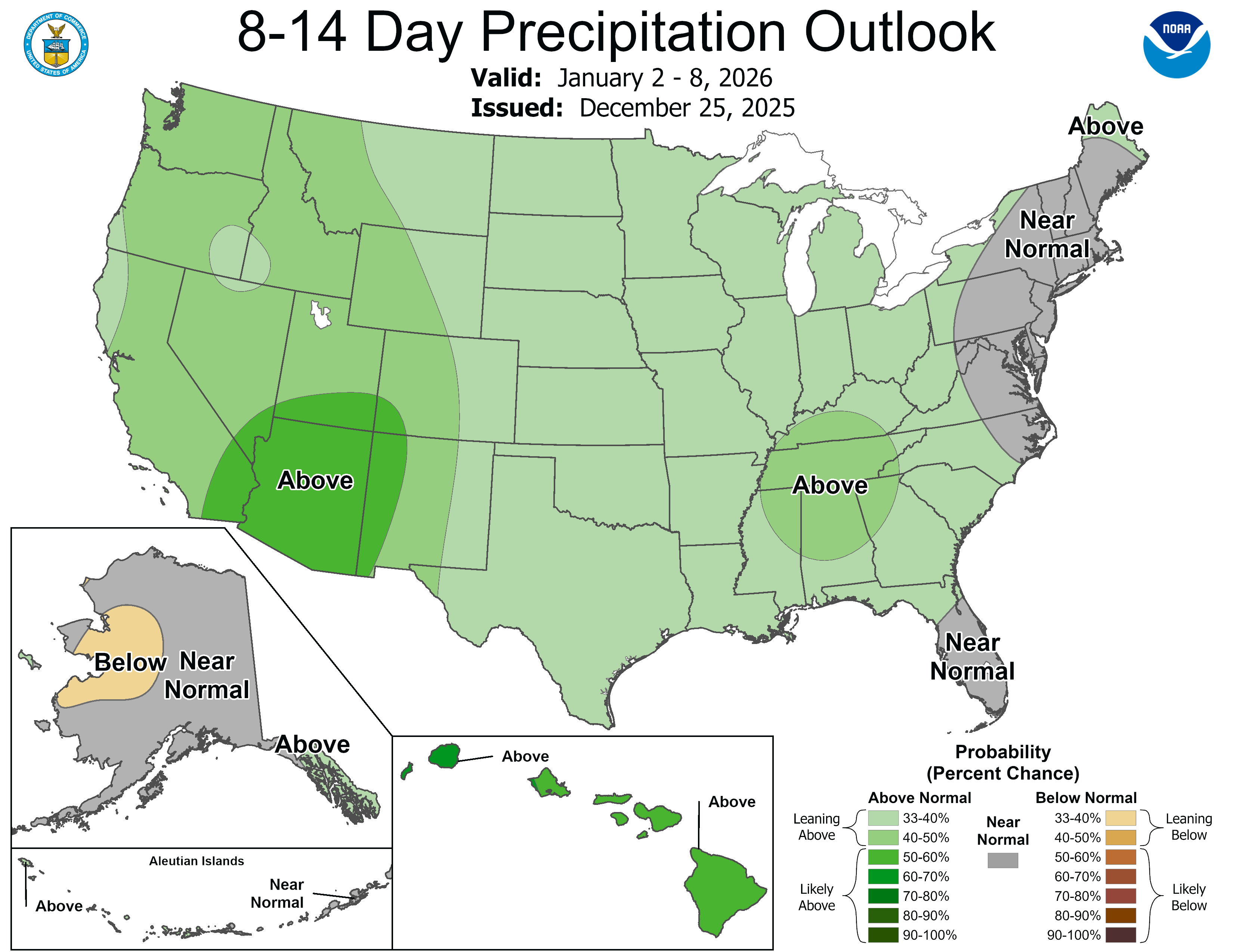
2025-2026 ENSO
40/70 Benchmark replied to 40/70 Benchmark's topic in Weather Forecasting and Discussion
@GaWxLarry, it has that El Niño look because of the Pacific airmass....that is what I tried to capture in my January composite....pretty similar look with months like January 2006 and 2002 in there. -
Over 50? Yes it is..
-
January 2026 regional war/obs/disco thread
40/70 Benchmark replied to Baroclinic Zone's topic in New England
Yet BOX tossed my March 2018 measurement....asses. -
Nice line of storms hitting from the southwest. Tornado warning in Shelby County. Winds are getting after it right now here
-

E PA/NJ/DE Winter 2025-26 Obs/Discussion
snowwors2 replied to LVblizzard's topic in Philadelphia Region
29.5° as of 9 PM -
Can't help but recall this shtick

-
Was hoping we’d hit 60 in Chicagoland. It’s gonna be close. .
-
Is that a technical term?? Lol
-
as some would say, buckets+++.
-
Swirlie thing?? Lmaoooo
-
Surprised nobody has whined about wasted QPF.
-

January 2026 regional war/obs/disco thread
Torch Tiger replied to Baroclinic Zone's topic in New England
brutal. Yeah I know there is always questionable if not bad data, but there it is so obvious it should not exist. Lol -
The PV will control that spacing. The models want to send in south. If that happens we are in the game. If it doesnt we are done. That is the bottom line.
-
Salt gone.
-
there was a spc update earlier today and slight risk is now south of us into mississippi and portion of alabama and us and possibly kentucky in marginal and general thunder risk i didnt really think its worth posting since a new day 1 outlook will be posted tomorrow morning at 1 am
-

January 2026 regional war/obs/disco thread
dendrite replied to Baroclinic Zone's topic in New England
There’s a lot of bad COOP data out there. I assume they just gave the observers the benefit of the doubt in most cases. -
Those are COMICAL given reality!
-
Lol bulls rain delay
-
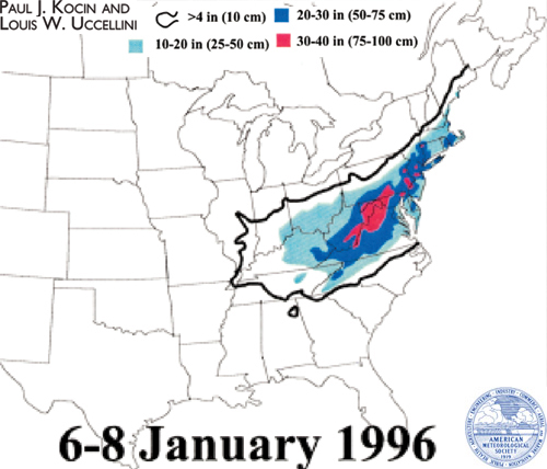
That map for 96 is atrociously wrong btw. The KU map is much better.
-
Not very often you see 60s in the sub in January, but here we are. 61 in Champaign, and a quality soak. Looking forward to a much needed pattern change.
-
That said, I think the south metro like Castle Rock and Parker may do ok tonight.
- Today
-
We've had some, they just haven't panned out.


-
January 2026 regional war/obs/disco thread
Torch Tiger replied to Baroclinic Zone's topic in New England
why are they official obs? (if so)