All Activity
- Past hour
-
Got .02” from that one - puts me at .12” for the weekend and I’m curious if that is it. Last I looked Sunday afternoon was kinda falling apart.
-

E PA/NJ/DE Summer 2025 Obs/Discussion
LVLion77 replied to Hurricane Agnes's topic in Philadelphia Region
Quick 1/4” of rain from this line of showers and tstorms. Already sunny again! . -
Afternoon day 2 disco from SPC ..South to Lower Mid-Atlantic States... Boundary-layer heating is anticipated along the Atlantic Coastal Plain and adjacent Piedmont should support MLCAPE of 1500-2500 J/kg. Multiple embedded MCVs will support at least scattered afternoon storms developing near the higher terrain and spreading east towards the coast. Enhanced mid-level westerlies will support transient/weak updraft rotation and multicell clustering. Scattered damaging winds and isolated severe hail are likely. A couple of tornadoes are also possible in the Lower Mid-Atlantic along the primary differential heating corridor, where low-level shear may be adequate ahead of a central Appalachians MCV.
-
Hmmm... let's try again tomorrow? 15 wind and 5 tor
-
The air......she has changed. Breezy and much less humid since the front passed through.
-
Absolute downpour again, might get me over an inch.
-
Yep, nothing heavy and it will be all finished before sunset and the sun could even peek out around 7 this evening. It might be a nice sunset. I hope you feel better JM, bugs suck, but especially this time of year.
-
And partly wet. With more to come. How is that defined as a saved afternoon? Saved from what?
-
I'm sick today anyway with the bug that's been spreading around my office. So whatever. Light steady rain here which is what it looks like we'll have for the next hour or so.
-
If you actually looked at the radar loop you'd see that, pal. But that's asking a lot
-
Its been mostly dry
-
Muggy out there. Went up to Glen Rock for their arts and brew fest and was sweatin’
-
Good call Chief. How's your cookout going?

-
You're lucky it's been raining here for hours. This blows.
-
Can't wait, checked out the video and there are surfers out there presently getting some good wave action, as mentioed below the tide is coming in with a peak high tide in Southern NJ at 5:30 to 6:20 PM today. Surf zone summary : Fun-size SSE swell has built in this afternoon. Patchy fog but fun chest high waves. Low pressure tracking through the Northwest Atlantic sets up a fun pulse of mid period swell that moves in and peaks this afternoon That offers surf in the chest high range with some bigger sets likely at top spots as the tide pushes in. Shape generally looks pretty fun but parts of Ocean County still are dealing with fog and low visibility. Winds look light most of the day setting up pretty clean/manageable conditions. Make the most of it. https://northwildwood.com/north-wildwood-surf-cams/
-
Incoming. Just in time for a soccer game.
-
One of those years.
-
This guy has some time to cut some trees for you now.

-
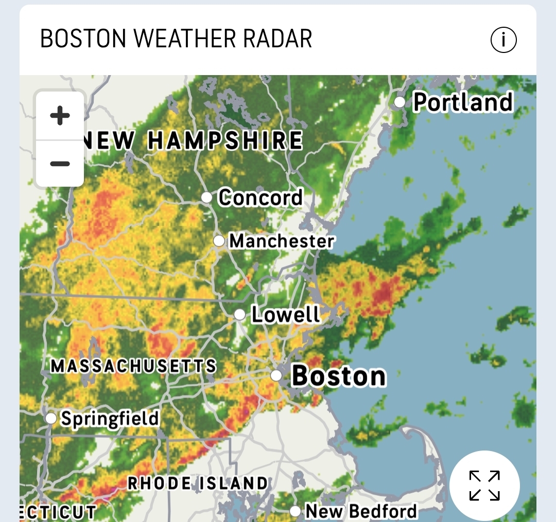
I know that because of our tree blockage issues that trips the rain rate algorithm over to a special attenuation version, BUT it only works below the freezing level. So everything above the freezing level is suspect at best. So for any precip accumulation product that's a factor for us. I'm confident someone right now is working on the contract to get our radar raised to mitigate the issue.
-
I notice it a lot in winter when there’s a band at 30dBZ over S NH on GYX and BOX has it pushing 35-40. With that said, GYX looks a little light compared to ENX and CBW too right now, but it’s tough to make on a whim comparisons. You would know better than me.
-

June 2025 discussion-obs: Summerlike
WestBabylonWeather replied to wdrag's topic in New York City Metro
Hey guys know how I know it’s Saturday? -
and neither is a good chunk of June...
-
Drove up Rte 146 Deluge rains most of the ride. And then again as we got home. 1.0” so far after 1.25” yesterday
-
The good news is May isn't summer haha
-
we had some sunshine here earlier (you can see the break in the clouds over Long Island.)