All Activity
- Past hour
-
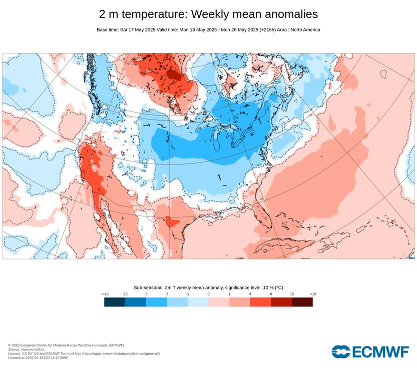
Spring has been well above normal thus far. CC can cause cutoff lows due to the anomalous blocking. The rest of the country is torching. We're the island in the ocean of warmth.
-
Definitely a gradient between you and SoP.
-
Elon broke it
-
Vis satellite insn't offering a lot of confidence in the sun here. It's possible but the clearing may stall southwest of here. At least it's not raining and foggy. Spring is the season that doesn't take place in coastal maine.
-
Gfs is unusable.
-
I’m talking about next week.
-

2025-2026 ENSO
Stormchaserchuck1 replied to 40/70 Benchmark's topic in Weather Forecasting and Discussion
Not really a big deal imo. The PNA has been negative, and the NAO has been positive. There's a +1-2 global warming happening but that's the everything -
That Midwest warmth in March 2012 was more historic than the cold in 2015 was. The few months with -10 or more departures the CONUS since 2015 have been few and far between compared to the months over +10. This is a CONUS wide phenomenon and not just limited to one region. You can see how getting a +10 month nearly every winter since the 2015 higher temperature reset has become the norm while extreme cold is very isolated to places like Montana. Plus our Arctic outbreaks have shrunk the geographic footprint. So an Arctic outbreak into the Plains doesn’t extend all the way to the coast like it did as recently as the 1990s. Dec…2015….NYC….+13.3 JAN…2017….BTV…..+11.0 FEB….2017….ORD….+10.3 FEB…..2018…ATL….+10.6 FEB….2019…MGM….+10.5 JAN….2020…YAM….+9.8 DEC….2021….DFW….+13.2 JAN….2023….DXR….+12.3 FEB….2023…..SSI…..+9.8 DEC….2023….INL…..+15.8 FEB…..2024….FAR…..+17.5 DEC….2024…..LND…..+11.3
-
Even your beloved AI has come SE somewhat . Enough that is delivers a fairly solid weekend
-
I know most of you will enjoy it, but I wonder if what we're seeing will be the general theme of the entire summer. In my highly uneducated theory, the pattern that developes in May seems to carry through most of the summer season. Just as you guys like your winters to be winters, with cold and snow, I like my summers to be actual summers, with generally warm to hot days, broken up by occasional late day thunderstorms.
-
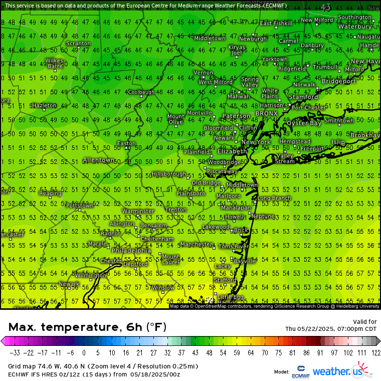
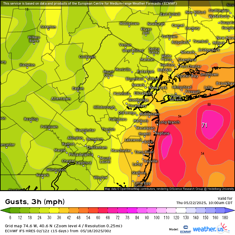
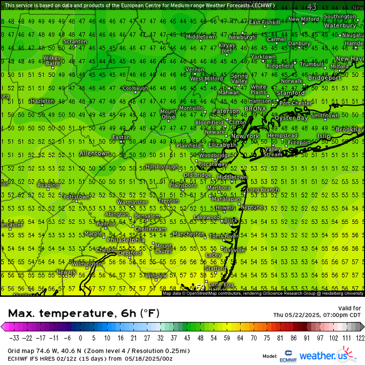
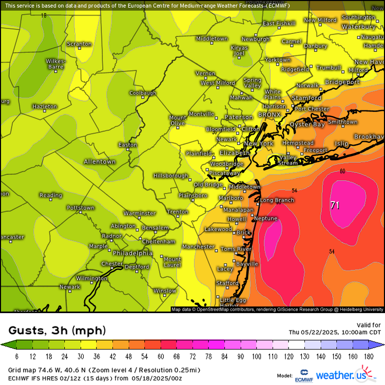
Could be the best Noreaster of 2025 this week. While the Euro may be overdone on the intensity, the gradient should be tight enough for easterly gusts over 40 and very rough surf and wind driven heavy rain potential. It’s possible that with the low clouds and easterly flow, that some spots may not get out of the 40s for afternoon highs. This is impressive cold for late May when the average daily high is 73°.
-
They won’t be right.
-
It followed the record breaking super El Niño of 15-16. The only reason the La Niña developed was because of the very strong -IOD that formed in the summer and fall or it would have been a 2nd year El Niño. That Nino was so strong that it completely altered the normal QBO progression, instead of progressing to a -QBO, which should have happened, it flipped right back to a +QBO that fall/winter
-
GEFS and Gfs farther SE with low track this week. Hope they right
-

2025 hurricane season forecast contest -- enter by June 1st
cnimbus replied to Roger Smith's topic in Tropical Headquarters
17/7/4 -

2025-2026 ENSO
PhiEaglesfan712 replied to 40/70 Benchmark's topic in Weather Forecasting and Discussion
Yeah, I don't recall any blizzards in 16-17. That one was a very low snowfall season, especially south of Philly. If I remember correctly, places like Baltimore and DC got like 3 inches of snow, putting it on par with low snowfall years like 11-12 and 12-13. - Today
-
I’m still getting rain draining through the bird poop in my gauge. Up to 0.95”
-
I don’t know the answer but this spring has been really bad for me, but yesterday was off the charts. I’m scraping crud from my eyes as I type this.
-
My son has allergies but yesterday was particularly bad and he woke up at 4am coughing and wheezing a little. I don’t have much but even I was sneezing a bunch yesterday. @Ian commented on it on Bluesky even. Anyone know what the allergen may be?? From Ian: “I was sneezing a lot today and my eyes were bothering me and I don’t have a ton of allergies usually. Something on the post front wind? https://www.reddit.com/r/washingtondc/s/h286pnEiqI “
-
That’s fine. But the people complaining have been in NH and everyone S of the Pike is trying to tell us it’s been warm and nice. lol
-
Maybe in NNE but down here it's been an exceptionally warm month both for highs and mins. DXR is+7.4...

-
Euro says enjoy the ULLs MDW.
-
It’s been warm, but again it’s heavily biased on the mins…especially up here. The local coop is +2 on the highs and +9 on the mins. Precip and clouds have been AN up here as well. This time of year, perception changes based on sunshine. A 58/32 sunny day is more appealing than 65/45 and clouds/rain.
-
The research shows that +QBO in combination with -ENSO supports poleward Aleutian ridging and a cold stratosphere during the cold months. On the opposite side, -QBO/-ENSO supports a flat/equatorial Aleutian ridge and a warm stratosphere during the cold months
-
WPC noted changes with placement of the low. Noteable reduction of rainfall with latest forecast. Still early though