All Activity
- Past hour
-

2025-2026 ENSO
so_whats_happening replied to 40/70 Benchmark's topic in Weather Forecasting and Discussion
This is a wonderful site for people to get lessons from and implore many folks to check it out. There are a few tropical courses that touch on this subject of SPV and MJO propagation that could be very useful. I believe it is still free and no student email is needed. https://www.meted.ucar.edu/ -
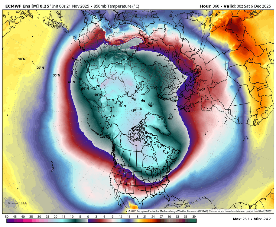
Snowcover and cold both become established in Canada by early December. This should help as the cold gradually pushes South with time.
-
.thumb.png.4150b06c63a21f61052e47a612bf1818.png)
November 2025 general discussions and probable topic derailings ...
HIPPYVALLEY replied to Typhoon Tip's topic in New England
Anything before mid December is going to require a bit of luck with regards to timing of cold air masses. I know sometimes you exaggerate, but I get it, it feels important to get an early season system to produce at least a few inches for SNE set a good winter vibe. -
2025-2026 ENSO
so_whats_happening replied to 40/70 Benchmark's topic in Weather Forecasting and Discussion
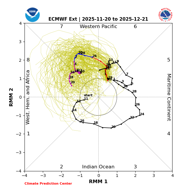
This is correct. So in QBO-E years it is fairly typical to see a disturbed SPV early on just as we are seeing in November and early December, namely a wave 1 response takes place. QBO-W years tend to have this take place around January leading to a stronger SPV (take last year as an example. The wave 1 response is due in part to a strong MJO passage through phase 3. Within about 2-3 weeks we typically see the passage through phase 7 (which is about where we are). The phase 7 is tricky though because it does not always push into a split scenario but I think we have a better chance with a much more pronounced stratospheric ridging staying in place and strength. I would like to see more negatively tilted troughs into the Atlantic to start to get more excited for that potential, these are the mechanisms to allow for poleward eddy flux versus a deflection as bluewave has noted. The Pacific has shown many negatively tilted troughs over the past few weeks hence the already well pronounced ridge. I hope we can get some type of Scandi ridging in the troposphere as we move into December. This is why I have been saying for awhile now I will wait to see that potential split scenario as we get close to the end of December but this remains to be seen. First let us actually have a push into phase 7 and see how the pattern lands. I will not be surprised to see with this displacement event a brief period of wintry weather in December (mid month area) to us quickly recovering and maybe having an early January 'thaw' type setup. -
14 day forecast verification for PNA is pretty bad, more positive of the 14 day forecast...take note moving forward
-
Domination in the SE by mild/SE ridge in the first half of Dec has been forecasted by the Euro Weeklies for over a week. They’ve been steady as a rock. I’d be very surprised if it isn’t mild in the means.
-
I'd take a continuous series of light to moderate events that don't erode a block, vs one "big dog" storm that melts off in 4 days. Snow-on-snow is the best!
-

November 2025 general discussions and probable topic derailings ...
dendrite replied to Typhoon Tip's topic in New England
I was just trying to give Scooter something with his gravy. -
 It’s great when it’s snowing . Really helps the holiday vibes heading into a snowy holiday night . Well that was when it used to snow
 -

November 2025 general discussions and probable topic derailings ...
Typhoon Tip replied to Typhoon Tip's topic in New England
You're a lost soul to the realm you were meant to roam. Utqiagvik calls to you. The sun just set at that location and won't rise again until January 22nd. -
PNA forecast staying closer to neutral now & not as deeply negative & trends positive in later: And, PNA for the most part keeps verifying above forecasts: FWIW
-
 Only if we go full December 2020. Non-stop shotgun blasts.
 -

November 2025 general discussions and probable topic derailings ...
WinterWolf replied to Typhoon Tip's topic in New England
I think what I said is very true… models catching on to SSW and the changes that may cause will take some more time. -
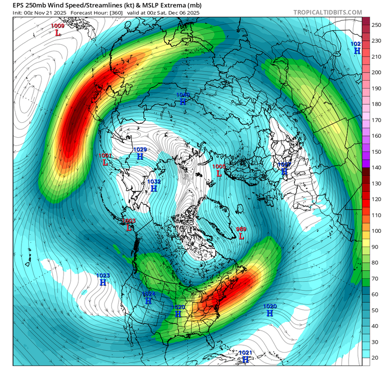
Winter rarely just blasts into the MA early season. It's a carving process and we're usually 3rd on the list when it happens (MW first, NE second, etc). First week of Dec looks like a carving process to me. This is an interesting jet panel. If you animate d10-15 it's pretty clear that the eps wants to press (or carve) the northern jet down into our latitudes. Still not good enough here but the process is ongoing Overall it's an encouraging jet structure with split flow and convergence. Mean QPF panels show moist SW flow embedded in this. If this verifies, areas to our west and NE will be in the crosshairs for overrunning type snowfall. If the carve continues southward it would be our first real window of opportunity beyond d15. Patterns like this can be active with precip but not really a big storm pattern. Which is probably good. It's really really hard early season to get a wound up storm to track underneath of us or be cold enough for snow. Much higher odds with a weaker shortwave zipping along
-

November 2025 general discussions and probable topic derailings ...
WX-PA replied to Typhoon Tip's topic in New England
Barrow for you my friend -

Central PA Fall Discussions and Obs
Itstrainingtime replied to ChescoWx's topic in Upstate New York/Pennsylvania
That's really cool. Nerd alert: just this week I was on WGAL's YouTube page waxing sentimental while watching Joe's (and @AllWeather) videos from before and during the great January 2016 snowstorm. I love going back and reliving moments like that. There are videos on the page from about 3 days prior to the storm all the way through the event finale. Best part is watching the forecasted amounts go up and up as the event approached and played out. I do this probably once every few months. Truly. -

November 2025 general discussions and probable topic derailings ...
CoastalWx replied to Typhoon Tip's topic in New England
Instead you have 6 months of sweat. Enjoy! -
Slightly more stronger going into 8 than yesterday
-

November 2025 general discussions and probable topic derailings ...
MJO812 replied to Typhoon Tip's topic in New England
I want 6 months of darkness -

2025-2026 ENSO
40/70 Benchmark replied to 40/70 Benchmark's topic in Weather Forecasting and Discussion
No...no, I wouldn't; I got 2.5" and then a flip to rain. It was actually a rather traumatic event. -

November 2025 general discussions and probable topic derailings ...
weatherwiz replied to Typhoon Tip's topic in New England
Yes, although now its a bit more difficult since last summer our dog had a severe spinal stroke which has left very little mobility/control of his back legs so his playing days are over. But the hope from the neurologist was over time he would get back to 100% but it never happened. We did a third and final MRI back at the end of the summer and it revealed the part of his spine that had the stroke (it was his second one) is slowly being replaced by fluid, so we went the wheel chair route and he loves it...can go on walks again! But being able to go on walks again is phenomenal. -
November 2025 general discussions and probable topic derailings ...
Typhoon Tip replied to Typhoon Tip's topic in New England
Definitely a colder complexion returned to the guidance overnight. There were some odd solutions there for a couple cycles when considering the principle component/indexes. Likely it was just typical pattern change guidance games all along. We see this going the other way in April where the indexes suggest the season's first big warm up ... but then the GFS wanders off in a spontaneous pita-flop day dream in the other direction. So in this situation .. I'm wondering if we might end up in a split flow type during those first couple of weeks of Dec. There's likely to verify that large scale -WPO/-EPO changing of the guard over the Pacific, but there's been some persistence in the various ensemble clusters to pin the geopotential anomalies along 120 W. Typically that results in flow bifurcation over the Pac NW, with the N resulting stream being a cold loader flow spanning across Canada, while the S branch meanders through the S Rockies... This can be good for overrunning storm types. If the blocking features lose latitude if/where they set up ...that may trigger more +PNA response underneath than we are presently seeing - whole different ball game. But the idea here is a seasonal dump ( we'll see if all this results in more as the times near) of polar-arctic cold at least down to 40 N across the Continent. As far as particularly dailies and what storms form, if/where those do or not... etc etc... too vague for the time being to make much of any play call. -

Texas 2025 Discussion/Observations
Powerball replied to Stx_Thunder's topic in Central/Western States
UPDATE: 3.95" is the official final total per FWD... -
Baja Low has screwed us over many times in recent Years. Hard to dislodge the Pattern when a standing powerful SER has developed in response. Maybe the MJO will dislodge it if it gets to cold Phases at enough Amp. A Block upstream would help particularly with a 50-50 in place. Without it you risk the SER, -NAO hookup.
-
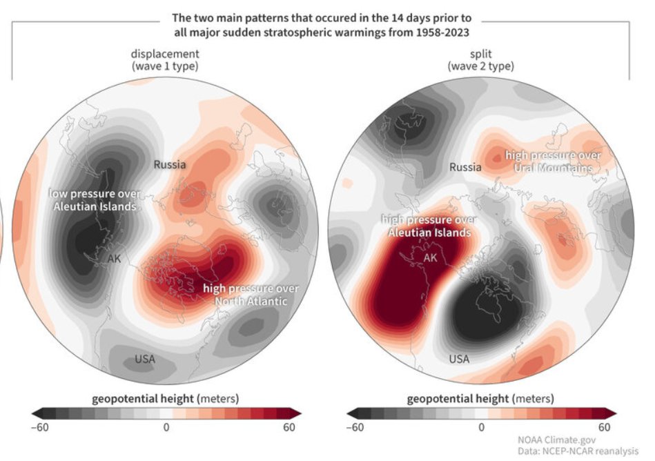
It's actually a little bit interesting, the way things are unfolding for the PV. Having previously seen the wave 1 tropospheric precursor pattern (displacement). In the weeks prior. Followed by the displacement event we've all been monitoring in the stratosphere now. Now, looking at some ensemble runs moving forward. We're resembling something pretty close to the wave 2 precursor (split). Which, if we take into consideration what looks to be a meaningful phase 7 mjo transit upcoming (known for PV disruption). Plus the associated WWB mentioned out at the dateline. That should act to give another boost to the AAM. If I'm recalling correctly, split events are typically achieved with a wave 1 attack (preconditioning) followed up by wave 2. Added all up raises an eyebrow a little bit. I'll just add, "setbacks" (or vice versa) from a European perspective doesn't necessarily equal the same to someone in the US for anyone reading.