All Activity
- Past hour
-

Richmond Metro/Hampton Roads Area Discussion
wasnow215 replied to RIC Airport's topic in Mid Atlantic
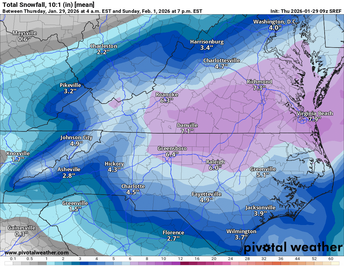
I would love it but has decent amount of snow into DC -
I fully expect the euro gfs cmc to kill this within the next 2 hours and then we can move on to the 6-14 threats
-

Possible coastal storm centered on Feb 1 2026.
ORH_wxman replied to Typhoon Tip's topic in New England
GFS Should be better than 06z but that isn't saying much. -

Richmond Metro/Hampton Roads Area Discussion
Ephesians2 replied to RIC Airport's topic in Mid Atlantic
At 36h the GFS is a tick west at 500mb. If the CAMs are right about this second Bermuda low it won't matter. But worth noting -
Yep, Godfather III lol
-

February 2026 Medium/ Long Range Discussion: Buckle Up!
Paleocene replied to Weather Will's topic in Mid Atlantic
normally i'd agree with you but this winter is built different. the atmosphere remembered how to be cold. as PSU always says, just gotta time the cold with a wave right... (not shown: matching CPC chart which shows below normal precip ) -
FOK down to -5 this morning. Man cold
-
A balmy 12.5 for the low.
-

The Jan 31 Potential: Stormtracker Failure or 'Tracker Trouncing
Kay replied to stormtracker's topic in Mid Atlantic
F it, I'll hang on to track a slight chance of a tiny pack refresher. I feel emotionally strong enough at this time. -

Possible coastal storm centered on Feb 1 2026.
dryslot replied to Typhoon Tip's topic in New England
I gave it until 0z friday, Its rapidly approaching. -

Possible coastal storm centered on Feb 1 2026.
Snowcrazed71 replied to Typhoon Tip's topic in New England
I was there yesterday, but, what's another 12z run to confirm things. -
Might not be that bad. No first call yet
-

1-30/2-1-26 Arctic Blast, ULL Snow Event
Hurricaneguy replied to John1122's topic in Tennessee Valley
Can someone post a zoom in of East TN for the NBM? Looking good on the wider map -

February 2026 Medium/ Long Range Discussion: Buckle Up!
Twilly05 replied to Weather Will's topic in Mid Atlantic
Hang in there! We’re gonna score! -
Who is breaking out the TROWEL?
-

The “I bring the mojo” Jan 30-Feb 1 potential winter storm
DTP replied to lilj4425's topic in Southeastern States
SC DNR has a really good write-up for a close analog to this type of setup that occurred on 1.2-1.3.2002 PDF file is too big to post, but worth the read if you do a quick Google search....it shows the entire upper air synoptic progression/summary in good detail throughout the storm -
 Because the thread goes through Virginia
 -

The “I bring the mojo” Jan 30-Feb 1 potential winter storm
wxdawg10 replied to lilj4425's topic in Southeastern States
Every pulling for trends that contradict one another for their backyard.. That's the nature of snow in the south -
I remember looking at the forecast the morning of and thinking gosh it sure is snowing a lot, it might be more than a couple inches lol.
-

Possible coastal storm centered on Feb 1 2026.
Wxbear25 replied to Typhoon Tip's topic in New England
I definitely wouldnt forecast a hit for anyone outside of Nantucket at this point, but my hope lies in the anomalous nature of this whole setup. Speaking of the setup/// That connection between that departing ULL over the NE and our chunk of energy diving into the upper midwest needs to separate faster. Each of their momentums are screwing us in different ways, so I agree wholeheartedly with @dendritein his post last page The momentum from the western side of things drives heights lower over the atlantic ironically, since thats barbelling southward dragging our eastern lobe with it. This ultimately make it harder for heights to recover from over the Atlantic which keeps the flow from backing and turning more meridional. The momentum from the eastern lobe pulls the western piece more eastward, giving us less wiggle room. The best way for that problem to solve itself is for our western energy to end up further west than modeled, similar to what happened a few days ahead of last weeks storm, and then pinch-off earlier which would theoretically alow it to dig more toward MS/AL instead of SC while simultaneously allowing heights to build off the coast -

Possible coastal storm centered on Feb 1 2026.
40/70 Benchmark replied to Typhoon Tip's topic in New England
Yea, if rest of 12z blows, I'm out. -
My car thermometer said 8 when I left for work this morning. Tonight might get down close to zero if we stay clear and calm wind.
-
Richmond Metro/Hampton Roads Area Discussion
wasnow215 replied to RIC Airport's topic in Mid Atlantic
So did DT come out with a first call map? because I just see his first guest map which seems ridiculous to me -

The “I bring the mojo” Jan 30-Feb 1 potential winter storm
Rsheely88 replied to lilj4425's topic in Southeastern States
Pretty big shift .