All Activity
- Past hour
-
91 DCA 93 BWI 94 IAD
-
Most of the area didn't
-

2025-2026 ENSO
Stormchaserchuck1 replied to 40/70 Benchmark's topic in Weather Forecasting and Discussion
Yeah.. the issue is that the long term WPO since the 1940s has gone linearly from negative to positive, coinciding with global warming. It might be an issue of not enough data.. Will be interesting to see if we can get a longer term -WPO time in this warmer climate phase. I really like the high correlation SSTAs from the Indian Ocean to Western Pacific summer-fall before a WPO event.. it appears to be somewhat predicable. The SSTs currently favor more of a +WPO Winter, I agree, but I think post-2023/4 something shifted and we don't have as much of a pattern as 2018-2023. -
We hit 90 briefly around noon and then overcast the rest of the day. Clearing now, but the sun is already letting go of its grip on the day. Tomorrow might be pretty joyless with the heat index.
-
2025-2026 ENSO
Stormchaserchuck1 replied to 40/70 Benchmark's topic in Weather Forecasting and Discussion
Yeah, I think a hotter than average July appears likely, even vs the last 10-20 years. -
18z gfs gone wild for July 4th-5th.
-
Perfectly and eloquently stated. Deep summer is locked in
-
 Historically in such a scenario the coast hits 100 early on (12-1) and then temperatures start to drop after 3 pm.
 -
Historically in such a scenario the coast hits 100 early on (12-1) and then temperatures start to drop after 3 pm.
-
did central park hit 90?
-
Cedar Rapids only made it to 93º both days this weekend, with a dew in the mid 70s, pretty standard for a moderate heat wave.
-
95 for the high currently 90/71
-
88 in Syosset & 87.8 in Muttontown for the high.
-
Clouds = heat fail today. humid but 80s and tolerable.
-
95 for a high
-
This is the earliest 80+ min on record for Chicago. Previous earliest was 6/28/1913 (min was 81 on that date).
-
temperatures now finally starting to drop at 7 pm. We hit 89 around 5 pm and hovered there for almost two hours lol
-
The heat wave is destined to break down .. obviously. That statement appears to be over selling tho. We’ll see but the thickness don’t fall below 570 behind a “weak boundary” - they’re right about that much… . Thats pretty warm and actually modestly above normal in that particular metric the whole time period averaged. There would likely be ocean modulation for eastern zones but BN may be a bit of an oversell inland in Thu/Fri. Winds also veer back s-SW by Sat and Sun. Aside from… nighttime lows will likely remain elevated if that geneal synoptic regime played out that way.
-
1233 tee time for me today. F that was hot.
-
Euro back to delivering quality weekends
-
That a warm , muggy 10 day. Not hot but where are the 50’s and chilly
-
Not bad! Once we get through the mild up looks like a week straight of nice sleeping weather.
-
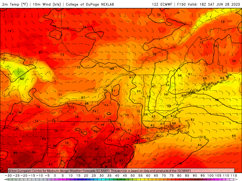
 Posted this on main June thread ... What I'm noticing about Monday and Tuesday is a very light wind field, almost NW to N as the surface flow begins to lose identity. Certainly a hot enough air mass to approach 100F in the NYC metro but will any weak sea breezes develop to keep readings in the low to mid 90s? I would bet on 102-105 in parts of NJ.
 -
I was outside way too much today. I soaked through two sets of clothes and pretty sure I lost 10lbs of water weight. Gross day but hey...productive.


.thumb.png.4150b06c63a21f61052e47a612bf1818.png)


