All Activity
- Past hour
-
Rain on the doorstep here….maybe Monday late morning it clears out….and we salvage…hope so.
-
probably both get together to make a decision
-
Who determines if a game is postponed ? The home team or MLB ? Perfect decision favoring the Yankees because Tampa Bay is in first and HOT and the Yanks are NOT !
-
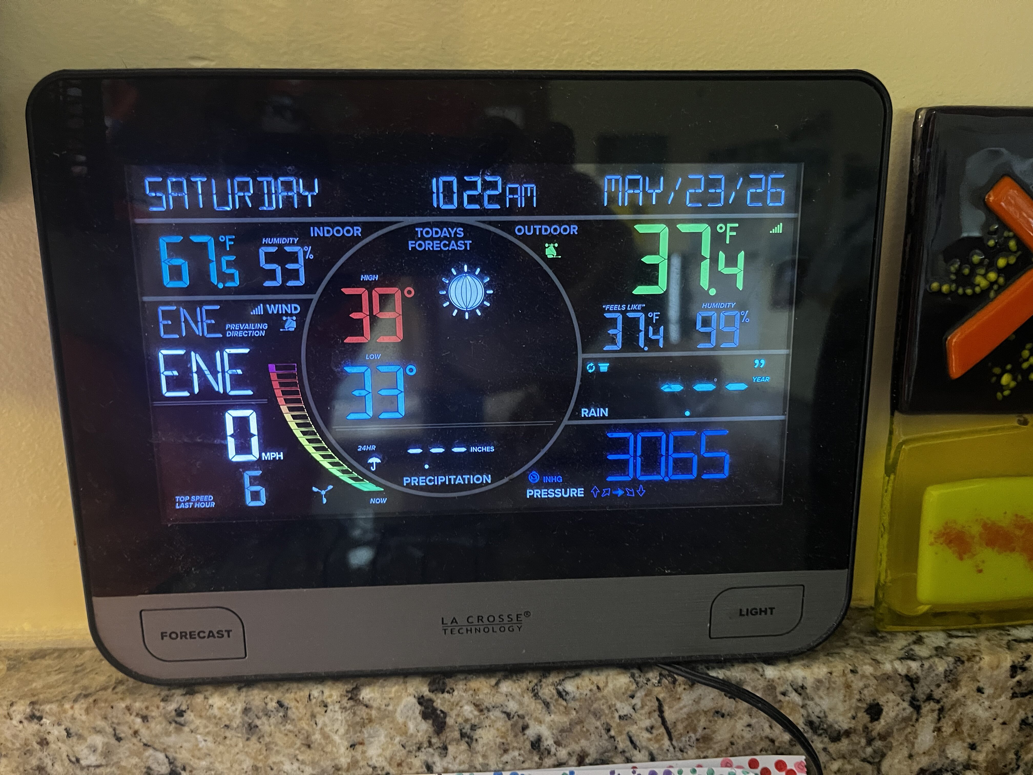
Low of 34F. Already 61F and nice out.
-
-

E PA/NJ/DE Spring 2026 Obs/Discussion
The Iceman replied to PhiEaglesfan712's topic in Philadelphia Region
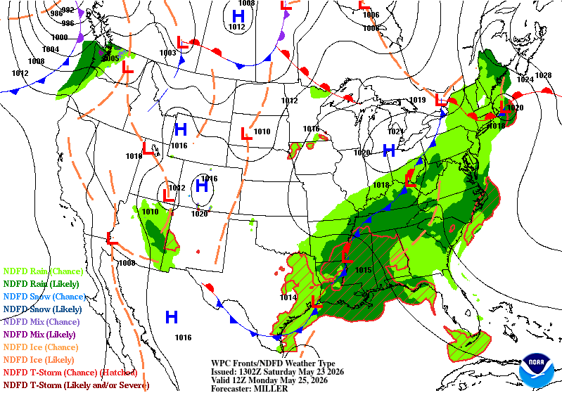
The heaviest precipitation was always expected for later this afternoon and overnight…still looking on track for most areas to get .5-1.5” today and tonight with more coming tomorrow night and Monday. -
Seems like a major forecast bust per my PWS, but too bad it’s not a little colder?

-
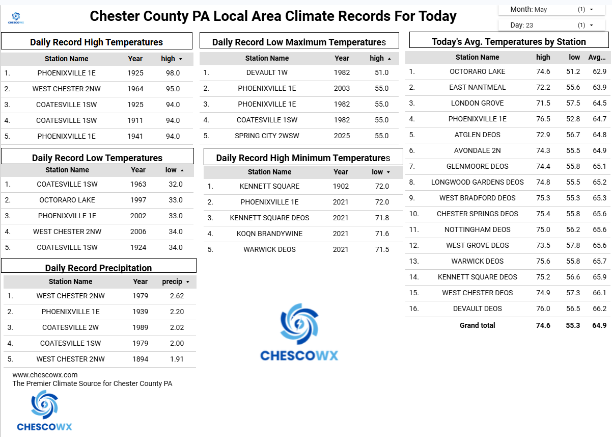
Records: Highs: EWR: 96 (1964) NYC: 94 (1964) LGA: 94 (1964) JFK: 92 (2021) Lows: EWR: 43 (1931) NYC: 43 (1963) LGA: 45 (1963) JFK: 33 (2022) Historical: 1783: Massachusetts lawyer James Otis often remarked to friends that when it was his time to die he hoped it would be by a bolt of lightning. Today he got his wish when he was leaning against a doorway in his home and lightning struck the chimney and traveled through the frame of the house, killing Mr. Otis. (Ref. Wilson Wx. History) 1814: Hailstones as large as 11 inches in diameter and weighing a half pound reportedly pounded parts of New Hampshire. (Ref. Wilson Wx. History) 1882 - An unusual late season snow blanketed eastern Iowa, with four to six inches reported around Washington. (David Ludlum) (The Weather Channel) 1925: Record maximum temperature for Washington DC. for the date is 97 °F. (Ref. Washington Weather Records - KDCA) 1953 - The temperature at Hollis OK soared from a morning low of 70 degrees to an afternoon high of 110 degrees to establish a state record for the month of May. (The Weather Channel) 1987 - It was a busy day for thunderstorms in the central U.S. Thunderstorms produced wind gusts to 65 mph at Shreveport LA and golf ball size hail at Marfa, TX. Hobart, OK, received 3.55 inches of rain in the morning, and another 4.03 inches of rain that evening. Thunderstorms in Nebraska produced 8.5 inches of rain in two hours north of Potter, and 7.5 inches of rain in ninety minutes north of Minatare. Thunderstorms in Colorado produced five inches of hail at Greeley. (The National Weather Summary) (Storm Data) 1988 - Thunderstorms produced severe weather across much of the eastern U.S. Golf ball size hail was reported in Georgia, Maryland, North Carolina, South Carolina and Ohio. (Storm Data) (The National Weather Summary) 1989 - Severe thunderstorms developing along a cold front resulted in 98 reports of large hail and damaging winds in the Northern Plains and Upper Mississippi Valley. Golf ball size hail caused a million dollars damage around Buffalo City, WI, baseball size hail was reported at Northfield and Randolph, MN, and thunderstorm winds gusted to 95 mph at Dunkerton, IA. (The National Weather Summary) (Storm Data) 1989 - Unseasonably hot weather continued in the south central U.S. Pueblo, CO, equalled their May record with a high of 98 degrees, and the high of 106 degrees at Midland, TX, marked a record six straight days of 100 degree heat. (The National Weather Summary) 1990 - A cold front crossing the western U.S. produced snow over parts of Oregon, California, Nevada, Idaho and Utah, with five inches reported at Austin NV, and four inches at Crater Lake National Park in Oregon. Strong winds behind the cold front sharply reduced visibilities in blowing dust over central California, and two multi-vehicle accidents resulted in one death and eighteen injuries. In northern Idaho, a cloud-burst washed tons of topsoil, and rocks as large as footballs, into the valley town of Culdesac. (The National Weather Summary) (Storm Data) 1991: Thunderstorms in the Denver, CO area produced large hail up to golf ball size. An estimated 5,000 homes and 8,000 cars received considerable damage. Damage was estimated at $60 million dollars. Hail accumulated to a depth of 6 inches at Aurora. (Ref. Wilson Wx. History) 1997: David McWilliams Ludlum was born 1910 in East Orange, NJ - He is responsible for researching and publishing Much of the early history of weather in early America. David died May 23, 1997 in Princeton, New Jersey. He was an American historian, meteorologist, entrepreneur and author. David M. Ludlum's death 2001: The temperature hit 116° at Palm Springs, CA. This tied their highest temperature for the month of May with 5/28/1983 & 5/28/2003. (Ref. Wilson Wx. History) 2002: A Pacific storm system brought some much needed snow to the Colorado Mountains and foothills with a mix of rain on the Plains. Snowfall totals included: 13 inches at Coal Creek Canyon, 11 inches near Evergreen, CO. The former Stapleton International Airport at Denver reported less than an inch. Three temperature records were set. The morning low temperature of 31° was a record low; as was the morning low of 32° the following morning. The high temperature of only 48° equaled the record low maximum.
-
Brutal.
-
Euro's been doing that all along
-
56 / 42 NE flow - cool , cloudy showers. What should tally up to 4 more days of mainly clouds with the brunt of the >1.00 - 2.00 inches of rain saturday night into Sunday night. Pokes of some sun Monday and Tuesday but slow to clear out. Much nicer Wed - Thu low 80s. Next cut off backs down and in between Fri and through next weekend and id wager it trends unsettled as ridge balloons into candada. Ridge finally expands east 6/3 - beyond pushing above normal overall.
-

Central PA Spring 2026 Discussion/Obs Thread
CarlislePaWx replied to Voyager's topic in Upstate New York/Pennsylvania
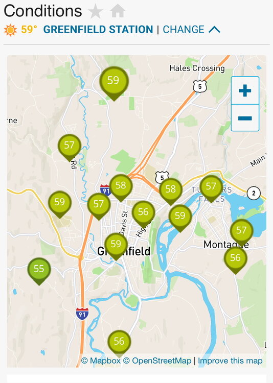
At 10:00am here in Carlisle, the temperature is 48.7 degrees. The low occurred 2 hours ago at 48.0. Light rain is falling at the moment. Since midnight I have recorded 0.90" of precipitation. Yesterday I recorded 0.25" for a 2-day total of 1.15". My high temperature (like most others) occurred at midnight and was 53.1 degrees. Of note, my high temperatures during the "heat wave" just a few days ago was 88.5 on the 17th, 96.4 on the 18th, 93.6 on the 19th, and I'll throw in 87.6 on the 20th. The heat (in my house) is back on again...lol. -
Trying to predict rainfall amounts in this set up is next to impossible IMO. Models don't have a handle on exactly where the heavier precip will occur. More than likely there will be a wide range of amounts spread throughout the region IMO.
-
It won’t bust the drought but this weekend and upcoming week is going to significantly bruise it. Up to 1.31” here myself and luckily it’s mostly fallen as steady soaking rain.
-
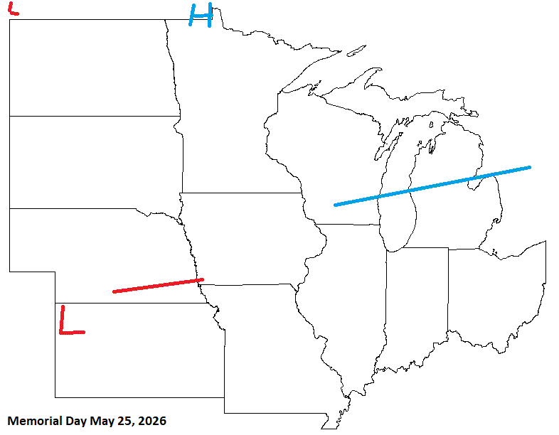
Deep summer weekend
-
Did ok with this forecast. A little off in the above map for Monday, but thought that might be the case as main front is through the sub by then. Conditions improve from W to E over the weekend. Enjoy your weekend EV1!
-
(002).thumb.png.6e3d9d46bca5fe41aab7a74871dd8af8.png)
Central PA Spring 2026 Discussion/Obs Thread
ChescoWx replied to Voyager's topic in Upstate New York/Pennsylvania
Temperatures across the area have dropped into the 40's after a midnight high in the low 50's. Today will be breezy and raw with rain increasing as we move through the afternoon and especially tonight. Most of the steadiest rain should exit Chester County to the east by later tomorrow morning. Most areas should see around an inch of rain by tomorrow afternoon. Some showers will continue on Monday begore we finally dry out on Tuesday. We briefly warm up to above normal temperatures by Wednesday before we trend back to below normal temperatures by the end of the week and into next weekend.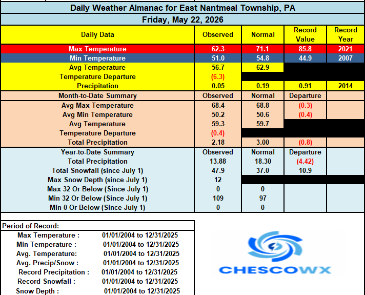
-
E PA/NJ/DE Spring 2026 Obs/Discussion
ChescoWx replied to PhiEaglesfan712's topic in Philadelphia Region
Temperatures across the area have dropped into the 40's after a midnight high in the low 50's. Today will be breezy and raw with rain increasing as we move through the afternoon and especially tonight. Most of the steadiest rain should exit Chester County to the east by later tomorrow morning. Most areas should see around an inch of rain by tomorrow afternoon. Some showers will continue on Monday begore we finally dry out on Tuesday. We briefly warm up to above normal temperatures by Wednesday before we trend back to below normal temperatures by the end of the week and into next weekend.
-
3k actually clears out most the area Monday afternoon. That would be a nice win for what will overall be a crappy weekend.
-
will need the heat here later and tonight for sure---52 and very light rain
-
Tops this list of 10 worst https://weather.com/storms/tornado/news/2019-04-12-ten-worst-tornadoes-in-us
-
Nothing like firing up the pellet stove on a Memorial day weekend. Sunday looks awesome..
-
Had to turn the heat on....51 outside. 66 inside.
-
Theme for pretty much the last two years... QPF overmodeled
- Today
-

E PA/NJ/DE Spring 2026 Obs/Discussion
Albedoman replied to PhiEaglesfan712's topic in Philadelphia Region
I was hping for some dowpours today. That is quickly dimisishing on this morning radar echo returns The hopes of getting out this drought are disapppearing. Everytime heavier bands form out in south western PA they race up to the center part of the state and cannot cross the Blue Mts. .25 daily inch rains are not good enough. It only allows the surface vegetation like grasses to say green longer. We should have a bumper crop yields for grains this year but at this time even the corn looks threaten and weak. This cold weather is unbearable. Coldest Memorial day I can ever remember. I have the space heater running in my office as solar raditonal heat cannot recover the temps in the house the next 3 days. Still wearing sweatshirts after this last heatwave. Wll , the landscaping mowing businesses will be loving this weather after the hoilday as they will be mowing everything that grew a foot high this weekend.


.thumb.jpeg.f5c6ba9d911ec96b3b124f8606aee58e.jpeg)
