All Activity
- Past hour
-
Bottomed out at 61.4 IMBY / east side Columbia.
-
Whoa 43 at Bittinger near Deep Creek. Crazy
-

2025 Atlantic Hurricane Season
NorthHillsWx replied to BarryStantonGBP's topic in Tropical Headquarters
Starting to see an uptick on models. Looks like two possible home grown systems then something from the MDR. August is here! -

Chester County PA - Analytical Battle of Actual vs. Altered Climate Data
chubbs replied to ChescoWx's topic in Climate Change
Yawn, all you are showing is that your station average doesn't match individual station data. Avondale and PHL are have similar trends for July Highs.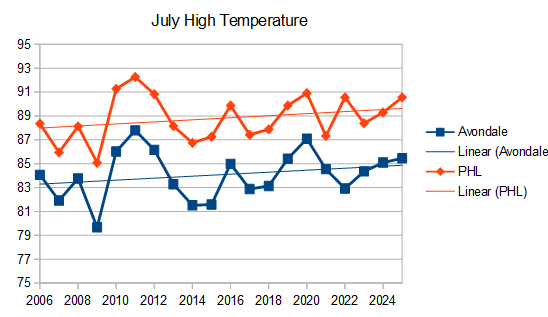
-
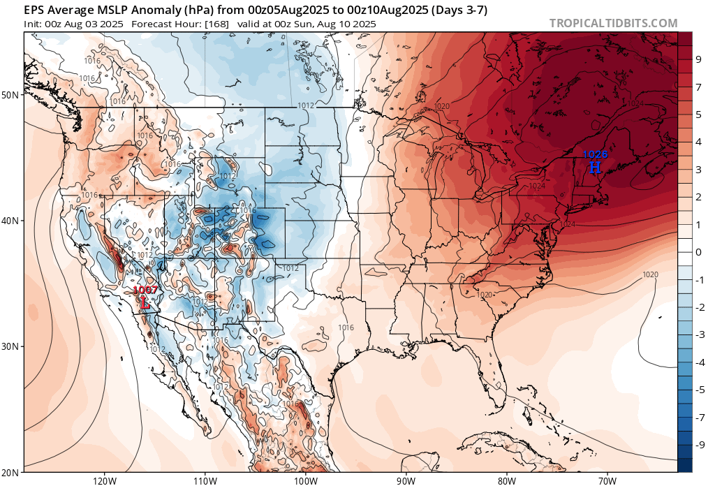
 LOTS of easterly flow in that EPS image... moisture.
 -
 The cool crisp air makes those fires smell even better when driving home. It was definitley hoodie weather!
 -
July 2025 Discussion-OBS - seasonable summer variability
wdrag replied to wdrag's topic in New York City Metro
Verification comments added to the initial post for July... actually imo, decently outlooked. -
 54 at the moment. Looks like one more night in the 50s tonight before the minimums creep up. Great bonfire last night, though some of our guests did have on sweatshirts which was comical in light of how hot it has been.
 -
If we do indeed flip to a -AAM regime along with -PDO and -ENSO/Nina, the CANSIPS for fall (SON) makes no sense
-
46.8F low here. Ouch
-
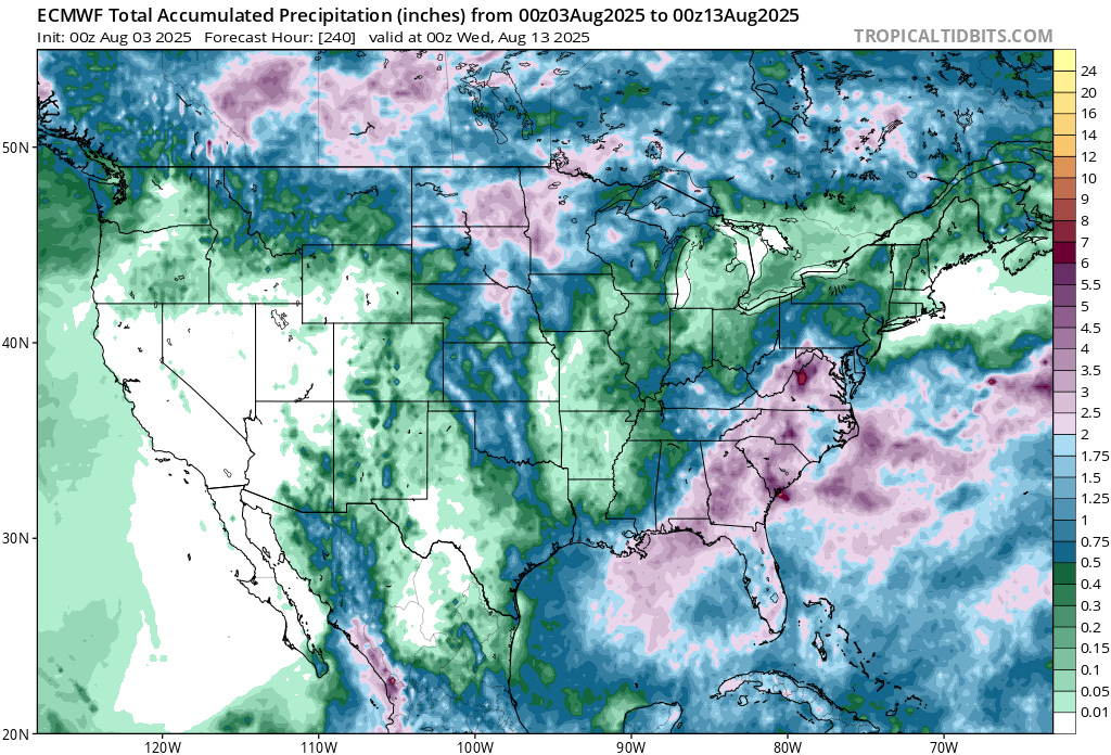
00z/3 GEFS and consequently WPC looks misleading dry and underplayed middle and end of this coming week... PA/NJ/NYS. Developing Ohio Valley upper low spells trouble this first week of August... before a major warming occurs 2nd and 3rd weeks of August-back to H&H then. So, I'll have to self criticize if the 00z/3 DRY WPC 7 day in PA/NNJ/NYS verifies-accountability for words Expressed. The rain may no exceed 1/4''' but I think something is coming to NJ/e PA/s NYS. Exactly how and when is my greater uncertainty. Difficult to get 7-8 consecutive days of no measurable. Can happen--- Adding verification to July in a couple minutes.
-
 This is going to be the best August weather we have seen in years. Very impressive Canadian high pressure will dominate. The easterly flow will keep the temperatures comfortable for this time of year with a break in the record heat that we experienced from late June through July. The high pressure will keep most of the rain to our south.

-
Back to Back 50F mornings, we take! Natural cooling while HVAC takes a break for a few days before going back on this week.
-

2025 Atlantic Hurricane Season
Silver Meteor replied to BarryStantonGBP's topic in Tropical Headquarters
Area Forecast Discussion National Weather Service Newport/Morehead City NC 426 AM EDT Sun Aug 3 2025 Mid to late-week, the upper level pattern will begin to change as troughing develops over the TN Valley, and as ridging sets up from the western Atlantic north through eastern Canada. During this time, medium range guidance is showing a pretty good signal for a blocky pattern to develop across the eastern U.S. and western Atlantic. Of note, medium range deterministic and ensemble guidance suggest the Atlantic may begin to "wake up" so to speak as we move into the latter half of the week. While the main development region (MDR) will be a potential candidate for tropical activity, it is also worth noting that guidance is beginning to show a signal closer to home for low pressure development along the frontal boundary off the Southeast U.S. coast later in the week. As we often remind folks this time of year, please be careful not to lock into one run of one model, as significant run-to-run changes can be expected. At this point, the main takeaway is to be aware of the potential. Stay tuned for updates from the National Hurricane Center through the week in case this risk were to increase. -
 Need a hoodie up here in the Berks this morning, temps are in the low 50's feeling fall like.
 -
1 mile from my house the epicenter was. Felt wayyyy stronger than the 2 we had last year. Legit shook me back into my couch. 55 degrees in Paramus, NJ right now. Someone in NW NJ has had to have gotten into the 40s.
- Today
-

E PA/NJ/DE Summer 2025 Obs/Discussion
BBasile replied to Hurricane Agnes's topic in Philadelphia Region
Hit a low of 56.6F this morning. The lowest temp since June 4 and the first temp below 60 since June 16. Currently 57.4F / 55F Dew -
58/56 Invigorating
-
48 degrees this morning, what nice weather!
-
Dang its 56 glorious degrees outside
-
54° / 50°
-
1. Western Atlantic (AL95): A non-tropical area of low pressure located along a frontal boundary about 180 miles off the coast of North Carolina is producing disorganized showers and thunderstorms. Environmental conditions are marginally favorable for this system to potentially become a tropical or subtropical depression or storm today or on Monday while it moves east-northeastward at about 10 mph, away from the coast of North Carolina. Environmental conditions become less conducive for development after Monday. For additional information, including gale warnings, please see High Seas Forecasts issued by the National Weather Service. * Formation chance through 48 hours...medium...40 percent. * Formation chance through 7 days...medium...40 percen
-
lmao Invest 95LAs of 06:00 UTC Aug 03, 2025: Location: 33.2°N 73.5°WMaximum Winds: 30 kt Gusts: N/AMinimum Central Pressure: 1010 mbEnvironmental Pressure: N/ARadius of Circulation: N/ARadius of Maximum wind: 50 nm
-
Invest 95L has been designated for the area off of NC, which may actually be just one of two potential systems to develop off of NC this week (the 2nd potential one is what the 18Z gfs went gaga with):Tropical Weather OutlookNWS National Hurricane Center Miami FL200 AM EDT Sun Aug 3 2025For the North Atlantic...Caribbean Sea and the Gulf of America:1. Western Atlantic (AL95):A non-tropical area of low pressure located along a frontal boundary about 180 miles off the coast of North Carolina is producing disorganized showers and thunderstorms. Environmental conditions are marginally favorable for this system to potentially become a tropical or subtropical depression or storm today or on Monday while it moves east-northeastward at about 10 mph, away from the coast of North Carolina. Environmental conditions become less conducive for development after Monday. For additional information, including gale warnings, please see High Seas Forecasts issued by the National Weather Service.* Formation chance through 48 hours...medium...40 percent.* Formation chance through 7 days...medium...40 percent.2. Central Tropical Atlantic:A tropical wave is forecast to move off the west coast of Africa in the next day or two. Environmental conditions could support some gradual development of the wave during the middle to latter part of next week while it moves generally west-northwestward across the central tropical Atlantic.* Formation chance through 48 hours...low...near 0 percent.* Formation chance through 7 days...low...20 percent. ——————— Meanwhile, the latest Euro Weeklies continue to suggest that quite an active August is favored.
-
yeah! https://www.si.com/betting/super-bowl-odds-public-betting-trends-every-nfl-team-01k1g90y4v4q Super Bowl Odds Baltimore Ravens +650 Buffalo Bills +700 Philadelphia Eagles +750 Kansas City Chiefs +800 Detroit Lions +1100 Los Angeles Rams +1700 Washington Commanders +1900 San Francisco 49ers +1900 Minnesota Vikings +2100 Green Bay Packers +2200 Cincinnati Bengals +2300 Houston Texans +2500 Los Angeles Chargers +2600 Denver Broncos +2900 Tampa Bay Buccaneers +2900 Arizona Cardinals +4300 Chicago Bears +4400 Pittsburgh Steelers +4400 Dallas Cowboys +4700 Seattle Seahawks +5500 Jacksonville Jaguars +6500 Atlanta Falcons +6500 Indianapolis Colts +7500 New England Patriots +8000 Miami Dolphins +10000 Carolina Panthers +10000 Las Vegas Raiders +11000 Tennessee Titans +17000 New York Jets +25000 New York Giants +27000 Cleveland Browns +33000 New Orleans Saints +40000