All Activity
- Past hour
-
 17/7/3
 -
Where did you think you moved to? Seriously though, I don't know if you actually understood the climate in New England. There have always been hot days, this isn't Labrador.
-
I haven't planted my cucumbers yet. Too cold. My tomato plants look the same as they did when I planted them 3 weeks ago. Just a little more unhealthy due to cold nights. Potatoes and cannabis don't seem to mind cold windy springs.
-
Smoke ‘em’ if you got em’?
-
We furnace we Stein this month
-
Low of 44 in Marysville on this 2nd day of June.
-
it's been interesting observing this unseasonable trough protect our region from smoke. The larger synoptic circulation associate with has kind of rampart the outside environment from getting into the interior trough axis. Folks may wanna keep in mind that today is the last day of said protecting... Not sure how/if smoke may factor into these "warm" days this week. MOS/machine guidance appears reasonable to me - normally I'd go a tick or two above during a recovery period in early Junes but trend to always be on the lowest side of correlations ( since last December really... ) always seems to find a way to perpetuate itself and this rendition it grabs a hold of smoke to perhaps keep us from making the illustrious 90 mark Wed/Thur haha. I mean like this spring's comically deducing means to prevent heat from materializing - despite the verified numbers ( relatively...)
-
40.2 for the low, currently 40.8/40.0 with clear skies.
-
Because weather forums are filled with psychos. happy birthday btw lol
-
Low of 48, nice walking weather.
-
My analysis isn’t contingent on whether folks here are receptive or not. My only focus is getting the pattern correct. You will notice how we haven’t had a single analog for any winter forecast issued in the last 30 years verify if that analog was in the prior base state. Base state number 1 was from the late 1800s into the late 1970s. Base state 2 was 1984 to 1997. Base state 3 occurred from 1998 to 2015. Base state 4 was from 2016 to 2022. The new warmest base state 5 only began in 2023. I have begun using this forecast and analysis technique with great success in recent years. But there are some overlapping features which have continued through the varying base states. Such as La Niña mismatch winters which I identified for the recent winter forecast last October. The mismatch replayed during the recent 24-25 winter leading to the strong -EPO and +PNA. But this base state was so much warmer that a 13-14 analog couldn’t be supported. This is what I pointed out last December. I first began using this technique back in the 2010s. There were numerous instances during this decade when some outlets were going with 1970s analog packages . But I pointed out how this new base state couldn’t support that type of cold. So in effect each new warmer base state had been producing weaker reflections from prior eras. Such as the 24-25 winter very weakly reflecting the strong +PNA -EPO of 13-14 and 14-15. But the much warmer Pacific and faster Pacific Jet eroded the ridge from the west leading to frequent jet extensions which knocked the ridge down. The other feature was the lack of a strong cold trough to the east. I also pointed out last fall how warm Canada was compared to those earlier years. Which continued into last winter. So the amount of Arctic air in North America was much more limited compared to 13-14 and 14-15. Since we are only a few years into this new warmer 2023 base state, there will probably be more weak reflections of winters from the past to come. But getting the levels of cold and snow and cold will struggle compared to earlier eras. The other thing to observe is that we still haven’t had a +7 winter and higher warm departure like occurred in 2001-2002 in this new much warmer climate from Philly to Boston. The departures in 23-24 and 24-25 have come in just below those levels with smaller departures than 01-02. So 22-23 was only about .5° cooler in the actual temperatures than 01-02 with a smaller departure in a much warmer base state. If we get a +7 in this new much warmer base state, then the 01-02 winter record for warmth will be easily eclipsed. But it’s uncertain as to whether or when we would see a +7 winter in this much warmer climate. Something that extreme would probably only become obvious once we’re were into the actual pattern. As it’s not easy to predict a +7 winter ahead of time. But my guess is that there is at least some chance we see a winter that would exceed the warmth experienced in 22-23 and 23-24 from Philly to Boston by 2030. The one caveat is a major volcanic eruption such as the earth hasn’t seen in hundreds or perhaps thousands of years to temporarily shift us back into a colder base state.
-
46° rain wtf is this
-
-
That’s a warm look on the EPS in the extended. NW flow aloft. Core of heat in Midwest and plains but pieces will try to break off. Maybe some storms too.
-

June 2025 discussion-obs: Summerlike
LongBeachSurfFreak replied to wdrag's topic in New York City Metro
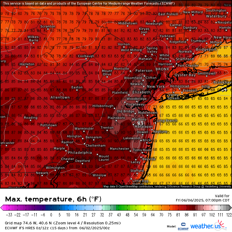
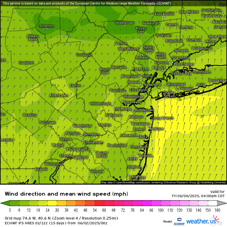
Abrose jet should really crank this week. Water temps are relatively low in the mid to upper 50s. Creating a stronger then usual temperature and pressure gradient from water to land. The ultimate seabreeze. People thinking this is the first beach weather week are going to be treated to a sand storm and a fridged afternoon wind. -
Started new summer thread...
-
Could be a wetter stretch in NNE Thursday-Saturday.
-
Will we have one? Discuss...
-
IAD got down to 44F and 43F yesterday and today respectively.
-
Not seeing a 1983 type pattern as we head into June. That summer featured a strong ridge over the Great Lakes with a trough near New England. So a strong westerly flow summer. The summer pattern coming up this week is the same one we have been experiencing the last decade. Elongated ridge to the north and east of New England and plenty of onshore flow. So NJ gets their first 90° of the season which is delayed while JFK and the South Shore gets a very strong Ambrose Jet.


-
Low of 46
- Today
-
My cucumbers and tomatoes have barely grown at all in the past month. Looks like lows in then 60s the rest of the week though.
-
0.08 last night 8P-midnight in Wantage NJ. No clear cut aurora at 3A today on camera.
-
Another example, they've had Thursday as mostly sunny in their forecast.. still do.. No mention of PM storms.. Weird
-
40 this morning.