All Activity
- Past hour
-

December 2025 regional war/obs/disco thread
HoarfrostHubb replied to Torch Tiger's topic in New England
I appreciate the effort you have put in. -
I feel a little better overall today vs a few days ago seeing that -NAO. It started to look a little dire with an overall +AO.
-
Oddly with enough warmth tomorrow - we could see or approach record highs (EWR-60 / NYC - 58)
-
What’s weird is the SE ridge is kind of displaced westward right now on weeklies…a little different than a few days ago…and the heights even further SE like near Bahamas/off SE coast are actually BN. Kind of weird…almost El Niño-ish.
-

December 2025 regional war/obs/disco thread
40/70 Benchmark replied to Torch Tiger's topic in New England
I got 1/4" from some squalls in between. -
Thats nice work @The 4 Seasons
-

December 2025 regional war/obs/disco thread
The 4 Seasons replied to Torch Tiger's topic in New England
The 9" is Barre Falls Dam COOP which is in the northeast corner of Barre. 12" is westminster from Cocorahs. and 7.1" is also cocorahs, Gardner 1.4 SSW. I'd include more reports from people here but unfortunately we no longer have the New England Snow page from Kevin so there's very few from here unless i know before hand what they are. -

Central PA Winter 25/26 Discussion and Obs
Itstrainingtime replied to MAG5035's topic in Upstate New York/Pennsylvania
That'll be a fun rush hour event. -

December 2025 regional war/obs/disco thread
Damage In Tolland replied to Torch Tiger's topic in New England
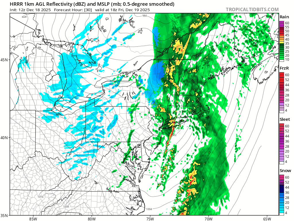
Hopefully something like the HRRR verifies https://x.com/dhtheweathernut/status/2001627717314449651?s=46&t=dhcbvkjmRcyBVQtDxJ3lRg -
Near perfect placement on that high. Look at that CAD signature.
-
Looks like NYC was at 0 departure on Wed and the below streak stopped at 20, EWR and other sites were still below yesterday. Today that will bring the below daily departure streak to an end at 20-21 days.
-
December 2025 regional war/obs/disco thread
HoarfrostHubb replied to Torch Tiger's topic in New England
You have 9" in or near Hubbardston MA which is close to what I have measured (10). (2 x 0.5", 1 x 2", 1 x 7"). Not sure if those are from my numbers. Someone in Gardner (Subdude?) is at 12" -
This is the Round 2 for midday / early afternoon tomorrow that I referenced in the above post. Interesting to see some impressive modeled reflectivities with that.

- 1,373 replies
-
- 2
-

-
- severe
- thunderstorms
- (and 2 more)
-
Will brings up a good point. With the models trying to torch January with a SE ridge, we’ll need that to persist. That stupid conus ridge isn’t lasting forever.
-
Temps and dews rose to 40 overnight and the melt is kicking into overdrive. A couple patches of grass showing in my yard
-

December 2025 regional war/obs/disco thread
weatherwiz replied to Torch Tiger's topic in New England
The real problem I think would be if the strong blocking persists. We would probably get chances as the block is materializing and then we'd want to hope for the block to relax or break down a bit and that could come with some chances. But if a big block materializes and becomes established...then we may be screwed -
Meanwhile euro had a nice SWFE. I’d hit it.
-

Central PA Winter 25/26 Discussion and Obs
AccuChris replied to MAG5035's topic in Upstate New York/Pennsylvania
HRRR showing a nasty “squall line” tomorrow morning . -
Big blocking would help out going into January imho. Most guidance keeps wanting -PNA and a SE ridge. If you overlay strong blocking, then it reduces the chances of cutters and torches. Lot of uncertainty though with the blocking. But it’s def been increasing on all guidance.
-

Central PA Winter 25/26 Discussion and Obs
pasnownut replied to MAG5035's topic in Upstate New York/Pennsylvania
for the record keepers. 19-22 was the "runnin" average on way to Etown. which was at 25 -
(002).thumb.png.6e3d9d46bca5fe41aab7a74871dd8af8.png)
Central PA Winter 25/26 Discussion and Obs
ChescoWx replied to MAG5035's topic in Upstate New York/Pennsylvania
Today will be our mildest day since the day before Thanksgiving with highs in the mid to upper 40's. Rain heavy at times arrives after midnight and continues into tomorrow morning. Combined with the melting snow and ice we could see some local flooding. Temperatures will rise into the low 50's toward morning before a strong cold front passes through with maybe a thunderstorm and then temperatures crash tomorrow during the day reaching near freezing by 5pm. There is a wind advisory in effect tonight into tomorrow so watch for some power outtages in the usual spots across the county. We then look to see temperatures bouncing below normal on Saturday, Monday and near normal Sunday, Tuesday and Christmas Eve. Our next chance of some snow or rain looks possible by Tuesday.
-
E PA/NJ/DE Winter 2025-26 Obs/Discussion
ChescoWx replied to LVblizzard's topic in Philadelphia Region
Today will be our mildest day since the day before Thanksgiving with highs in the mid to upper 40's. Rain heavy at times arrives after midnight and continues into tomorrow morning. Combined with the melting snow and ice we could see some local flooding. Temperatures will rise into the low 50's toward morning before a strong cold front passes through with maybe a thunderstorm and then temperatures crash tomorrow during the day reaching near freezing by 5pm. There is a wind advisory in effect tonight into tomorrow so watch for some power outtages in the usual spots across the county. We then look to see temperatures bouncing below normal on Saturday, Monday and near normal Sunday, Tuesday and Christmas Eve. Our next chance of some snow or rain looks possible by Tuesday.
-
Central PA Winter 25/26 Discussion and Obs
pasnownut replied to MAG5035's topic in Upstate New York/Pennsylvania
absolutely. This has been a very nice December, no matter how it ends, and it doesnt look torchy terrible. Yeah we'll have to suffer a bit, but thats normal and part of the gig. Have a good day all. -
Yep, best way to extinguish a torch is throw some H2O on it.
-
Central PA Winter 25/26 Discussion and Obs
Itstrainingtime replied to MAG5035's topic in Upstate New York/Pennsylvania
Low this morning of 22 which was far lower than I expected after the events of last evening. I had some sort of inversion that sent my temp from 30.2 at 8pm up to 36.8 at 9pm. Temp plateaued there and was still at 35.1 at midnight. Was able to shave off 13 degrees during the early morning hours.