All Activity
- Past hour
-

September 2025 OBS-Discussion centered NYC subforum
MANDA replied to wdrag's topic in New York City Metro
WPC usually on the conservative side so if you are looking / hoping for meaningful rain you gotta like the look of this. As Walt said still a ways off and details not solid but nice starting point.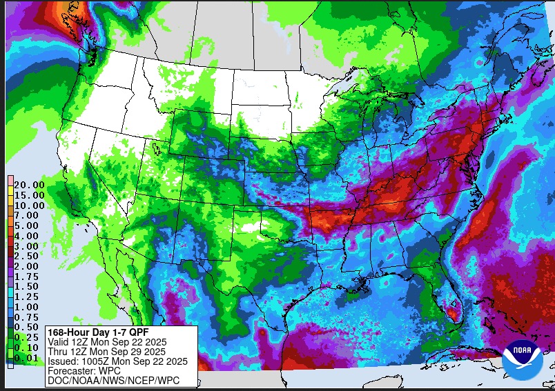
-
Rest of the month looks A and with regards to temperatures. I’m guessing the major stations will finish the month close to normal.
-

September 2025 OBS-Discussion centered NYC subforum
bluewave replied to wdrag's topic in New York City Metro
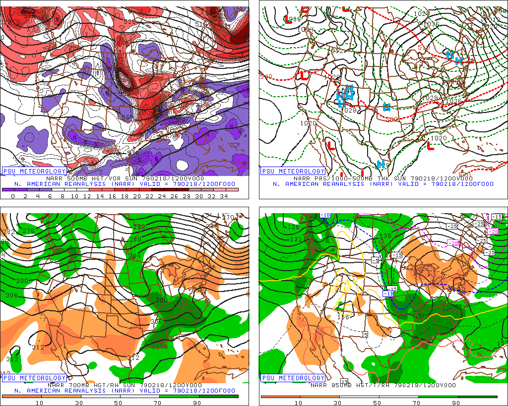
Especially in places like the Adirondacks. I remember wondering as a kid how Old Forge made it down to -52° in February 1979. The Arctic high settled right over that region for perfect radiational cooling. Data for February 18, 1979 through February 18, 1979 Click column heading to sort ascending, click again to sort descending. OLD FORGE COOP -52 STILLWATER RESERVOIR COOP -44 WANAKENA RNGR SCHOOL COOP -41 HINCKLEY 2 SW COOP -40
-
Need Sept 28th - 30th dry. Otherwise it can rain all it wants.
-
That would be a normal winter anymore.
-
WB 6Z AI in fantasy range....
-
For you northerners, but us southerners in GA, still seeing low to mid 80's after the next few days of low 90's
-
Sunday River tested their guns the other day. Some cold mornings starting next week might get a few others into test mode. We just need some rain for the ponds.
-

September 2025 OBS-Discussion centered NYC subforum
LibertyBell replied to wdrag's topic in New York City Metro
I think it also has to do with how quickly the cold gets scoured out after the sun comes up. And sometimes we get this kind of cold just before a storm comes in during the winter and a place like FOK goes from the lowest temperatures in the area to being the first ones to change from snow to rain lol. -
September 2025 OBS-Discussion centered NYC subforum
LibertyBell replied to wdrag's topic in New York City Metro
The patterns are astonishingly similar, dryness on both the east and west coast and wetness in between. winter 1984-1985 was cold and dry too (until February when we warmed up very quickly after a frigid January with one of our strongest arctic shots in my lifetime.) -
The AOI nearest to the Lesser Antilles may need its own thread due to a potential threat at least to the Bahamas late this week and possibly even the US E coast/Canada. This was a TC on the admittedly untrustworthy GFS as far back as the 0Z 9/18 run and consistently on runs the last couple of days, including some ensembles. Also, the Icon and Euro have at least hints that this may turn into something: East of the Leeward Islands: A tropical wave located about 400 miles east of the Leeward Islands continues to produce disorganized showers and thunderstorms. Environmental conditions appear marginally conducive for slow development over the next few days as the wave moves quickly westward to west-northwestward at 15 to 20 mph. By the latter part of this week, the system is expected to slow down and turn more northwestward, and a tropical depression could form late this week when the system is over the southwestern Atlantic Ocean or near the Bahamas. Regardless of development, gusty winds and showers are expected to affect portions of the Leeward Islands late tonight and Tuesday. * Formation chance through 48 hours...low...10 percent. * Formation chance through 7 days...medium...40 percent
-
September 2025 OBS-Discussion centered NYC subforum
LibertyBell replied to wdrag's topic in New York City Metro
Wow Don, I see there's a lot of years between 1984-1985 and 2024-2025 even though the rainfall amounts were only off by about 2.5 inches. Was September 1984-August 1985 the driest such period during the 1980s decade? -

September 2025 OBS-Discussion centered NYC subforum
FPizz replied to wdrag's topic in New York City Metro
Fake cold like other places are fake warm (anthony) 47 here this morning -
September 2025 OBS-Discussion centered NYC subforum
LibertyBell replied to wdrag's topic in New York City Metro
Frost in the Poconos (MPO) Don? -
September 2025 OBS-Discussion centered NYC subforum
LibertyBell replied to wdrag's topic in New York City Metro
Who had our coldest temperature this morning -- was it FOK or MJX? It's usually one of the two. MVY in SE NE is also very cold on such mornings. -

September 2025 OBS-Discussion centered NYC subforum
wdrag replied to wdrag's topic in New York City Metro
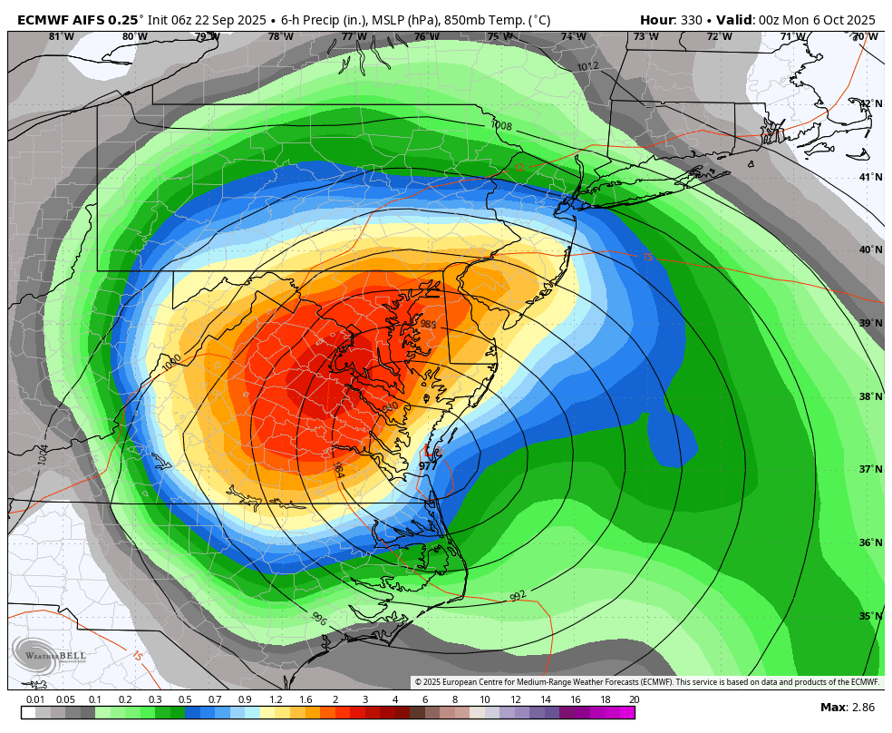
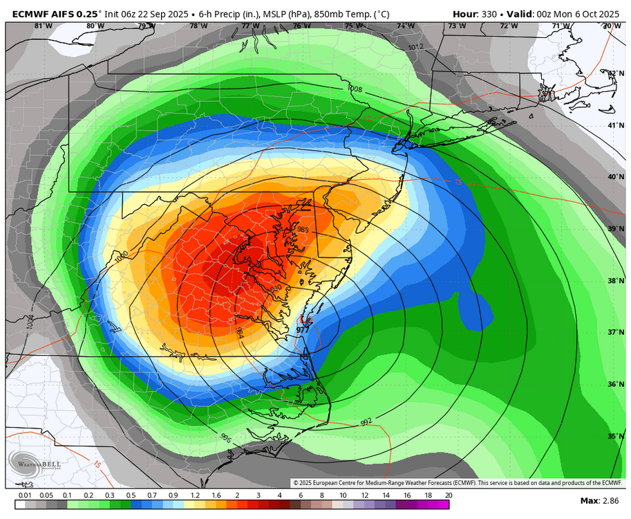
No thread attm--maybe something delayed now til late Tuesday???: need more ensemble support but still looking at widespread 1-3 rainfall totals Tuesday afternoon-next Sunday with iso 5+ POSSIBLE. Depends on evolution and track of developing UA low Ohio Valley middle and end of next week... ie stall the showery late Tuesday surface CFP just to our south Wed-Sunday with weak waves of low pressure. LONG Ways off but am not too alarmed by the recent dryness... happens and then a blast of rain. We do need that OH Valley Upper Level (5H for example) LOW to form and eject across NJ next Sunday as it finally weakens. Otherwise wait til October. All ensembles 1+. My greatest doubt is Fri-Sun...whether the tilt to the trough is more positive than what I thought yesterday, not permitting the Fri-Sun portion of the qpf into our area but shunting it further south across the Delmarva?? Yes, am aware that this OH Valley trough and eventual eastward progress might build the w ATLC ridge enough to permit a tropical threat late Sun-next Tuesday=this paragraph said with little confidence but awareness. For now... lets get some beneficial rain in here Tue-Thu. I haven't checked on the svr threat. Have a day. -
Occasional Thoughts on Climate Change
LibertyBell replied to donsutherland1's topic in Climate Change
This is very disappointing, downsloping flow is how we get our hottest summers (like 2010) but now it gives us tainted yellow skies and air pollution. -

September 2025 OBS-Discussion centered NYC subforum
STORMANLI replied to wdrag's topic in New York City Metro
44° -
I dunno. I’m not feeling a storm named “Humberto” is going to break our cane futility streak. Not ominous sounding enough
-
BULLETIN Hurricane Gabrielle Special Advisory Number 22 NWS National Hurricane Center Miami FL AL072025 900 AM AST Mon Sep 22 2025 ...GABRIELLE RAPIDLY INTENSIFIES INTO A MAJOR HURRICANE SOUTHEAST OF BERMUDA... SUMMARY OF 900 AM AST...1300 UTC...INFORMATION ---------------------------------------------- LOCATION...30.6N 62.2W ABOUT 195 MI...310 KM SE OF BERMUDA MAXIMUM SUSTAINED WINDS...120 MPH...195 KM/H PRESENT MOVEMENT...N OR 10 DEGREES AT 10 MPH...17 KM/H MINIMUM CENTRAL PRESSURE...957 MB...28.26 INCHES Hurricane Gabrielle Special Discussion Number 22 NWS National Hurricane Center Miami FL AL072025 900 AM AST Mon Sep 22 2025 Satellite images indicate that Gabrielle has rapidly intensified into a major hurricane with a well-defined eye. The current intensity is set to 105 kt, a blend of constrained Dvorak estimates of about 100 kt with higher Data-T values of 115 kt. Further intensification is expected today, and the intensity forecast is raised for the first 24 hours, then kept the same afterwards. Small changes were made to the wind radii to account for the stronger hurricane. No changes were required to the track forecast. FORECAST POSITIONS AND MAX WINDS INIT 22/1300Z 30.6N 62.2W 105 KT 120 MPH 12H 22/1800Z 31.3N 62.1W 115 KT 130 MPH 24H 23/0600Z 32.9N 60.5W 110 KT 125 MPH 36H 23/1800Z 34.4N 57.4W 95 KT 110 MPH 48H 24/0600Z 35.4N 53.1W 90 KT 105 MPH 60H 24/1800Z 36.0N 47.6W 80 KT 90 MPH 72H 25/0600Z 36.7N 41.5W 75 KT 85 MPH 96H 26/0600Z 40.7N 28.9W 70 KT 80 MPH 120H 27/0600Z 44.2N 19.9W 55 KT 65 MPH...POST-TROP/EXTRATROP $$ Forecaster Blake
-

September 2025 OBS-Discussion centered NYC subforum
IrishRob17 replied to wdrag's topic in New York City Metro
It is an interesting microclimate phenomenon for those that appreciate weather as a whole. The fake cold thing is a term made up by those who must rely on Canada for their cold and can't generate their own. Only got down to 46 this morning, the dews are up a bit and clouds moved in. -
Looks like a low level wedge of fog south and east of I-95.
-

September 2025 OBS-Discussion centered NYC subforum
lee59 replied to wdrag's topic in New York City Metro
50 degrees here this morning -
I see a slight south trend with 6z..though best is still north of me. Pike to SNH?
-
Dick Tolleris?

.thumb.png.4150b06c63a21f61052e47a612bf1818.png)