All Activity
- Past hour
-

December 2025 regional war/obs/disco thread
WinterWolf replied to Torch Tiger's topic in New England
That thing sucks…lol. But ok. -
That was the max on 12/25/2020 at CAR. +35 anyone?
-
18z Nam's a wreck. I think we're better off if the 12/5 threat fizzled and left some energy behind for our next long shot.
-
1.4" snow/sleet .. total event QPF 1.07"
-
im crying old bay tears, where's our side of the Potomac? Nice map tho
-
And what about all the southern sliders fails with HPs being too strong? How much of that is bad luck/timing with an active NS?
-
They get worse every year.
-
Where's JI? I came for some doom scrolling. I saw PSU commented so I got excited. Nothing juicy yet. Still early season lol
-
I was using the CFS
-
18z NBM is north relative to a lot of what we’re looking at it seems
-
December 2025 regional war/obs/disco thread
WinterWolf replied to Torch Tiger's topic in New England
I was thinking the same thing…how did he see that? Or did he mean last year/or previous years? -
How would to EPS and Euro show New Years Day temps? they don't go out far enough
-
We’ve been in a Nina ish pacific base state for a long time. That isn’t good for gulf miller a type systems.
-
That’s exactly what the GEFS is showing; an Aleutian ridge regime (-WPO) as opposed to an Alaskan ridge regime (-EPO)…..
-
euro SE at 12z
-
How we doing? Euro ok? Been busy drinking beer on the job. Because it’s my job! I know everyone throwing me a pity party for my oh so rough life.
-
Well we rarely get Miller As anymore. We don’t have many clipper underneath of us. The waa overrunning of a Miller B is less impactful Those are the three changes I note from 20+ years ago and the question is Why!?.
-
December 2025 regional war/obs/disco thread
WinterWolf replied to Torch Tiger's topic in New England
Kind of the tenor(if I do say so) of the early season so far….to mute the big long range looking torches as they move closer to go time. Not a bad tenor to have if you like wintry weather. -
Nice snow base with daily mood flakes? We are so back.
-
saw some 50s on NYD. Lots of time, but we all know what happens between xmas and NYE
-
Slanted at that angle is it going to go ese because it’s pointing ene
-
Verbatim, it’s showing an Aleutian ridge regime (-WPO), if it goes poleward, as is being shown, it would tap cross-polar flow/arctic air into western Canada
-

2025-2026 Fall/Winter Mountain Thread
Maggie Valley Steve replied to Buckethead's topic in Southeastern States
Looking like a Winter Weather Advisory will be hoisted tomorrow for Thursday night into Friday morning across the Mountains. GSP in their Hazardous Weather Outlook is mentioning snow tomorrow night mixing with sleet/freezing rain/rain Friday morning as the warm nose builds in during the daylight hours of Friday. -
5:1 ratios for this would be my guess as well
-
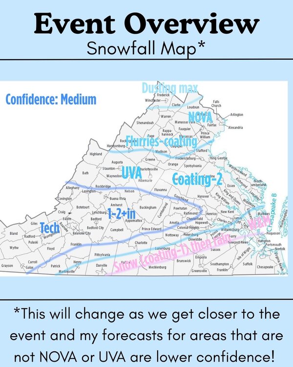
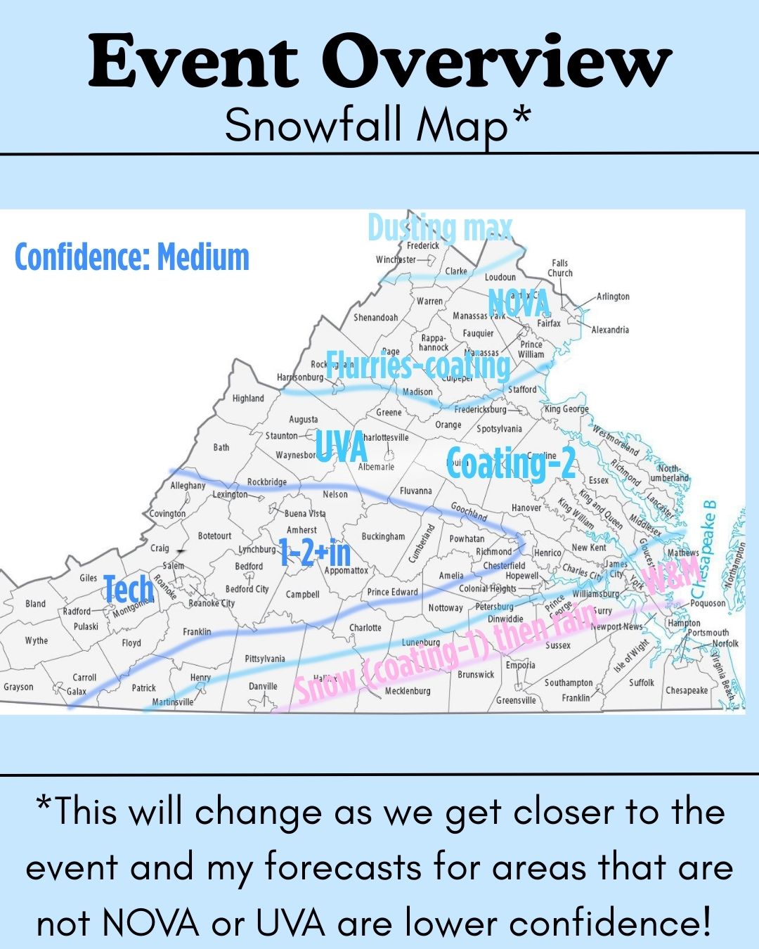
First stab at a snowfall map (made for my instagram but might as well post it here). Since it's made for public consumption I always hedge my bets a bit so its a bit more conservative than my true thinking.