All Activity
- Past hour
-

Spooky Season (October Disco Thread)
tamarack replied to Prismshine Productions's topic in New England
Only 5 years away here, as we hit 11° on 10/32/2020. Pawpaw question: Are they more cold-hardy than the Reliance peach? We planted a Reliance the first spring here, 1998, and for 2 years it would grow quickly then die back in winter. The winter of 2001-02 never got below -12 and the following summer we had 100+ sweet tennis-ball-size peaches. Jan-Mar 2003 featured 12 minima of -20 to -29 and the tree was dead. (It tried a small sprout from below the graft, but that died before first frost.) We're at 4B here - median for winter's bottom is -24, though that measure is climbing. -

Spooky Season (October Disco Thread)
Torch Tiger replied to Prismshine Productions's topic in New England
looks light inland, 20-30 mph-type fare. more like a whisper. Hope for flooding -
I can't access radar so I can't see, but it seems to me that the earlier moat that existed has been filled and we don't have any indication of an ERC? If that is the case, and we do not have an ERC on the table, tonight may actually be the time when Melissa peaks given the diurnal cycle and its impact on the periods of intensification/convective activity we've seen...This structure is as high end as you can get in the basin. It's also worth noting that this is the only part of the basin where something like this is possible. This last image really crystalizes it. As anomalous as it gets for this time of year.
-

Spooky Season (October Disco Thread)
OrangeCTWX replied to Prismshine Productions's topic in New England
Looks like Friday night/Saturday on the backside of the system is where we would see any winds as the surface low deepens up in Canada. -
They do follow the solar cycle, but with an anti-correlation. Extreme tropical cyclones are least likely to occur during the solar maximum. However there's a very strong positive correlation with AGW.
-

2025 Lawns & Gardens Thread. Making Lawns Great Again
dendrite replied to Damage In Tolland's topic in New England
I assume you’ve tried them. Any particular variety? The wild seedling ones can have some weird flavors or unpleasant aftertaste. But seedlings with two high quality parents generally produce very good fruit as well. -
30-40 inches that common in jamaica?
-
Spooky Season (October Disco Thread)
dendrite replied to Prismshine Productions's topic in New England
I moved the plant posts to the garden thread. -
2025 Lawns & Gardens Thread. Making Lawns Great Again
dendrite replied to Damage In Tolland's topic in New England
In ground. They handled the Feb 2023 -18° with -45° wind chills fine. Grafted trees take about 5 years. Seedlings 7-8. It depends on genetics too. I pull the seeds and then scoop it. When they’re really ripe they have a custard like texture. You should hit up the guy in Marlborough next fall. His entire 1/4 acre is pawpaws and persimmon. FYI…I’ll move all of the plant posts to the garden thread. -
Lots of parallels to Helene in western NC from a flooding standpoint. Somewhat similar topograph/rainfall amounts/duration. Jamaica can probably handle it a little better with heavy rainfall from tropical systems being much more common in that part of the world
-
"Decades" is a bit hyperbolic - longest recorded stretch (in the modern-day satellite era at least) with no Cat 5 is 9 years; but yeah they're definitely increasing in frequency. They generally seem to follow the solar cycles actually, and since we're at the peak of one...
-
Jamaica's coastline is relatively steep in most places, so the surge is less likely to be a concern. Rainfall and wind are the big-ticket items here. This is probably more akin to Maria in PR as anything else.
-
AGW
-
Just built first fire of the season. A cloudy and cool day with light E/NE breezes making it feel a bit cooler than the current 51.0/41.2 at 2 pm.
-
.thumb.png.4150b06c63a21f61052e47a612bf1818.png)
2025 Lawns & Gardens Thread. Making Lawns Great Again
HIPPYVALLEY replied to Damage In Tolland's topic in New England
Scoop. It’s very much like a little custard cup. -

Central PA Fall Discussions and Obs
Superstorm replied to ChescoWx's topic in Upstate New York/Pennsylvania
2:00 PM EDT Mon Oct 27 Location: 16.5°N 78.3°W Moving: WNW at 3 mph Min pressure: 906 mb Max sustained: 175 mph . -

2025 Atlantic Hurricane Season
Brian5671 replied to BarryStantonGBP's topic in Tropical Headquarters
A day ago looked like western Jamaica would be spared the worst winds now it looks to go right over them -
I remember we went decades without a category 5. Now it's a regular occurrence. Incredible.
-
What will help some is that the mountains have trees, which will help prevent mudslides. If it was a place like Haiti where the mountains have been denuded of trees, there would be massive mudslides, with little or no warning, causing more deaths, and devastation.
-
It's basically a cutter now-a slug of heavy rain then dryslot
-
In a mountainous island like Jamaica it absolutely is true. Obviously winds will be devastating at the center, but the biggest impact for the island will be the sheer amount of rainfall from this event that will be exacerbated by topo with mass amounts of fresh water having nowhere to drain during the height of the storm due to surge.
-
The visible high res .5k satellite photo shows an insane eye, with the mini vortexes, etc. blob:https://www.tropicaltidbits.com/23d25d52-a94f-4476-b368-fed4d4c0dc75 The eastern 2/3rds of Jamaica are going to get raked for a prolonged period of time due to it being on the western semi-circle of the hurricane.
-

2025-2026 ENSO
brooklynwx99 replied to 40/70 Benchmark's topic in Weather Forecasting and Discussion
this is a pretty wild change near Japan since August. that heatwave is almost entirely wiped out... wondering if this is a change to a +PDO down the road, especially if we get a Nino next year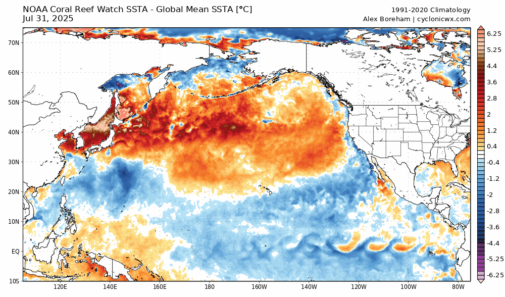
-

2025 Lawns & Gardens Thread. Making Lawns Great Again
DavisStraight replied to Damage In Tolland's topic in New England
Do you scoop the meat out and eat it or more like an apple?


