All Activity
- Past hour
-
Nice catch. Weird how the nowdata apparently reports it from the previous day.
-

2025 ENSO/Winter Speculation
Prismshine Productions replied to 40/70 Benchmark's topic in New England
Little warner and less snowy than last year Sent from my SM-S166V using Tapatalk -
We should fall around 73.4 (based on some rough estimates), which would put us just outside the top 5. What is really impressive is the next lowest of this century is 2013 at 24.7, which ranks 22nd. We did it mostly through high temperatures remaining lower, with no particularly anomalous lows. That's the way to do August!
-
Gotta subtract out that 7/31 data. Belchertown had 1.91” and Amherst 1.42”.
-
I’m not saying the QBO is unfavorable at all. As to solar, yes, I’d agree that solar is similar. Both sunspot and solar flux numbers are back up over 200. And it looks like we are about to have a big uptick in geomag activity
-
What a boring decade.
-

2025 Lawns & Gardens Thread. Making Lawns Great Again
wxeyeNH replied to Damage In Tolland's topic in New England
Brian, do you remember? We got these Chestnut tree saplings when they were like 10" tall. How many years ago was that? I have several growing, but I should have planted them closer for pollination when they get bigger.
-
china ftw
-

2025-2026 ENSO
brooklynwx99 replied to 40/70 Benchmark's topic in Weather Forecasting and Discussion
although I didn't like the results, I would run the 500mb pattern back in a heartbeat. that winter was a clinic on how to get the least amount of snow with favorable 500mb patterns
-
2025-2026 ENSO
brooklynwx99 replied to 40/70 Benchmark's topic in Weather Forecasting and Discussion
looking at RONI, the MJJ this year is -0.4 and last year it was -0.45. i also don't take the N ATL SSTs into account all that much, I find correlations with our weather pretty weak. even though the heatwave near Japan is stronger, the SSTs off the WC are also higher, so the PDO is about the same. if anything, it was more consistently under -3 last year overall, I think there are a lot of big picture similarities. I don't like to get too granular with LR forecasting -
Followup on AEW coming off Africa as early as tomorrow: 12Z UKMET: has a TS that is already recurving before 40W: NEW TROPICAL CYCLONE FORECAST TO DEVELOP AFTER 138 HOURS FORECAST POSITION AT T+138 : 15.3N 32.1W LEAD CENTRAL MAXIMUM WIND VERIFYING TIME TIME POSITION PRESSURE (MB) SPEED (KNOTS) -------------- ---- -------- ------------- ------------- 1200UTC 03.09.2025 144 16.0N 33.0W 1010 37 0000UTC 04.09.2025 156 16.9N 35.4W 1010 40 1200UTC 04.09.2025 168 18.6N 37.0W 1010 38
-

2025-2026 ENSO
40/70 Benchmark replied to 40/70 Benchmark's topic in Weather Forecasting and Discussion
QBO is not unfavorable this year and La Niña is still going to be weak. This seems like splitting hairs to me...and believe me, I want a repeat of last winter like a hole in the head. -
 Station locations may have played some role in influencing the numbers. But the 1980s and 1990s were still unique.
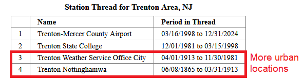
-

2025 Atlantic Hurricane Season
LongBeachSurfFreak replied to BarryStantonGBP's topic in Tropical Headquarters
Up here on Long Island Erin took the water temps from the high 70s to the high 60s temps recovered to the low 70s which is about normal for this time of year. Hurricanes in the north east derive their energy from the Gulf Stream and will weaken once above the north wall. It’s a function of the long shallow continental shelf. - Today
-
Mother Nature does it for him.
-
He stirs
-
Radar based QPE sucks out here. BTown coop is 84% of normal mtd and very near the 25% of normal contour on this map. Pretty big diff. Amherst coop is 75% of normal mtd.
-
I’m not disagreeing with the 500mb +AO/+NAO, however, there are many big differences I see, namely last year’s Nina didn’t get going this early, it was a late-bloomer event, we didn’t have a strong -IOD and the AAM was the complete opposite. We had the very strong Nino like +AAM right into November, this year, deep -AAM. The PMM is and has been very negative this year, was not negative at this time last year. The North Atlantic didn’t have the south of Greenland to Davis Straight cold pool last year. Also, the marine heatwave around Japan in the NW PAC was getting bombarded with recurving tropical cyclones and extratropical storms coming off the coast, which was upwelling and cooling the SSTS in that area, not the case this year, in fact SSTS are 11 degrees F above normal in that area currently. Further, the QBO has flipped
-
 All my highs for the week got bumped to near 80. What the heck
 -
Occasional Thoughts on Climate Change
donsutherland1 replied to donsutherland1's topic in Climate Change
New AMOC update: https://iopscience.iop.org/article/10.1088/1748-9326/adfa3b The latest update using the most up-to-date climate models does not present good news. The study used advanced climate models to look beyond the 21st century. Under high-pollution scenarios, the models showed the AMOC weakening throughout the 21st century before eventually shutting down in the 22nd century. Even under more moderate scenarios, the circulation sometimes collapsed, suggesting the risk is greater than scientists previously believed. The paper's chart depicting the scenarios is below: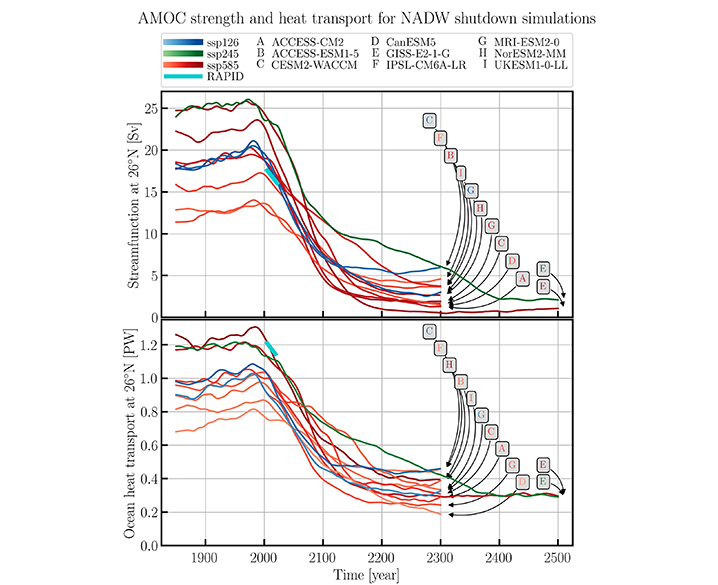
-
CWG has officially declared death!
-
2025-2026 ENSO
brooklynwx99 replied to 40/70 Benchmark's topic in Weather Forecasting and Discussion
looking at the 500mb patterns over the last two summers, last year is a good match... had the same +NAO/+AO as well as the dual ridges over the western and eastern US. last year is also a good PDO, solar, and overall ENSO match as well. I think it holds a good bit of weight
-
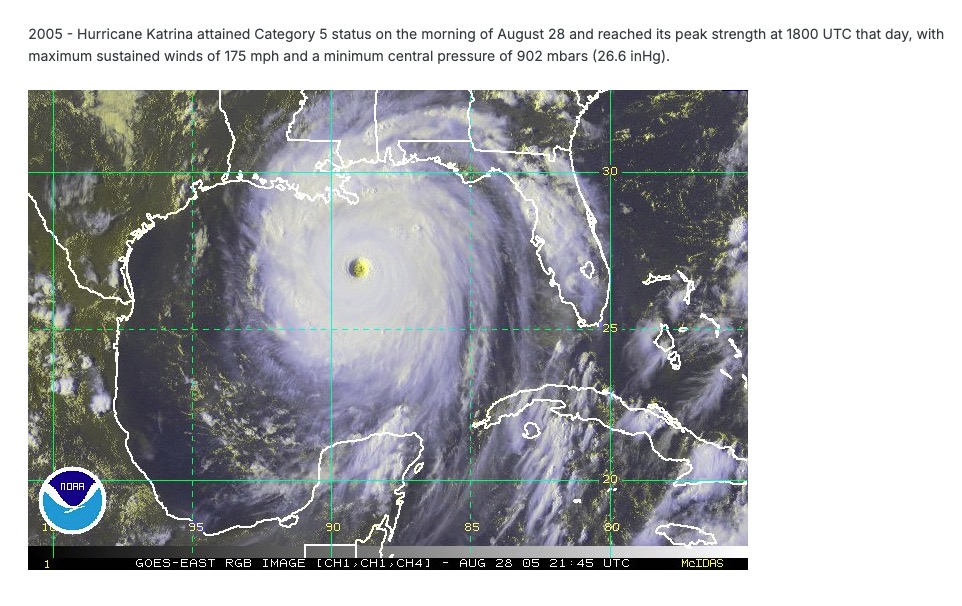
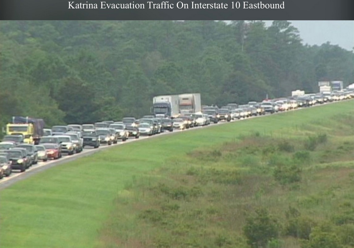
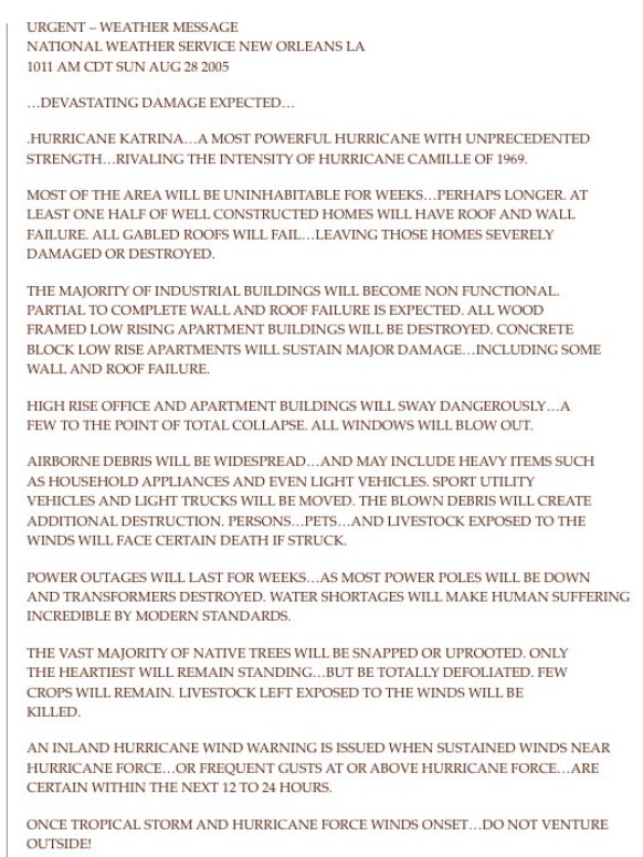
 Records: Highs: EWR: 102 (1948) NYC: 100 (1948) LGA: 99 (1948) JFK: 98 (1973) Lows: EWR: 51 (1941) NYC: 50 (1885) LGA: 54 (1986) JFK: 53 (1986) Historical: 1816: Frosts continue in New England i 1898 - Torrents of rain accompanied by a furious wind upset the rain gage at Fort Mohave AZ. However, water in a wash tub set out on the mesa, clear of everything, measured eight inches after the 45 minute storm. (The Weather Channel) 1911 - Saint George, GA, was deluged with 18.00 inches of rain in 24 hours to establish a state record. (The Weather Channel) 1954: Thunderstorm winds and hail struck Alachua and Orange Counties in Florida. A tornado touched down briefly in Orlando and ripped up three large oaks. Considerable wind damage to roofs and several automobiles were hit by falling trees. A child was killed by lightning at Lake City, FL. Several others were injured. (Ref. Wilson Wx. History) 1959 - Lieutenant Colonel William Rankin bailed out of his plane at a height of 46,000 feet into a violent thunderstorm, and lived to write about the 45 minute journey (which normally would have been a thirteen minute descent). He described it as one of the most bizarre and painful experiences imaginable. (The Weather Channel) 1964: NASA launched the first NIMBUS weather satellite. More advanced than the pioneering TIROS satellites, the NIMBUS program featured new cameras and sensors that continued well into the 1970s. (Ref. Wilson Wx. History) 1968: One man was seriously injured by lightning while riding on a roller coaster at a Denver, CO amusement park. An airline employee was injured when lightning struck a jetliner he was servicing at Stapleton International Airport. A lightning caused fire did extensive damage to a house and to several others. (Ref. Wilson Wx. History) 1971 - Heavy rains from Tropical Storm Doria caused devastating floods in central and northeast New Jersey resulting in 138 million dollars damage. In southeastern Pennsylvania, high winds downed trees and power lines, and in New York City, heavy rains flooded streets and subways. (David Ludlum) 1973 - An F4 tornado touched down near Canaan, New York, and moved to western Massachusetts. Three people were killed in West Stockbridge, Massachusetts when a truck stop was destroyed, and another person died in a ruined house nearby. 1974: Central New Jersey--Lightning resulted in one death. Sanford, NC -- A woman in her backyard was hit by lightning and died in a hospital. (Ref. Lightning-The Underrated Killer.pdf) 1977: Severe flooding hit parts of southwest Oklahoma after 8 to 10 inches of rain fell over the area. The hardest hit areas were between the West Cache and Blue Beaver Creeks, near the communities of Cache, Faxon, and Medicine Park, all in Comanche County. Six children had to be rescued by helicopter from a knoll between the two creeks, while several other families had to be evacuated. Damage was quite severe as many houses reportedly had two to four feet of water flowing through them. The floods also washed away several bridges. (Ref. Wilson Wx. History) 1978: Hail up to six inches deep was recorded during a severe thunderstorm at Colorado Springs, CO. (Ref. AccWeather Weather History) 1980: Two inches of snow fell at Sherman Pass, WA. (Ref. AccWeather Weather History) 1982: A strong cold front pushed through bringing record low temperatures across parts of the Great Lakes and Ohio Valley. Record lows included: International Falls, MN: 30°, Duluth, MN: 34°, Marquette, MI: 36°, Lansing, MI: 36°, Ste. St. Marie, MI: 37°-Tied.(Ref. Additional Temperatures Listed On This Link) 1985: In the early morning hours eight inches of rain pounded Le Mars, IA. Every home in town had some problems and houses that had never had water in their basements suddenly had 6 inches of water standing on their floors. Later that afternoon, more severe weather developed in northwest Iowa pounding several counties with golfball size hail and high winds in excess of 60 mph. Window and tree damage was extensive across Emmett, O'Brien, Cherokee, Clay, Buena Vista and Plymouth Counties. (Ref. Wilson Wx. History) 1986 - The temperature at Apalachicola, FL, dipped to 62 degrees to shatter their previous August record by four degrees, having tied their August record high of 99 degrees on the 2nd of the month. (The Weather Channel) 1987 - Severe thunderstorms broke the heat in the southeastern U.S. and the Gulf Coast Region, but not before seven cities reported record high temperatures for the date. The severe thunderstorms produced wind gusts to 80 mph downing large trees around Horse Shoe NC, and pelted southeastern Meridian MS with hail two inches in diameter. (The National Weather Summary) (Storm Data) 1988 - Tropical Storm Chris spawned a tornado near Manning, SC, which killed one person, and spawned three tornadoes in North Carolina. Chris produced one to two foot tides, and three to six inch rains, over coastal South Carolina. Severe thunderstorms in New York State and Vermont, developing ahead of a cold front, spawned a tornado which killed one person at Hector NY, produced tennis ball size hail at Brandon VT, and produced wind gusts to 80 mph at Lyndonville VT. (The National Weather Summary) (Storm Data) 1989 - Early morning thunderstorms in Nebraska produced 4.50 inches of rain around McCook, and 4.65 inches near Auburn and Brownville. Showers in Montana pushed the rainfall total for the month at Havre past the previous August record of 3.90 inches. (The National Weather Summary) 1990 - Between 3:15 p.m. and 3:45 p.m. a devastating F5 tornado ripped a 16.4 mile-long path through portions of Kendall and Will counties in northern Illinois. A total of 29 people were killed, and 350 more were injured. An estimated $160 million in damages occurred. The tornado's path width ranged from 200 yards to half a mile. A total of 470 homes were destroyed, and another 1000 homes were damaged. Sixty-five thousand customers lost power. 1992: The coolest August temperature ever recorded in Wichita Falls, TX when the temperature fell to a cool 53°. Rapidly intensifying Typhoon Omar cut right across the U.S. territory of Guam in the western Pacific. At the time of landfall winds were sustained at 125 mph around the eye. Anderson Air Force Base had sustained winds of 104 mph with a peak gust to 150 mph, recorded a pressure reading of 945.8 millibars or 27.93 inches of mercury, and was deluged with 16.41 inches of rain. Agana Naval Air Station reported wind gusts exceeding 170 mph and a low pressure reading of 932 millibars or 27.52 inches of mercury. One person was killed, 132 people were injured, over 4,000 homes were damaged or destroyed, and total damage was $487 million dollars. This was the strongest typhoon to strike Guam since Typhoon Pamela in 1976. (Ref. Wilson Wx. History) 2001: Snow plows in the summer! Hail mostly three quarter inches in diameter but a few stones as large as 1 1/4 inches in diameter fell on the west side of Silver City, New Mexico for 40 minutes and accumulated to a depth of 6 inches. Many vehicles were stranded until snow plows could clear hail from the roadways. (Weather Guide Calendar with Phenomenal Weather Events 2007 Accord Publishing, USA) 2002: A very far to the north occurrence for this phenomenon. A funnel cloud was seen and photographed from near Wonder Lake in, AK’s Denali National Park. The funnel appeared several miles north of the lake; the bottom of the visible funnel almost touched the ground. (Weather Guide Calendar with Phenomenal Weather Events 2011 Accord Pub. 2010, USA) 2003: Two men were struck and injured by a nearby lightning strike at the Albemarle County, VA Fair in the North Garden area of the county. (Ref. Lightning - Virginia Weather History) 2005 - Hurricane Katrina attained Category 5 status on the morning of August 28 and reached its peak strength at 1800 UTC that day, with maximum sustained winds of 175 mph and a minimum central pressure of 902 mbars (26.6 inHg). 2011: Many homes in Chesterfield, VA area were hit by trees and power outages over the Richmond and Glen Allen area is still about 70 percent. (Ref. Richmond Times Despatch) (NWS, Sterling Reporter Volume 10, Issue 4 Page5) (NWS, Sterling Reporter Volume 10, Issue 4 Page6) 2012: Sixth of the top ten weather events - Hurricane Isaac. August 28-29th Category 1 Isaac made landfall in Southeast Louisiana and moved slowly northward across the state bringing heavy rain and flooding to Louisiana and Mississippi. Five died, some 900,000 customers lost power in Louisiana, and losses totaled $2.35 billion. Top 2012 Weather Events (Ref.Weatherwise May/June 2013 volumn 66 /number3 page 17) 2017: Harvey was a Category 4 hurricane at its peak. It has since been downgraded to a tropical storm. But the hurricane scale is based on wind speed, not volume of water, and Harvey has continued to funnel tremendous amounts of moisture into Texas. The flood of epic proportions is not finished with Houston and large parts of southeast Texas. After 30 to 45 inches of rain, quite possibly the greatest rain storm in U.S. history, another 10 inches could still fall. Meanwhile, excessive rains have pushed into New Orleans, which was under a flash flood warning Tuesday morning. In the 24 hours ending Tuesday morning, 4-12 inches of new rain had fallen across in Houston, adding more water to a landmass that is fully saturated. “This is as catastrophic as you could possibly imagine from a Category 4 storm.” (The NWS said Monday the 28th that parts of Harris County had seen 30 inches of rain.) (15 inches of rain and more to come)Computer Models Indicate Harvey Will Stall Over Texas (SE,TX After 30 to 45 inches of rain and more to come) 2020: Thursday PM (2020 - August 27) At that time, Laura's outer bands had begun moving onshore along the Louisiana coast, accompanied by strong winds, steady rain and several possible tornadoes. Hurricane Laura made landfall along the Louisiana Gulf Coast near Cameron, LA just after midnight on Thursday morning (27 August) as a high-end category 4 hurricane with maximum sustained winds of 150 mph. The minimum central pressure at landfall was 938 millibars (27.70 inches of mercury). At the time of landfall, a National Ocean Service tide station at Calcasieu Pass, LA observed a water level rise of 9.19 ft Mean Higher High Water due to the storm surge. Simultaneously, the strong winds pushed so much water toward the coast that the Neches River even flowed backward for a time, according to a U.S. Geological Survey (USGS) streamgage in Beaumont, TX USGS News. Following landfall, Laura continued traveling northward across Louisiana as a hurricane before weakening to a tropical storm when winds fell below 75 mph by noon on Thursday when the center of the system was approximately 50 miles to the east-southeast of Shreveport, in northwest Louisiana. By late Thursday evening, Tropical Storm had traveled to the north and north-northeast across Arkansas before weakening to a tropical depression approximately 30 miles to the north-northeast of Little Rock, AR. On Friday the 28th, Tropical Depression Laura continued curving toward the northeast as it traveled across northeastern Arkansas and then across southeastern Missouri and into western Kentucky. Just before dawn on Saturday morning, Laura became a post-tropical cyclone or remnant low as it was located approximately 90 miles to the west of Charleston, WV. Winds surrounding this remnant low were 25 mph. In terms of wind speed, Laura tied the 1856 Last Island hurricane as the strongest landfalling hurricane on record in the state of Louisiana since 1851; however, the 1856 Last Island hurricane had a lowest minimum pressure of approximately 934 mb (27.58 in Hg). Significant storm surge was generated by the winds accompanying Hurricane Laura, which resulted in coastal flooding. Widespread torrential rains with amounts ranging from six to ten inches fell across western Louisiana and eastern Texas. With widespread damage caused by strong winds, a significant storm surge and rains, over half a million people were without power.