All Activity
- Past hour
-
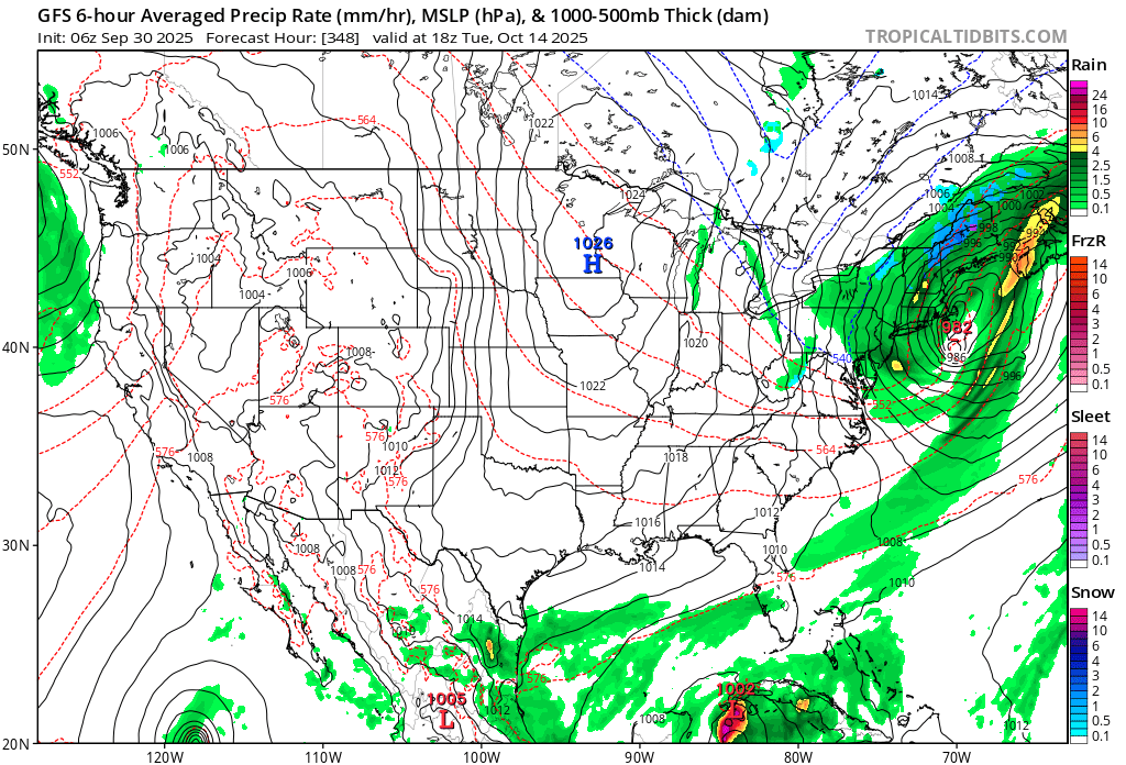
With the storm now moving in a more favorable direction considering the shear vector we are starting to see signs of strengthening this morning. Convection is firing over the center and starting to wrap into the dry slot the storm ingested last night. Despite the dry air, pressure falls have continued and we are now seeing convection become more organized as well. This system is well on its way to hurricane intensity
-

2025 Atlantic Hurricane Season
NorthHillsWx replied to BarryStantonGBP's topic in Tropical Headquarters
2025 ACE is now within about 10 of average. With the two ongoing storms, albeit with Humberto likely to become non tropical today, we will be within single digits of average. I cannot stress enough how impressive this is given how far behind we were just a couple weeks ago -
I couldn't agree more. He has the same exact words that he uses. He hypes things up so much that I just shake my head. It's nuts how much he believes what he's saying, and what's worse, he has a lot of followers and subscribers I totally believe what's coming out of his mouth. Pure bull crap.
-
Was a great site but I get it. Thanks for all your work.
-
Thanks, Kevin.
-
60 kts at 5 am but dry air has really slowed intensification. Models are pretty aggressive over the next 48 hours and some peak this near major. It likely won’t be a “pretty” storm but Bermuda looks to be in the bullseye of a strong hurricane. I really wouldn’t be shocked if this makes a run at cat 3 near the island. A lot of upper level dynamics at play including a very strong sting jet progged across guidance as the storm approaches the island. Very interested to watch the evolution
-

2025-2026 ENSO
40/70 Benchmark replied to 40/70 Benchmark's topic in Weather Forecasting and Discussion
We are "due" for a lot of things right now, but +EPO wouldn't be the most prominent item on my list. I mean...we have had 2 -WPO seasons over the past decade.....I haven't had one normal or above snowfall season in a decade. I won't include temps because we all know why that is. We have had 7 La Nina seasons out of 10 years, and 1 El Nino...and the El Nino season was still largely negated by the prominent cool ENSO hemispheric base state. -
2025-2026 ENSO
40/70 Benchmark replied to 40/70 Benchmark's topic in Weather Forecasting and Discussion
2019-2020 was pretty damn positive. -
I like a relatively warm October. 70s, sunny, and cool nights.
-
Im in jamaica till friday. If i come back to the same humidity up there as down here and missed a few cool nights im gonna be pissed lol
-
Because danger to and destruction of others’ property and lives gives you a thrill. Got it, and “whining like a child” when it stays ots. Sheesh. Barry GBP would be proud of you. Right, Barry? Barry?
-

Spooky Season (October Disco Thread)
Go Kart Mozart replied to Prismshine Productions's topic in New England
lock it in....
-
Complete and utter garbage...if you do a search on youtube, every year is the same nonsense with the blood-red "worst of winter" designation lurking somehere near the east coast.
-
Rain is hanging around this am in the Triangle. I’m glad we needed it, hope it soaks all day.
-
Too early for any winter forecast right now. The past few years proved that winter outlooks are fickle this far out .
-
At least they're well, predictable . Every year my circle of friends see these and ENDLESSLY ask me to watch them and give my opinion... I don't have to watch to let them know my opinion. "but he makes such good points" yeah, rigghhhtttt
-
2025-2026 ENSO
40/70 Benchmark replied to 40/70 Benchmark's topic in Weather Forecasting and Discussion
It is a decent analog in general, but if the PNA is that negative again, I'll shave anthonymm into my crotch and post pics. That season with tamer RNA would be pretty good....the reason December had "no good storms" Is because the extreme RNA turned the pre XMAS east coast blizzard into a cutter when it it was forced to phase with the PV too far west. We also wasted what would have been a great March pattern because of the unfavorable west Pac working in conjunction with the severe RNA....get those areas a bit less hostile and it would have been good further south. -
locked in

-
Woke up to good steady rain. Hopefully this continues for a bit. Much much needed
-
2025-2026 ENSO
40/70 Benchmark replied to 40/70 Benchmark's topic in Weather Forecasting and Discussion
If you look at all of the record fall negative PDO seasons, they all rise precipitously throuought winter......a severely negative PDO all but ensures it rises. Maybe I wasn't clear enough...I am not saying the PDO will flip positive this winter, but rather it will be elevating steadily, which probably leads to some decent periods of PNA. -
That Direct Weather site is brutal....all he does is hype and basically narate seasonal guidance.
- Today
-

Central PA Fall Discussions and Obs
Mount Joy Snowman replied to ChescoWx's topic in Upstate New York/Pennsylvania
62 when I left the house. Carry on. -

Spooky Season (October Disco Thread)
HoarfrostHubb replied to Prismshine Productions's topic in New England
Monday should be the warmest for a while. Mid 80s possible. -

September 2025 OBS-Discussion centered NYC subforum
bluewave replied to wdrag's topic in New York City Metro
This was still the warmest last week of September for many across the region. Time Series Summary for SOMERSET AIRPORT, NJ Click column heading to sort ascending, click again to sort descending. 1 2025-09-30 71.2 1 2 2011-09-30 70.3 0 3 2017-09-30 69.4 0 4 2010-09-30 69.3 0 5 2015-09-30 67.0 0 6 2007-09-30 66.8 0 7 2020-09-30 66.5 0 8 2024-09-30 66.1 0 - 2019-09-30 66.1 0 9 2004-09-30 65.0 0 10 2014-09-30 64.4 0 Time Series Summary for SUSSEX AIRPORT, NJ Click column heading to sort ascending, click again to sort descending. 1 2025-09-30 69.4 1 2 2011-09-30 68.6 0 3 2010-09-30 66.9 0 4 2017-09-30 66.3 0 5 2020-09-30 65.1 0 6 2007-09-30 64.8 0 7 2024-09-30 64.5 0 8 2014-09-30 64.3 0 9 2015-09-30 63.5 0 10 2019-09-30 62.6 0 Time Series Summary for New Brunswick Area, NJ (ThreadEx) Click column heading to sort ascending, click again to sort descending. 1 2025-09-30 73.2 1 2 2017-09-30 72.0 0 3 2011-09-30 71.8 0 4 1959-09-30 71.6 0 - 1920-09-30 71.6 0 5 2010-09-30 71.2 0 6 1945-09-30 71.0 0 7 1933-09-30 70.5 0 8 1923-09-30 69.9 0 9 1910-09-30 69.8 2 10 1970-09-30 69.5 0 Time Series Summary for NEWARK LIBERTY INTL AP, NJ Click column heading to sort ascending, click again to sort descending. 1 1881-09-30 77.5 0 2 2025-09-30 75.0 1 3 1959-09-30 73.3 0 4 2011-09-30 73.1 0 5 2010-09-30 72.6 0 6 1986-09-30 72.1 0 7 2017-09-30 72.0 0 8 1920-09-30 71.1 1 9 2007-09-30 70.5 0 10 2019-09-30 70.4 0 - 1968-09-30 70.4 0 - 1933-09-30 70.4 0 Time Series Summary for WESTCHESTER CO AP, NY Click column heading to sort ascending, click again to sort descending. 1 2025-09-30 71.0 1 2 1959-09-30 70.9 0 3 2011-09-30 69.5 0 4 2017-09-30 69.1 0 5 1970-09-30 69.0 0 6 2010-09-30 68.7 0 7 2007-09-30 67.6 0 8 1986-09-30 66.9 0 9 1968-09-30 66.7 0 10 2020-09-30 66.6 0 Time Series Summary for JFK INTERNATIONAL AIRPORT, NY Click column heading to sort ascending, click again to sort descending. 1 2025-09-30 72.5 1 2 1959-09-30 72.4 0 3 2011-09-30 71.7 0 4 2010-09-30 71.6 0 5 2017-09-30 70.9 0 6 1986-09-30 69.8 0 7 1968-09-30 69.6 0 8 2007-09-30 69.2 0 9 2015-09-30 69.1 0 10 2020-09-30 68.9 0 Time Series Summary for LAGUARDIA AIRPORT, NY Click column heading to sort ascending, click again to sort descending. 1 2025-09-30 74.5 1 2 1959-09-30 74.3 0 3 2007-09-30 73.8 0 4 2010-09-30 73.7 0 5 2011-09-30 72.1 0 6 2017-09-30 72.0 0 7 2020-09-30 71.9 0 8 1986-09-30 71.7 0 9 2019-09-30 71.4 0 10 1968-09-30 69.7 0 - 1945-09-30 69.7 0 Time Series Summary for ISLIP-LI MACARTHUR AP, NY Click column heading to sort ascending, click again to sort descending. 1 2025-09-30 74.0 1 2 2010-09-30 71.1 0 3 2011-09-30 70.7 0 4 2017-09-30 69.6 0 5 2007-09-30 68.1 0 6 2020-09-30 68.0 0 - 1986-09-30 68.0 0 8 2015-09-30 66.9 0 9 1972-09-30 66.4 0 10 2019-09-30 66.3 0 11 2014-09-30 65.9 0 Time Series Summary for NEW HAVEN TWEED AP, CT Click column heading to sort ascending, click again to sort descending. 1 2025-09-30 72.1 1 2 2011-09-30 71.5 0 3 2010-09-30 71.2 0 4 1970-09-30 70.4 2 5 1959-09-30 69.9 0 6 2020-09-30 69.1 0 7 2017-09-30 67.9 0 8 2019-09-30 67.0 0 - 2007-09-30 67.0 0 10 2024-09-30 66.1 0 11 2014-09-30 65.5 0 -
It’s been a real long time since we’ve seen a true predominant +EPO winter. Honestly since 11-12. Ever since then we default to -EPO several times during the winter and haven’t really seen a +EPO “lock in” like that since