All Activity
- Past hour
-
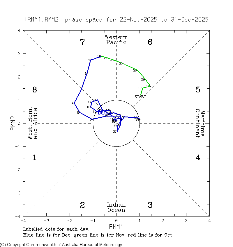
As we look ahead to Jan, here’s the wrap for Dec MJO: the last 12 days (12/20-31), which covered the torch period, turned out to track in 7-6-4-3-5, not well predicted by the models and which is typically not a cold path and can easily be mild: The coldest day of the month in the E US was during phase 8 and phase 8 overall was the typical cold. It never was able to get into 1 and instead took a detour across eventually to 5! Nothing even close to that had been predicted. Remember all of those endless ph 8 progs?
-
I think some Nina winters are just a struggle to get precip. I think I noted in for my winter ideas (back in June) that fall should be dry. IMBY, we have done ok. West of me....not so much. Some Nina patterns can be the exact opposite of dry. There is a bank of analogs which brings flooding rains after fall and into spring and the next summer. I would expect, especially w/ Nino incoming over the summer, that the drought situation should moderate by late summer at the latest. Modeling has been generally honking that we should see increased moisture over the next two months, but I am not holding my breath as it "appears" they are struggling to handle even the EPO ridge at almost short range.
-
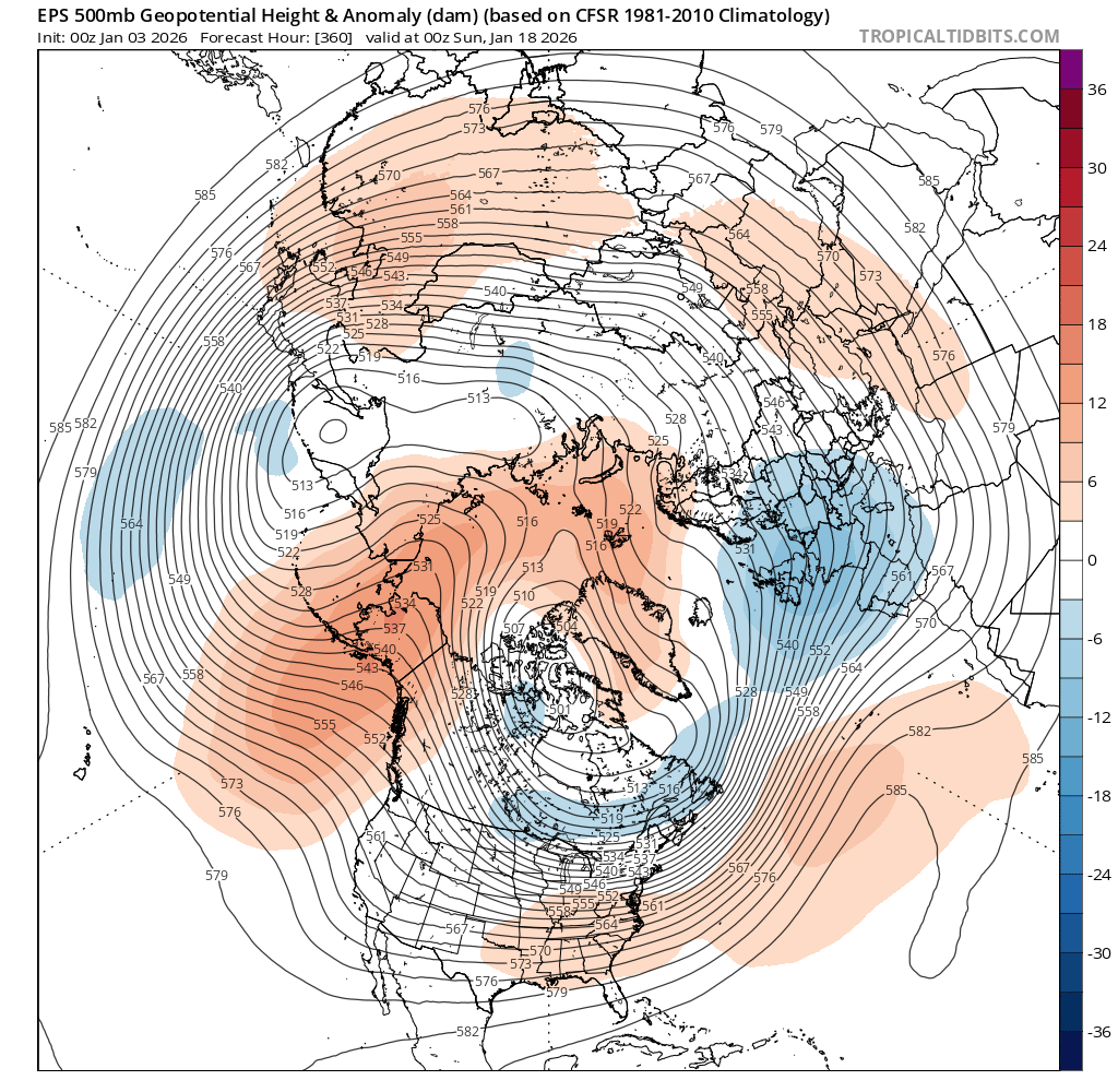
The reason for these Chi coldest of run posts is because of it being a source region since a lot of SE cold travels from that area. It’s extremely hard for the SE to get colder than Chi (outside of mtns) as the air traveling from there modifies as it comes SE and even more w/o snowcover.Whereas the 0Z GFS suite stayed the same (quite mild) as the 12Z despite the Euro suite getting sig. colder post Jan 6th, the 6Z GFS suite did trend a notable amount colder even though it’s still mainly mild (normal lows upper teens) (ens means are the most important that far out) Coldest post Jan 6th of GFS/GEFS:12Z +30/+250Z +29/+256Z +21/+21
-

January 2026 regional war/obs/disco thread
HoarfrostHubb replied to Baroclinic Zone's topic in New England
When I was up around 5:30 to let the dog out, we had some flakes. might be all we get this upcoming week -

E PA/NJ/DE Winter 2025-26 Obs/Discussion
Birds~69 replied to LVblizzard's topic in Philadelphia Region
Looks to be a wintry looking day. Clouds and temps in the 20s and low 30s. Maybe a couple snow showers overnight? Dusting? Car topper? 23F -

January 2026 Short/Medium Range Thread
Holston_River_Rambler replied to John1122's topic in Tennessee Valley
I was thinking the 6z GFS wasn't too far off from a similar soultion: A little progressive, but it is the GFS. Might be worth my time to look at individual ensemble members. -

January 2026 regional war/obs/disco thread
Kitz Craver replied to Baroclinic Zone's topic in New England
Heavy, heavy traces -

January 2026 regional war/obs/disco thread
codfishsnowman replied to Baroclinic Zone's topic in New England
I think you and Will are rock star caliber. I have over 15 years on this board and I think you two are about the best in this forum. Wiz is following right in your footsteps and for two someones who technically aren't mets Steve and Ray know SNE weather like the back of their hands and are rarely wrong. It really is a privilege to belong to this forum. I have been fascinated by weather since I was a kid but I just didn't have the accumen for the math and science. -

January 2026 regional war/obs/disco thread
Baroclinic Zone replied to Baroclinic Zone's topic in New England
Teeny weenie grab. AIT, it’s meh. -
January 2026 regional war/obs/disco thread
Kitz Craver replied to Baroclinic Zone's topic in New England
GEPS really flexing that SE ridge. That look has some risk -
I know it doesn't impact east TN, but I'll take what the 6z AI Euro is suggesting for 1/13/26. Decent 2-3" for northwest middle TN on that run. Hopefully some mischief is being sniffed out here.
-
Last nights Op Euro was the coldest run in days
-

Winter 2025-26 Medium/Long Range Discussion
Baum replied to michsnowfreak's topic in Lakes/Ohio Valley
SUNDAY NIGHT MOSTLY CLOUDY IN THE EVENING, THEN BECOMING PARTLY CLOUDY. A SLIGHT CHANCE OF FREEZING RAIN IN THE EVENING. NEAR STEADY TEMPERATURE IN THE UPPER 20S. SOUTH WINDS 5 TO 10 MPH. CHANCE OF PRECIPITATION 20 PERCENT. -

January 2026 regional war/obs/disco thread
dendrite replied to Baroclinic Zone's topic in New England
GEFS, EPS, GEPS all start having that +TNH look toward d15…SE ridge, ridge off west coast, lower heights SW US and up toward Hudson Bay. We’d play with fire with that, but I’d roll with my chances in the interior for a higher QPF SWFE.
-

January 2026 Short/Medium Range Thread
Weatheriscool replied to John1122's topic in Tennessee Valley
Hopefully it is cold and wet, we didnt get anything from that rain yesterday, it all slid south of us, the dryness continues -
TT is Celsius and Weather Bell is Fahrenheit, hence minor temp differences are accentuated on WB.
-
If January through March repeat what we had in December most would have 30 to 40"
-

January 2026 regional war/obs/disco thread
WxWatcher007 replied to Baroclinic Zone's topic in New England
-

Winter 2025-26 Medium/Long Range Discussion
A-L-E-K replied to michsnowfreak's topic in Lakes/Ohio Valley
Zzzzzz -

January 2026 regional war/obs/disco thread
Damage In Tolland replied to Baroclinic Zone's topic in New England
I don’t think many will see 2”.. but ORH hills or maybe Se MA with a little ocean influx -

January 2026 regional war/obs/disco thread
Sey-Mour Snow replied to Baroclinic Zone's topic in New England
Tonight really dried up, (never looked impressive but it's worse now) looks like if Kevin is lucky he can get a half inch in the Tolland Hills, coating for everyone else .. -
January 2026 regional war/obs/disco thread
dendrite replied to Baroclinic Zone's topic in New England
What’s your reasoning for 2? -

January 2026 regional war/obs/disco thread
Krs4Lfe replied to Baroclinic Zone's topic in New England
Ideally, you would want the ridge closer towards Idaho and Utah, which would force deeper anomalies closer to the east coast as opposed to a deeper trough in the Great Lakes, which can usually signal more clippers and a fast northern stream. Either way it’s a lot better than what will be in place next week and it doesn’t seem to be being pushed back at all. - Today
-
January 2026 regional war/obs/disco thread
Krs4Lfe replied to Baroclinic Zone's topic in New England
I’ll probably blow torch for a week, especially here closer to the mid Atlantic. The models are generally honing in on a pattern change around the 11th or the 12th but obviously we should not expect any immediate chances for snow because the pattern change will have to set in first before the chances actually come. Hopefully that pattern changes here to stay because with a properly timed SW during cold anomalies in January, which is already peak Climo, we could do very well. -
Winter 2025-26 Medium/Long Range Discussion
Baum replied to michsnowfreak's topic in Lakes/Ohio Valley
Yup. Just had a week of pure winter. 20’s and two dusters. Long long way to go in these parts. Of course, if your banking on endless days of cold and snow that rarely happens in these parts. Seen winters where the first real snow didn’t hit until a foot on the last day of January. Actually going to enjoy the 40’s and hopefully a salt washer at weeks end. Probably, snow 20” after next week to close out the month.