All Activity
- Past hour
-

Feb 22nd/23rd "There's no way..." Storm Thread
wasnow215 replied to Maestrobjwa's topic in Mid Atlantic
The problem is that's a worse model than GFS especially at this range lol once it gets inside three hours it's terrific -

Central PA Winter 25/26 Discussion and Obs
MAG5035 replied to MAG5035's topic in Upstate New York/Pennsylvania
It looks like they are factoring the NBM in pretty heavily into their forecast, which is probably the best move right now. That’s a comparison of the regular NBM and the v5 NBM which is the parallel one that is eventually going to be the regular operational NBM this spring. The v5 version doesn’t incorporate SREF due to its impending retirement I believe at the end of the year. Actually I’ll just show the relevent slide from NOAA’s presentation on the v5 as to the differences in it and how the blend is made up. https://vlab.noaa.gov/documents/6609493/7858320/NBMv5.0+Overview+for+Evaluation.pdf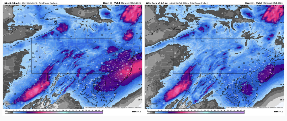

-
I mean it already caved from nothing to a light to moderate event. At this point GFS wins unless it misses and all lose.
-
They are very similar. It's just timing. 2-3 hr. difference .
-

“Cory’s in NYC! Let’s HECS!” Feb. 22-24 Disco
40/70 Benchmark replied to TheSnowman's topic in New England
Oh, sure...GFS had 71mb yesterday. -
Verified. Heavy rain continued off and on thru the night. Set a new rainfall record of 1.21", breaks old mark of 0.80" from 2012 (although that was all snow, lol). Currently still mod to heavy rain (another 0.12-0.15 in CoCoRaHS gauge since 7 am) and 41.8/41.1 degrees.
-

“Cory’s in NYC! Let’s HECS!” Feb. 22-24 Disco
Cyclone-68 replied to TheSnowman's topic in New England
How strong will the winds be for eastern areas? Any coastal flooding concerns? -
“Cory’s in NYC! Let’s HECS!” Feb. 22-24 Disco
40/70 Benchmark replied to TheSnowman's topic in New England
Yea, same....probably going to hold off on a first map until late tonight. -

“Cory’s in NYC! Let’s HECS!” Feb. 22-24 Disco
RUNNAWAYICEBERG replied to TheSnowman's topic in New England
Good vibes though, we’ll take the scraps and continue piling to the seasonal. -

Central PA Winter 25/26 Discussion and Obs
Blizzard of 93 replied to MAG5035's topic in Upstate New York/Pennsylvania
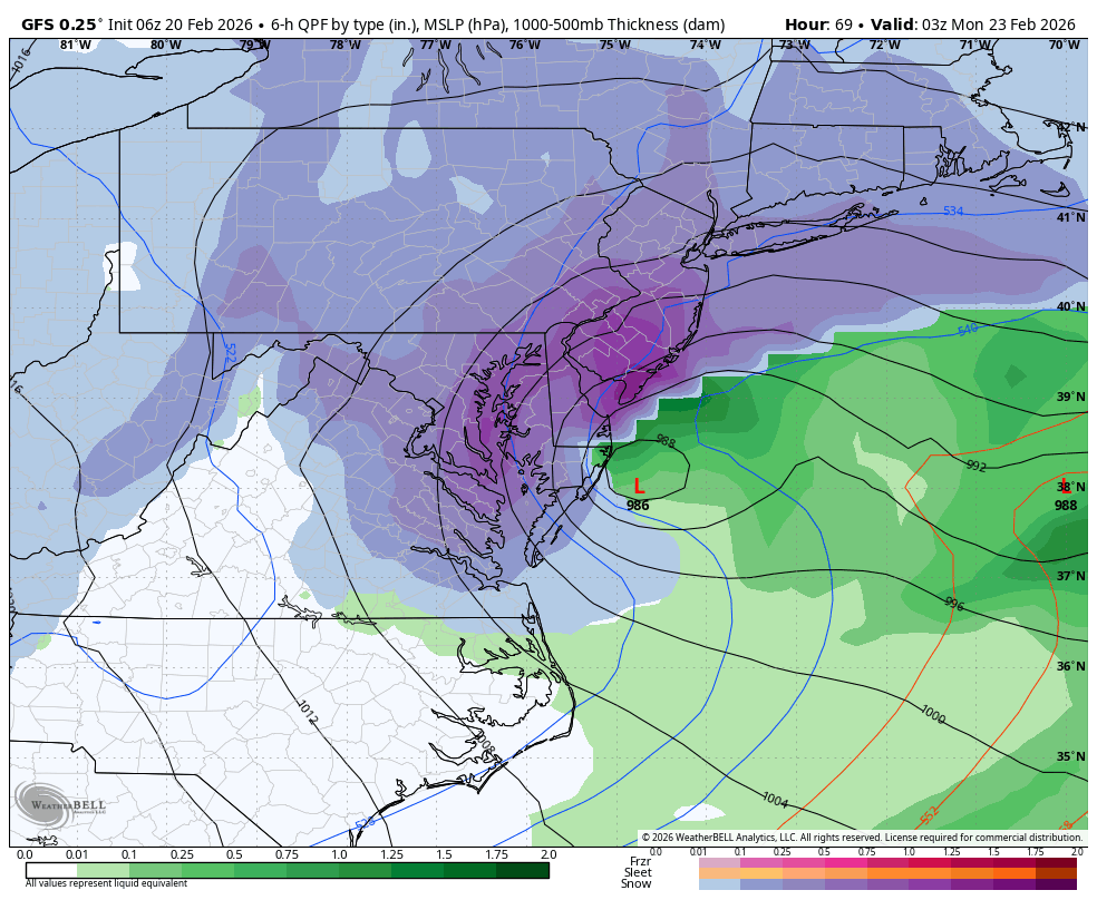
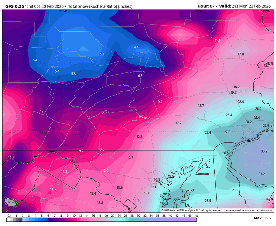
6z GFS shows another tucked low just off of OCMD, bringing heavy snow potential to the LSV again this run.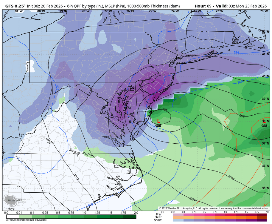
-
Parents and grandparents do and they’re always asking me what the weather is going to do so I follow there just as close as here lol
-

“Cory’s in NYC! Let’s HECS!” Feb. 22-24 Disco
Go Kart Mozart replied to TheSnowman's topic in New England
I wasn't clear....I meant pressure gradient, 65mbs! -
Yeah…follow it right down here

-
Yea had a glaze on my car, still a mix bouncing off everything.
-
Absolutely pouring in Fairfax City. So dark it looks like 45 minutes before sunrise.
-
“Cory’s in NYC! Let’s HECS!” Feb. 22-24 Disco
RUNNAWAYICEBERG replied to TheSnowman's topic in New England
Yea we need a march 17-like inside d2 nw trend. Stabilization now doesnt so much for us, just makes forecasting amounts easier lol. -
You live down there? I remember tracking from afar and just seeing the euro cave to them close in, but I couldn’t confirm that
-
“Cory’s in NYC! Let’s HECS!” Feb. 22-24 Disco
40/70 Benchmark replied to TheSnowman's topic in New England
Must be pretty far west given the track. -
The srefs do that 20 times a season.
-

Feb 22nd/23rd "There's no way..." Storm Thread
NorthArlington101 replied to Maestrobjwa's topic in Mid Atlantic
If I don’t get at least 6” the only thing the GFS will get is hate -
Central PA Winter 25/26 Discussion and Obs
Blizzard of 93 replied to MAG5035's topic in Upstate New York/Pennsylvania
Absolutely too early to call this one. Wide model discrepancy especially between the GFS & Euro. -
They’re not even worth discussing. However, the fact that one NBM member is a huge hit gives me a clue we MIGHT see the 12z Nam go crazy
-
Getting that low to Cape May's latitude is what we need.
-
.thumb.png.4150b06c63a21f61052e47a612bf1818.png)
“Cory’s in NYC! Let’s HECS!” Feb. 22-24 Disco
HIPPYVALLEY replied to TheSnowman's topic in New England
WOR crowd needs bigger trends that stick. I’m not getting sucked in to this, yet. -

Central PA Winter 25/26 Discussion and Obs
GrandmasterB replied to MAG5035's topic in Upstate New York/Pennsylvania
The GFS solution went from weenie wishcasting to having the NAM and SREFS on its side plus the AI’s are just a little too east with the coastal (but have trended west). Euro and UKIE with no coastal storm impact. We pretty much get another day of constant model watching one way or the other!