All Activity
- Past hour
-
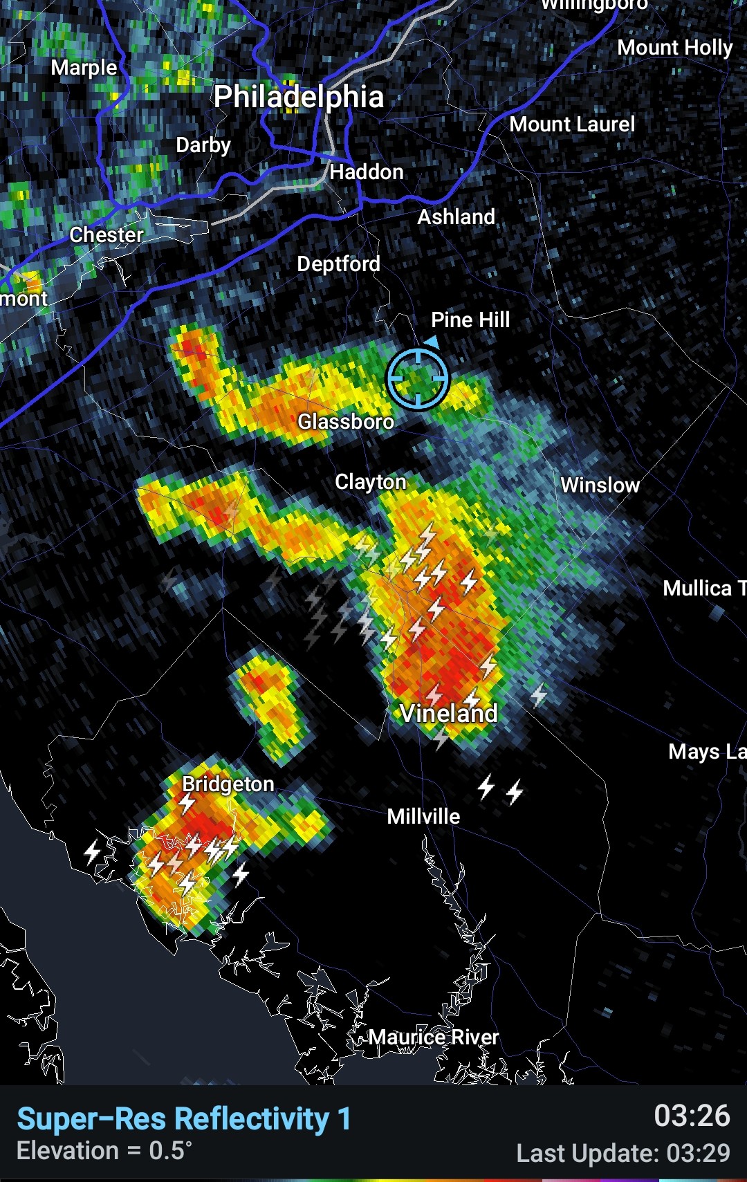
Lotta purple showing up on 3k for Tuesday.
-
Hazardous Weather Outlook National Weather Service State College PA 618 AM EDT Mon Jun 30 2025 PAZ004>006-010>012-017>019-024>028-033>037-041-042-045-046-049>053- 056>059-063>066-011030- Warren-McKean-Potter-Elk-Cameron-Northern Clinton-Clearfield- Northern Centre-Southern Centre-Cambria-Blair-Huntingdon-Mifflin- Juniata-Somerset-Bedford-Fulton-Franklin-Tioga-Northern Lycoming- Sullivan-Southern Clinton-Southern Lycoming-Union-Snyder-Montour- Northumberland-Columbia-Perry-Dauphin-Schuylkill-Lebanon-Cumberland- Adams-York-Lancaster- 618 AM EDT Mon Jun 30 2025 This Hazardous Weather Outlook is for central Pennsylvania. .DAY ONE...Today and tonight. Strong to severe thunderstorms capable of producing damaging winds and heavy rainfall are possible this afternoon and evening. .DAYS TWO THROUGH SEVEN...Tuesday through Sunday. Strong to severe thunderstorms capable of producing damaging winds and heavy rainfall are possible during the afternoon and evening on Tuesday, especially across the Lower Susquehanna Valley.
-

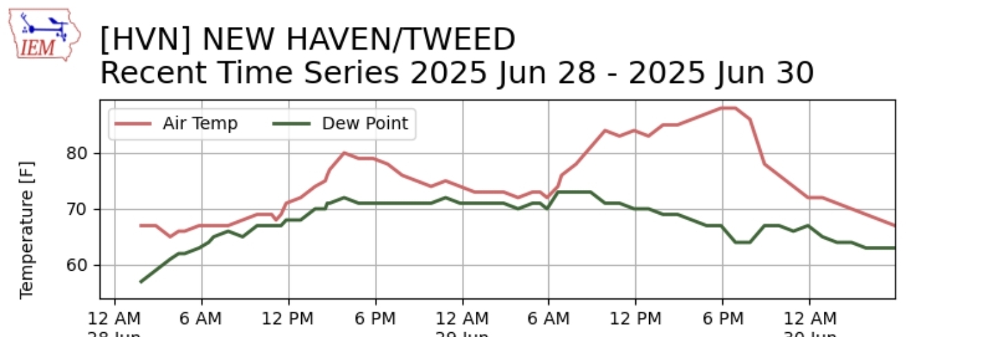
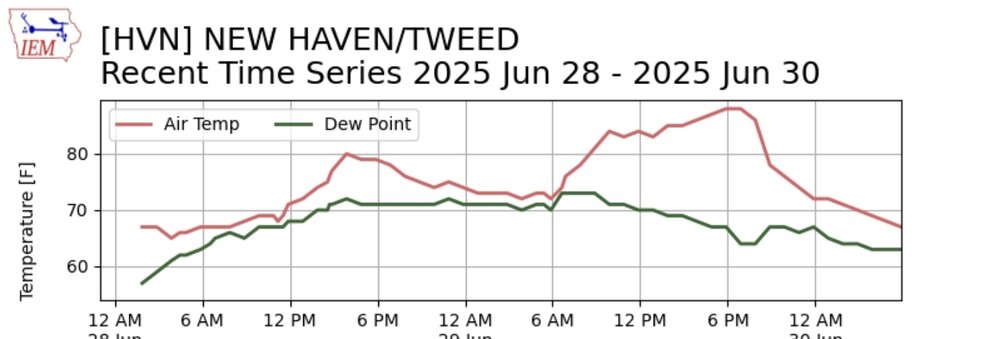
July 2025 Discussion-OBS - seasonable summer variability
IrishRob17 replied to wdrag's topic in New York City Metro
The last weekend without any sort of precipitation IMBY was 3/7-3/9/25…could the first weekend in July finally end that streak? -
64 degrees this morning. 5.15 “ for the month of June so far, which puts us above average. Normal value 3.72” 89 degrees yesterday
-
Emphatically agree. My brother discovered a dead one in his kid's play area scattered among their stuffed animals/toys and had to do a rabies course for the whole family. Not a pleasant experience. Cost him a couple thousand bucks, and his insurance was billed a couple hundred thousand.
-
Need to be in and up for the 3x it snows and matters in winter
-
You need to move down to the shoreline. Just got back from another special 5 miler along the shoreline. Expect a typical warm and humid summer day region wide. The region will be just north or along the northern periphery of a stalled frontal boundary to the immediate south. Dew point readings will be primarily in the middle and upper 60s through the early afternoon. A sea breeze gets going for the afternoon and will usher in slightly higher moisture values with dew points approaching 70 late in the day and evening along far southern locations
-
56.4° Should be toasty this afternoon.
- Today
-
66/63. Deep summet run
-
Looks like the WAR tries to build in end of 11-15 day. Would be similar to what we’ve had in recent summers with no extreme temps, but humid and very warm to hot potentially.
-
64 luckily. No 50s nonsense.
-

E PA/NJ/DE Summer 2025 Obs/Discussion
BBasile replied to Hurricane Agnes's topic in Philadelphia Region
Finally got a proper heavy downpour after dodging all the storms this morning. They did make for a nice looking sunrise, though..thumb.jpg.0d80b70cccf47db44fc8b2d2f6e570f9.jpg)
-
55/54 just brutal out
-
4th should be low 80s in SNE. Maybe 75-80 where the dragons be.
-
I bet most will say the GFS is right for the 4th and the Euro is trash
-
0z colder again
-
 +1.7 __ +1.5 __ +1.3 __ +1.2 __ +2.0 __ +2.0 ___ +0.3 __ +1.5 __ +0.7 June scoring is back in thread, everyone did well so there won't be big changes in the annual scoring race which I will update in another "back in thread" post set aside to take on that work (before all July forecasts except wxdude64's early submission) ...
 -
 July DCA _ NYC _ BOS ___ ORD _ ATL _ IAH ___ DEN _ PHX _ SEA 2.2 2.3 2.5 2.2 1.7 2.5 1.6 0.2 1.8
 -

Central & Eastern Pacific Thread
Stormchaserchuck1 replied to Windspeed's topic in Tropical Headquarters
Already on "F" in the eastern Pacific, and it's expected to become a Cat 2, ultimately heading just west of Baja California -
July pattern matching the global trend, making recent Winter analogs more relevant to this coming Winter
-
2025-2026 ENSO
Stormchaserchuck1 replied to 40/70 Benchmark's topic in Weather Forecasting and Discussion
It's more about the 91-20 average, and how we are trending compared to it. The first list of years was July 1981-1990. There is -3F on the West coast from that 10-year period. The second list of years was 2021-2024, there is +4F in the same spot.. I'm pointing out that in July there is a +5-6F trend on the west coast compared to 91-20 averages, and that July pattern per current modeling is setting up again, and strong. The 82-83 Strong El Nino is a [minus] in the composite, meaning opposite of it. And 23-24 is [plus], but even in Strong El Nino's, I'm pointing out that the July trend is actually stronger than what a Strong El Nino has produced. It's a point about about the recent global pattern and consistencies from year to year. If July is verifying, it means that recent previous Winter trends are probably more relevant this coming Winter. -
2025-2026 ENSO
Stormchaserchuck1 replied to 40/70 Benchmark's topic in Weather Forecasting and Discussion
Good post. Very interesting. It looks like a phase started in 2013 with the EA. I have said many times that I started noticing an Atlantic-Pacific correlation in 2013, where cold season -NAO's were coinciding with more -PNA/+EPO and +NAO's were coinciding with more +PNA/-EPO. I theorized that it has something to do with the Summer Arctic ice melt, and us not breaking through 2007-2012 levels relative to the global warming. It's like the NAO is "capped" and the potential energy is spilling into other parts of the globe (just my theory). Also 1998 was a big jump up in the EA and that is exactly when the -PDO phase started. The most linear chart I have ever seen, with less flux, is Germany winter snowfall from 50-60 years ago to present. The line almost fits a perfect -30 degree angle. I wonder if the EA index will ever have a negative phase, it appears to be at highest levels all time in 23-24. Upper latitudes should match mid-latitude warming, but that hasn't happened so much lately. AO and NAO and EPO blocks were still higher in the 50s, 60s, 80s, etc. While we keep seeing record breaking ridging 30-50N. I think the NAO not going to record high levels in its blocks is allowing the SE ridge to occur underneath of it, and ridging in Europe, because the base pattern should favor more extreme upper latitude blocks and it's not occurring, if that makes any sense. -
E PA/NJ/DE Summer 2025 Obs/Discussion
BBasile replied to Hurricane Agnes's topic in Philadelphia Region
Finally getting some rain. Only have 1.05" on the month up until now.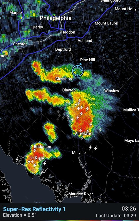
-
There was a lot in my yard tonight too.
-
I have them in my shutters that face south. I remember painting the shutters one year and two flew out, I almost fell off the ladder.