All Activity
- Past hour
-

2025-2026 ENSO
40/70 Benchmark replied to 40/70 Benchmark's topic in Weather Forecasting and Discussion
Agreed on both accounts. I simply distinguishging between an ostensible La Nina, and an actual event per CPC guidelines. -
 I guess the season is even shorter for the sea-faring lads. Those cold ocean breezes can make a day that is nice inland, miserable on the water?
 -
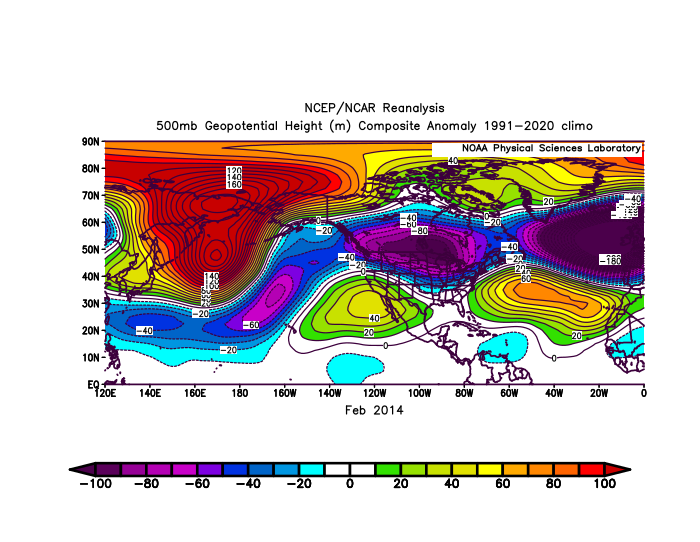
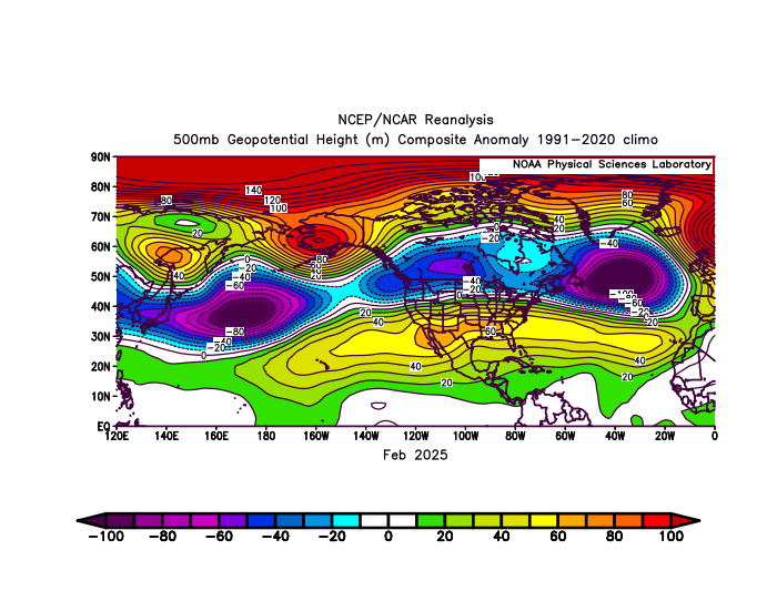
The higher latitude ridge near Greenland was not any more further north than in the past when had KU snowstorm tracks as the comparison to 2014 snowed. But what changed is that the subtropical ridge was too far north. So the gradient got pushed to our north with the heavy snows.
-
Time to retire...
-
https://phys.org/news/2025-08-broken-japan.html
-
Your reply echoes my comment...
-

2025-2026 ENSO
Stormchaserchuck1 replied to 40/70 Benchmark's topic in Weather Forecasting and Discussion
You can see how there was a parade of troughs though just below the Polar regions. Wavelengths tightened up and it put a ridge underneath of it, but there was some very cold air in the Midwest this last February. And Japan had a pretty cool Winter. Why do you think now we have somewhat permanent ridging in the mid-latitudes? You keep saying -5 AO, but it's simple wave physics: the ridge was too far north! That pattern is not a mystery to me. -
Last February would have been a much better pattern for the area around NYC if this mid-latitude ridge from Hawaii to Bermuda wasn’t so overpowering. It muted the -EPO -WPO and Greenland block influence. Back in February 2014 the -WPO-EPO and Greenland block was able to dominate so it was much snowier around NYC. February 2025 had the first -5 AO and -5 SD Greenland block cutter that gave record snows to Toronto and Montreal instead of around NYC Metro.
-
It’s a little hazy here, but most of it seems aloft right now.
-
Record high min at TRI yesterday. One thing I have noticed is that the point-and-click forecasts have been way too high all summer(at range) for MBY. I had mid-upper 90s forecast for much of last week(early and middle). If I remember correctly, 93 was as high as it got. The Apple wx app has been more accurate.
-
2025-2026 ENSO
Stormchaserchuck1 replied to 40/70 Benchmark's topic in Weather Forecasting and Discussion
A 90N ridge will create a trough most likely around 45N. Sometimes a stronger relative trough will happen at 45-50N, and on the east or west side of that there will be mid-latitude ridging. That's what happened in February. the North Atlantic trough under a 90N ridge (Atlantic trough at 45-50N) was -300dm, and for latitude/height, a greater anomaly. I get that the Pacific pattern looks more independent of the +AO, but it does correlate to -PNA -
I wouldn’t say the +AO is driving it since the ridge in the North Pacific beneath the -EPO and ridge north of Alaska is even stronger than the one we just had under the +AO in the Northeast. We have seen the ridge in the Northeast with the record -5 AO back in February. So while the higher latitude teleconnections shift around, this mid-latitude ridge has been the one constant.
-
2025-2026 ENSO
Stormchaserchuck1 replied to 40/70 Benchmark's topic in Weather Forecasting and Discussion
^Negative anomaly max is almost greater in that image! Why not say "The +AO is at least partially driving it"? The +AO that has appeared much more frequent after the major solar flares staring in May 2024. That's a big negative anomaly on your map, bluewave. Relatively though the ridge near Japan is probably 1.4x greater. -
59/56
-
I got a golf tournament Tuesday-Thursday in Keene. Will I even be able to see my golf ball?
-
Low of 57. Beautiful sunrise.
-
Boston -7.1F for the 3 days. That ain't going to last.
- Today
-
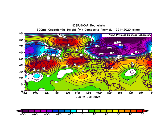
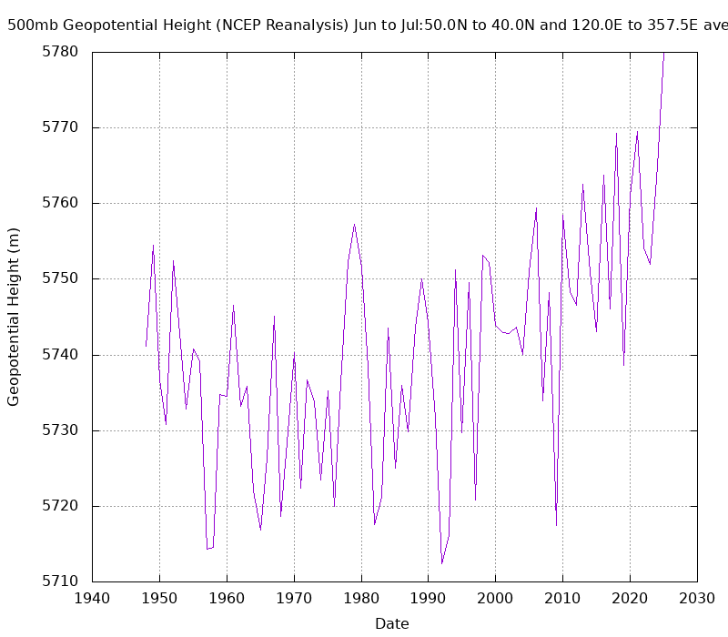
Whatever we decide to call it, this June and July featured the strongest continuous 40N mid-latitude ridge from Japan across the U.S. and North Atlantic to Europe that we have seen before. It’s what’s ultimately driving these record -PDO values and record warmth around the Northeast this summer. This ridge has been much stronger than we have ever seen from past La Ninas or -PDO patterns.
-
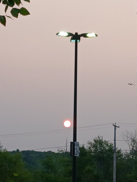
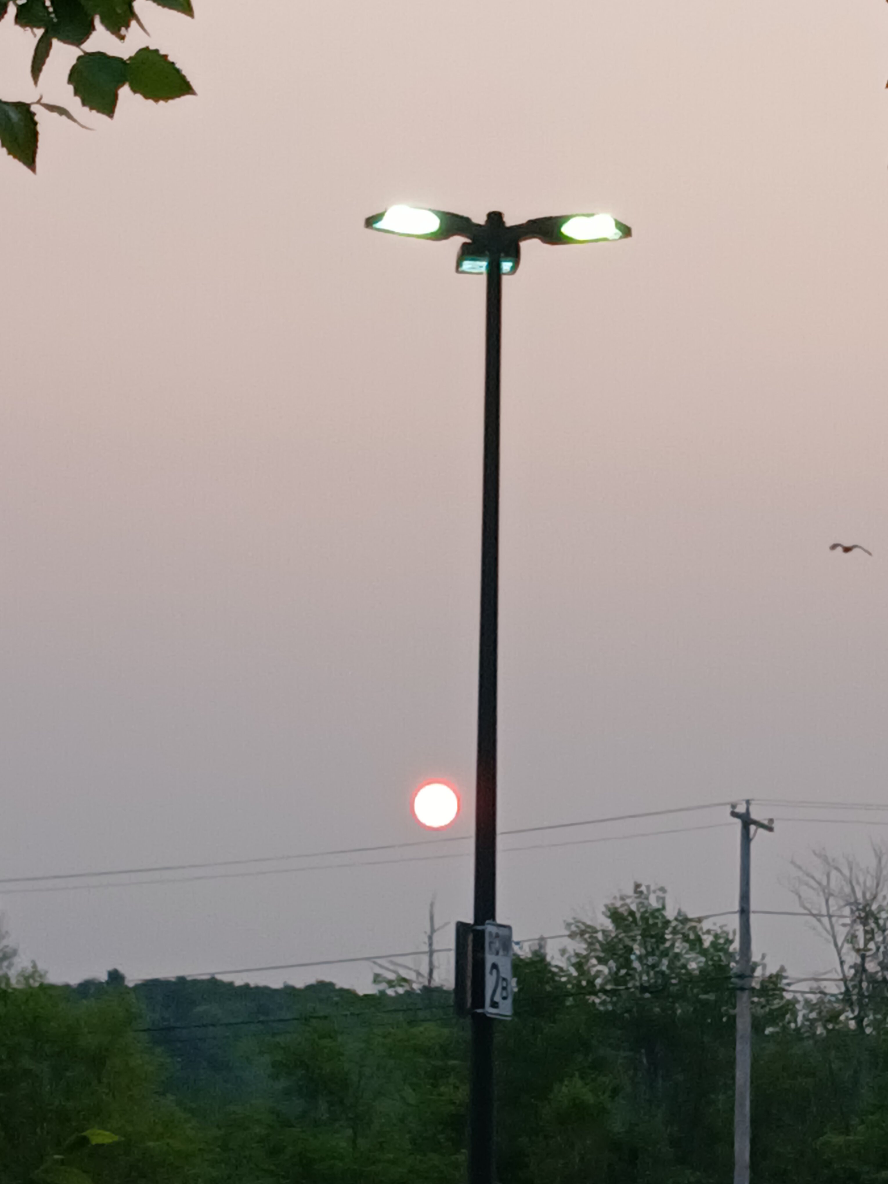
Just pulled in a parking lit to take a quick pic.. lots of smoke again today!
-
I think 2 things are blatantly obvious at this point…1) We are going to have a -ENSO winter, very likely weak La Niña regardless of what the “official” ONI number says 2) We are going to have a solidly (very possibly strong) -PDO winter….
-
Just wait till you see the sun this morning.
-
 It was only the 2nd 80° behind 2010. But it felt warmer this time around since the dewpoints were so much higher. The average max finished just behind 2010. Time Series Summary for JFK INTERNATIONAL AIRPORT, NY June 21st through July 31th AVG Temp Click column heading to sort ascending, click again to sort descending. 1 2010-07-31 80.7 0 2 2025-07-31 80.0 0 3 2020-07-31 78.5 0 4 2013-07-31 78.4 0 - 2011-07-31 78.4 0 5 2012-07-31 78.2 0 6 2019-07-31 78.1 0 - 1949-07-31 78.1 0 7 2016-07-31 78.0 0 8 2024-07-31 77.6 0 - 2015-07-31 77.6 0 - 2002-07-31 77.6 0 9 1993-07-31 77.5 0 10 2022-07-31 77.4 0 - 1999-07-31 77.4 0 - 1983-07-31 77.4 Time Series Summary for JFK INTERNATIONAL AIRPORT, NY June 21st Through July 31st Max AVG Temp Click column heading to sort ascending, click again to sort descending. 1 2010-07-31 89.2 0 2 2025-07-31 87.6 0 3 2011-07-31 86.5 0 4 2019-07-31 86.3 0 - 1966-07-31 86.3 0 5 2012-07-31 86.1 0 - 1963-07-31 86.1 0 - 1949-07-31 86.1 0 6 2020-07-31 86.0 0 7 2002-07-31 85.9 0 8 2013-07-31 85.6 0 9 1993-07-31 85.5 0 10 2016-07-31 85.3 0 - 1983-07-31 85.3 0
 -
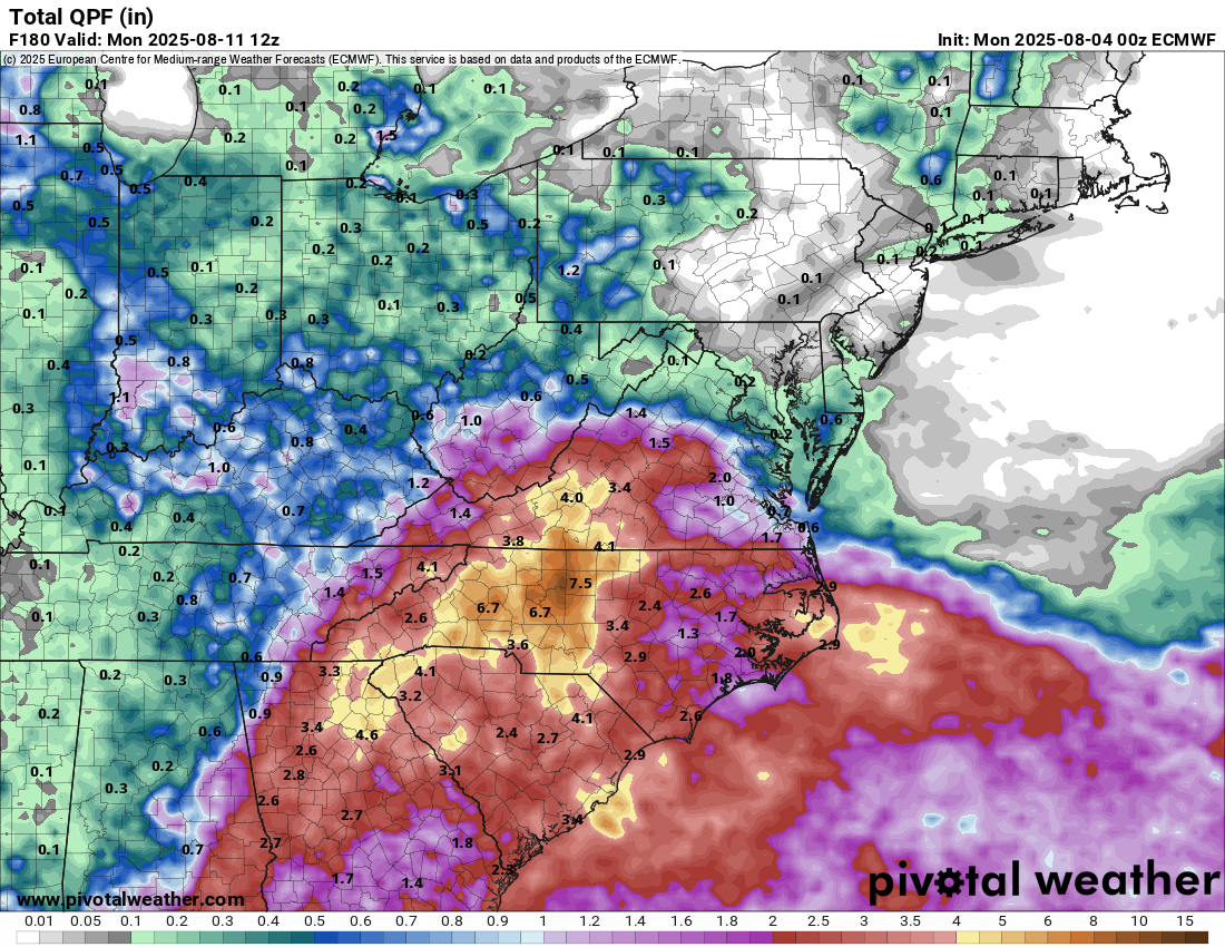
The next week looks wet, quite a big of variability on just how wet
.thumb.png.0d009d29cbe71b026fa103e6fe928533.png)

-
Sizzler

-
Currently 59 imby. 37 at Canaan NWR.


.png.e6ab1b6c28862b9171fe97821b1488e9.png)