All Activity
- Past hour
-

E PA/NJ/DE Autumn 2025 Obs/Discussion
Ralph Wiggum replied to PhiEaglesfan712's topic in Philadelphia Region
Ahhh the Feb 89 debacle. Sophomore in high school. Schools shut down night prior in anticipation. Me and my buddy split a quarter of some good afghani bud. Started walking around the town 8AM. By 11AM we thought maybe we were both just really stoned but there wasnt a snowflake to be had and sun was poking thru. Stopped off for pizza at noon and the workers said we dodged one but the shore was getting hit. Mega pissed. We smoked the rest of our stash and enjoyed our day off, but it was still a huge letdown. - Yesterday
-
This won’t come anywhere close to the western basin but it may add some ACE: Tropical Weather Outlook NWS National Hurricane Center Miami FL 800 PM EDT Sun Oct 12 2025 For the North Atlantic...Caribbean Sea and the Gulf of America: Central Tropical Atlantic (AL97): Showers and thunderstorms have increased in association with a small area of low pressure located about 900 miles west-southwest of the Cabo Verde Islands. Environmental conditions are forecast to become more favorable for further development of this system during the next few days, and a tropical depression is likely to form by the middle part of this week while it moves to the west-northwest then northwest at 15 to 20 mph across the central tropical Atlantic. * Formation chance through 48 hours...medium...60 percent. * Formation chance through 7 days...high...70 percent. $$ Forecaster Blake Also, of more importance landfall potential-wise, a followup AEW has been forecasted by a number of runs and ensemble members to develop close to the Lesser Antilles in ~a week.
-
 Now we can begin to see how this might play out as that new low grabs the offshore precip to its north and throws it on shore over NJ and the metro later.................
 -

The return of the elusive Nor'easter. Drought buster or bust?
yoda replied to dailylurker's topic in Mid Atlantic
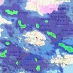
That's a weird looking radar -

The return of the elusive Nor'easter. Drought buster or bust?
JenkinsJinkies replied to dailylurker's topic in Mid Atlantic

-
Sitting at .02”. Looks like Boston is getting the goods. Oh well.
-
 I will say that there's a low of the Carolinas with new one forming by delimarva
 -
.thumb.jpeg.f5c6ba9d911ec96b3b124f8606aee58e.jpeg) Up to 0.73” of rain in the bucket
Up to 0.73” of rain in the bucket -
Noticeable uptick in wind at the beach now. Feels a bit more NE/ENE vs NNE all day. Sustained 47, gusts to 57 mph out on Barnegat Inlet
-
Idk I'm cooking i can't look cook and eat lol I'm adhd,I might burn the house down
- 475 replies
-
- 1
-

-
- heavy rain
- damaging wind
- (and 2 more)
-
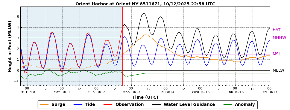
This surge model forecast versus actual is spot on! GFS Based Guidance (ETSS)
-
where are the other low centers located ? you can actually see the LP in Del Marva on radar as the precip west of it is moving from the northeast to southwest
-
Just got back from a miserable coast trip with rain and wind, and cold. Beautiful sunny day and 82 degrees here in ATL area!
-
Thanks for your genius expertise
-
New low is forming right now and strengthening by delmarva
-
As long as we’re posting stuff that nobody cares about I’ll go- I live in Vista, NY in the point of Westchester that juts into CT. If you’ve ever been to Vista you might wonder why the name if there is no view in Vista? This area was almost completely deforested in the 1700 and 1800’s for dairy farms for NYC and the view to Long Island and the Sound was said to be spectacular. People would travel to take in the view and picnic hence the name. Around the turn of the 20th century the dairy farms were gone and the trees grew. So why post this on a weather board? Our trees are all the same age 100+ years and it doesn’t take much to cause havoc -multi day power outages: 4 days Irene, 6 snowtober, and 9 for Sandy! So away from the coast it still matters.
-
You see it more commonly now with it looking like a NASCAR event on any highway. For an example, the Palisades parkway and around Stony Point, the Bear Mountain Traffic Circle, route 6 extension areas, it’s a plethora of driving styles that make up a recipe for disaster and accidents occurring almost daily.
-
 No. It'll just be lucky guesses at this point and someone will be right. Things are kinda verifying on the coast and LI, but just inland, the cutoff remains very sharp. Precip might be filling back in a bit offshore the last few frames. So far it seems even the areas east of 95 are also underperforming as far as the precipitation goes. Wind is more the story.
- 475 replies
-
- 1
-

-
- heavy rain
- damaging wind
- (and 2 more)
-
 HRRR has an extended period (4-6 hours or so) of spotty showers and then steadier rain moves back in a bit later tonight. As for winds, it should increase a bit as well as the low moves up and occludes (nothing to write home about though).
- 475 replies
-
- 1
-
-
- heavy rain
- damaging wind
- (and 2 more)
-
Yeah but is has been stale under Harbaugh for awhile. While they have won a lot in the regular season- they have been front runners that blow teams out while often losing the closely contested games, with a good chunk of those being leads blown late. On top of that they underachieve in the postseason. Just saying, don't let it get to the point where changes aren't made until its too late- i.e. multiple losing seasons. Despite the injuries, this team should NOT be 1-5 at this point. Something is seriously lacking.
-

The return of the elusive Nor'easter. Drought buster or bust?
WxUSAF replied to dailylurker's topic in Mid Atlantic
It’s raining! -
anybody fiqure out the future of this storm yet ? Precip field in NJ over Monmouth and Ocean Counties is shrinking also winds here in north central NJ are reduced from earlier
-
Over 1000, without power pseg long island already
-
 Radar has changed in the last few frames. Moisture streaming east to west across Suffolk now. Winds have picked up here so I think that secondary low is starting to have an impact up here now
- 475 replies
-
- 1
-

-
- heavy rain
- damaging wind
- (and 2 more)