All Activity
- Past hour
-
Summer Solstice. My summer starts June first.
-
Didn’t someone say 6z Euro qpf was usually right the day before?
-
Yep, huge differences here. Some of the area got 1/3-1/2 inch (0.34 here), then a stripe from far western Alleghany up into southern Bath county got like 2-3 inches. Pushed Dunlap creek up 2-2.5 feet and Jackson river up a foot or so (and muddy) with rest of creeks and rivers in area barely moving.
-
Up to 59° and the rain is mostly light. All in all pretty nice day.
-
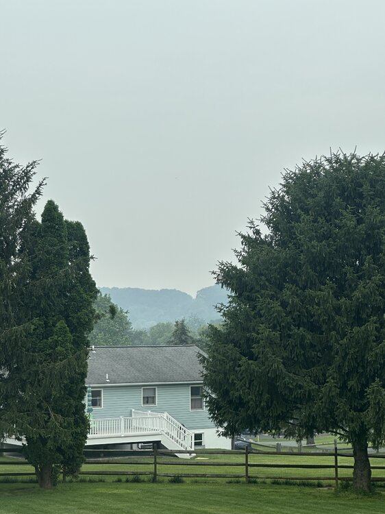
Same here, low visibility all things considered and a strong smell of smoke. Weekends have had clouds and rain here 11 out of 15 , now add nasty smoke particulates.
-
It’s bad up here.
-
1953 had a historically hot summer for us too, with two legendary historic heatwaves with 4 100+ degree days spread evenly between them and even a historic severe wx outbreak with an F4 tornado in Worcester, MA!! 1953: The warmest June on record occurred in Oklahoma City, OK. The main part of the heat wave extended from the 11th through the 21st, and seven of the daily high temperatures during that stretch remain records for their respective dates. June 14th was the hottest day, reaching a toasty 106°. The other records ranged from 100° to 105°. Even the nighttime lows were records. Eight daily minimum temperatures from June 1953 are still record-warm daily minimum temperatures, ranging from 75° to 80°. (Ref. Wilson Wx. History)
-
days and days of suffering

-
Thursday could be even hotter than this past Thursday was! Friday is the first day of summer.
-
July 2011 had historic heat. About July 2013 that was one hot month, I remember July 4th was very stuffy, big heat and no wind lol. That was the last time PHL hit 100 too wasn't it?
-
historic heat that summer too!!
-

2025-2026 ENSO
PhiEaglesfan712 replied to 40/70 Benchmark's topic in Weather Forecasting and Discussion
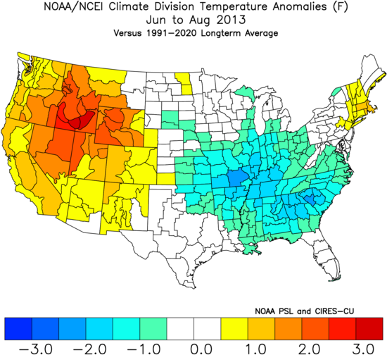
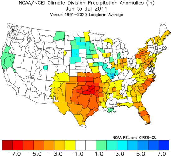
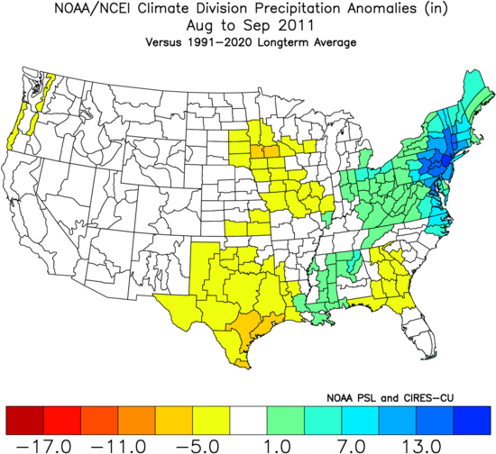
2013 was a frontloaded summer at best. That one was pretty much done by 7/21. It's the only August without a 90+ day here in PHL in the last 40 years. Outside of that super heat wave in July, 2013's summer temperature stats were nearly identical to 2014 (with June and August both years differing by 0.1 2010-2012 had widespread heat in the East: I don't see that with 2013 (which in fact looks cool in the Southeast): Of course, that was a much stronger la nina. The first year was a strong la nina, and the second a moderate la nina. Not to mention, a deepening -PDO and a pattern that changed at the start of November. Everything that could go wrong, went wrong, which is why we had the torch we had from November 2011-March 2012. (I don't see any similarities with now. In fact, I see much more similarities with 2013 than with 2011. Like now, we are much closer to ENSO neutral and a solar max in 2013. Definitely not what we had in 2011.) 2011 was dry in June and July. The record rains were in August and September.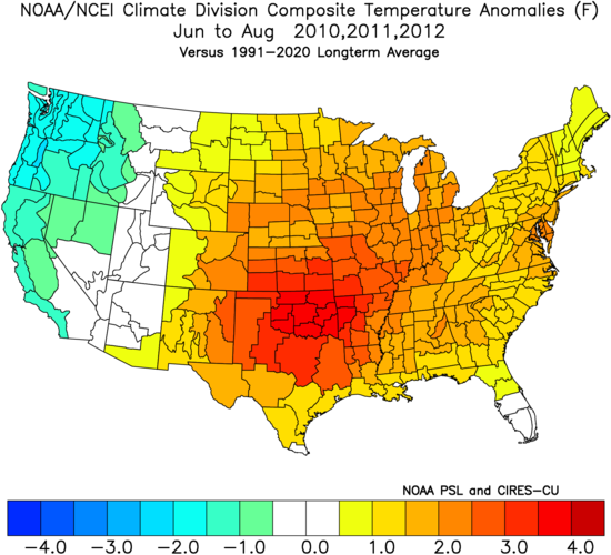
-
Stein finally came.
-
.03 lol. Not wet a bit under the trees. Just about over too . Stein showing life
-
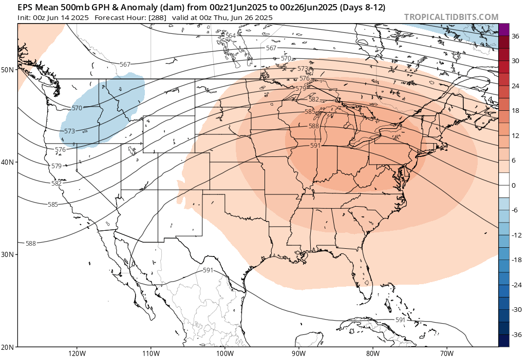
EPS has a nice NW flow look as heat dome builds east. Let’s pray for violence.
-
Here is the academic publication related to Google's new cyclone model. [Alet et al. 2025]
-
Nice October weather today. Won't get many days like this, wish it happened during the week vs weekend though.
-
No rain in Maytown so far for the event.
-
0.07
-
The next week is spotty rains Sat-Mon then some overnight showers storms Wed- and scattered storms Thu-FRi,
-
Only saving grace is while cool and cloudy we should avoid the heaviest rains these next 72 hours.
-
The official high temperature was 57 yesterday in Minneapolis. Warming trend begins today.
-
Records: Highs: EWR: 99 (1988) NYC: 99 (1956) LGA: 99 (1956) JFK: 95 (2005) Lows: EWR: 49 (1978) NYC: 49 (1875) LGA: 51 (1978) JFK: 52 (1980) HIstorical: 1886: Many people were lost when high seas from a hurricane inundated the area near Sabine, TX. (Ref. Wilson Wx. History) 1903 - The Heppner Disaster occurred in Oregon. A cloudburst in the hills sent a flood down Willow Creek, and a twenty foot wall of water swept away a third of the town in minutes, killing 236 residents and causing 100 million dollars damage. (David Ludlum) 1953: The warmest June on record occurred in Oklahoma City, OK. The main part of the heat wave extended from the 11th through the 21st, and seven of the daily high temperatures during that stretch remain records for their respective dates. June 14th was the hottest day, reaching a toasty 106°. The other records ranged from 100° to 105°. Even the nighttime lows were records. Eight daily minimum temperatures from June 1953 are still record-warm daily minimum temperatures, ranging from 75° to 80°. (Ref. Wilson Wx. History) 1957: An F4 tornado moved across the south and southeast sides of Springfield, IL. The tornado destroyed 25 homes and severely damaged 175 others; property damage was around $3 million dollars. On the north side of town, the storms produced a wind gust of 98 mph at Capital Airport, which still stands as Springfield's record wind speed. Two people died during the storm, with over 50 others injured. A separate tornado touched down in downtown Jacksonville, destroying or damaging 40 buildings. East St. Louis, IL recorded the state record for rainfall in 24 hours with 16.54 inches. (Ref. Wilson Wx. History) 1961 - The temperature in Downtown San Francisco, CA, soared to 106 degrees to establish an all-time record for that location. (The Weather Channel) 1974: A tornado took an intermittent 53 mile long path across northwest and west central Illinois. The tornado first touched down just southeast of the Quad Cities, and moved southeast into Knox County. In Abingdon, 200 homes were damaged or destroyed. (Ref. Wilson Wx. History) 1987 - Thirty-two cities in the central U.S. reported record high temperatures for the date. The high of 97 degrees at Flint, MI, tied their record for June, and the high of 101 at Milwaukee WI marked their first 100 degree reading in 32 years. Thunderstorms brought much needed rains to South Texas, drenching McAllen with 3.2 inches in one hour. A thunderstorm soaked the town of Uncertain with 2.3 inches of rain in one hour. (The National Weather Summary) 1988 - Thirty cities in the eastern U.S. reported record high temperatures for the date. (The National Weather Summary) 1989 - Thunderstorms developing ahead of a cold front produced severe weather from the Central Gulf States to the Middle Atlantic Coast Region during the day and into the night. There were 62 reports of large hail and damaging winds. Thunderstorm winds caused 28 million dollars damage in Montgomery County MD. (Storm Data) (The National Weather Summary) 1990: Shadyside, OH was destroyed by a wall of water up to 30 feet high causing 26 fatalities. The flooding was caused by 4 inches of rain that fell in just 75 minutes. Localized, excessive rainfall fell on saturated ground over southeastern Ohio during the evening, resulting in a 15 to 20 foot wall of water that raced down three small tributaries of the Ohio River. (Ref. Wilson Wx. History) 1994: Norfolk: a bolt of lightning struck and critically injured a 50-year-old woman and a 38-year-old man playing in a golf tournament at Greenbrier Country Club in . Both suffered severe burns. 1998: On June13th and 14th Boston, MA had 5.99 inches precipitation the greatest in a 24 hours for June. (Ref. NOAA Boston Weather Events) and Atlantic, Iowa, set a state record for daily precipitation, measuring 13.18 inches of rain. (Ref. Wilson Wx. History) 2010: During June 14, training thunderstorms associated with a nearly-stationary cold front and an intense low-level jet brought torrential rains to the Oklahoma City, Oklahoma, area. Six to nine inches of rain in little more than three hours caused flash floods, resulting in more than three dozen water rescues. The North Canadian River at Oklahoma City rose from eight feet to over 21 feet almost instantly during the morning of June 14, Oklahoma City's wettest day on record (7.62 inches).
-
Super smoky.
-
No sign of any smoke down here in the swampy lowlands. We didn't get a ton of rain last night, less than 1/2". But it's wet and soupy out. Good moth weather.