All Activity
- Past hour
-
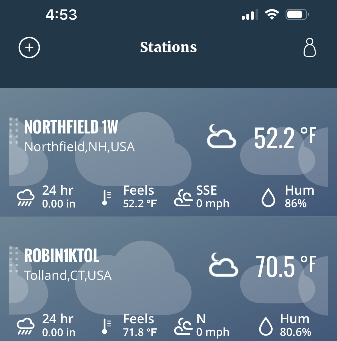
Min 51.9° Skyrockets in flight in a few hours
-
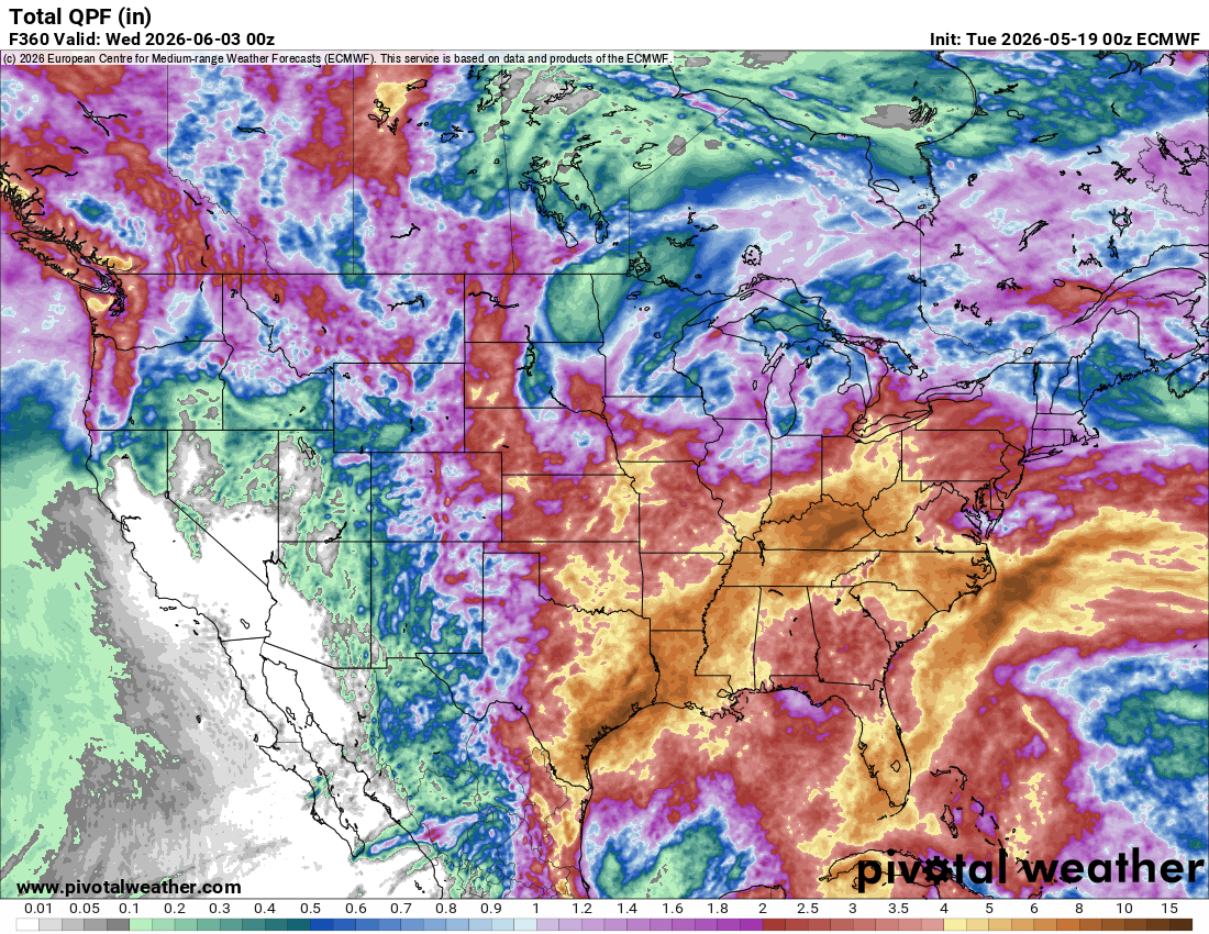
Euro has showers for Saturday and Sunday
-
-
Just as I expected. All those storms that were supposed to start around Wednesday, are now pushed out until MAYBE Sunday in my area. Drought continues to get worse.
-

Chester County PA - Analytical Battle of Actual vs. Altered Climate Data
chubbs replied to ChescoWx's topic in Climate Change
You continue to carefully pick your facts. There are many other days in the chart I posted when Phoenixville had excessive temperatures vs West Chester and Coatesville. For instance: July 22, 1934, Phoenixville 101, West Chester 86, Coatesville 88; or July 13, 1936, Phoenixville 100, West Chester 85, and Coatesville 86. In the 2 months that I posted Phoenixville had 9 days over 100, while West Chester and Coatesville only had 2. Finally the West Chester and Coatesville sites were also warm in this period. Both located in built-up towns. Unlike any site we have today. Very unrepresentative of Chester County as a whole. Our learnings in Chester County help in interpreting Martz chart: 1) Phoenixville shows that non-aspirated shelters can experience large spurious jumps in 90/95/100F days, and 2)Coop stations had frequent moves. In Chester County stations moved out of towns to cooler locations with time. Comparing Martz chart to the local data. He has fewer hot days in recent years vs Philadelphia and Chester County indicating a cooler station population overall. Meanwhile he has more hot days than Philadelphia or Chester County in the early years, an indication that factors 1 and/or 2 above are present in his data set. I'd like to see the individual station data before drawing any firm conclusions. As we have seen in Chester County simple aggregation of raw COOP data without careful inspection leads to misleading charts.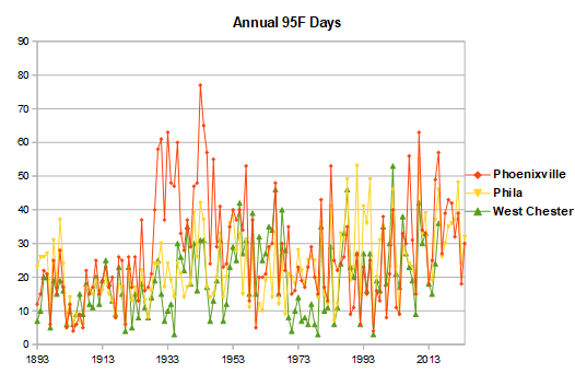
-
Models sort of cancelled tomorrow but have more of a threat today near pike and north.
-
Tonight may even end up a few degrees warmer
-
Ha wow. But those mid to Upper 70s show how torches it is aloft.
-

Central PA Spring 2026 Discussion/Obs Thread
Voyager replied to Voyager's topic in Upstate New York/Pennsylvania
Yesterday's Tamaqua high was 94 degrees. -
There are some wild 4am temps out there. What the hell.
-
Dayum Ditty
-
Is all hope lost for this weekend? Sad.
- Today
-
6z nam looks good for storms today
-
The easiest cure for the gypsy moth infestation? Pretend they're something else.
-
93 yesterday, 95 forecasts today, 96 forecasts for Wednesday.
-

2026-2027 Strong/Super El Nino
MJO812 replied to Stormchaserchuck1's topic in Weather Forecasting and Discussion
Of course next winter will be warmer. This winter was one of the coldest winters in a long time in the east. -
2026-2027 Strong/Super El Nino
MJO812 replied to Stormchaserchuck1's topic in Weather Forecasting and Discussion
That doesnt have anything to do with what will occur 7 months from now. These long range forecasts have to end. They are rarely right. Its fun to do one though. -
Long range 500mb pattern, keeps the anomalous heat, west of NE, for the foreseeable future, after Wednesday.
-

Central PA Spring 2026 Discussion/Obs Thread
canderson replied to Voyager's topic in Upstate New York/Pennsylvania
Endicott Arm / Dawes glacier. Last pic is two whales playing! -
Noted GFSX MOS did not have BOS any higher than 66 Thu-Mon. Scott looking forward to SCT FROST in SNE Fri AM?
-
Ran my air conditioning for the first time this year, today. Was 87 degrees. That's July weather. Still, one of the later times I've had before needing to turn the A/C on for the first time. It's the warm/humid nights that caused it. The house can get really cool on those dry nights when it gets down in the lower 50s, so much so that it doesn't heat up enough during even an 85 degree day, enough to need the A/C. I avoided it Sunday for that reason, it was 49 Sunday morning.
-
Actually, all of the CAMs this evening suggest scattered convection in the area Tuesday evening which is nice to see.
-
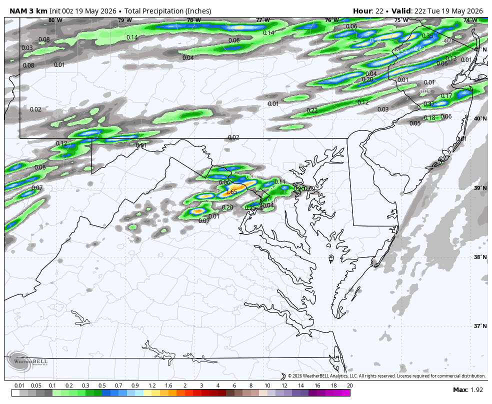
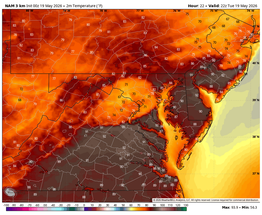
WB 0Z 3K NAM has scattered thunderstorms late Tues. afternoon which knocks down the record heat.
-
Shameless! Lol


.thumb.gif.f92b16c631a1d15d405ed77b33f0710d.gif)