All Activity
- Past hour
-
Rain! Got the outflow boundary intersection just right. Over 0.50” in a day for the first time since mid-July.
-
Trying again near Nokesville/Bristow area?
-
Getting a few rumbles with darkening skies. Hopefully it'll hold together.
-
Starting with Kevin ?
-
That's it? Gosh I thought you were going to get more then that, maybe tomorrow?
-
I've never considered the sky from a grasshopper's perspective before. Fascinating.
-

Saturday 9/6 Strong/Severe storm potential
Torch Tiger replied to Torch Tiger's topic in New England
definitely an embedded sup in there. Was getting anvil lightning from that 20 minutes ago, same thing now. Very impressive even missing it -
TDS?
-
Thought Temp would drop...nope 82/71, home Davis showing .26" brightning to my west, swamp ass continues!
-

September 2025 OBS-Discussion centered NYC subforum
psv88 replied to wdrag's topic in New York City Metro
0.05” with that line. There were some decent wind gusts to around 35 and few claps of thunder -

Saturday 9/6 Strong/Severe storm potential
WxWatcher007 replied to Torch Tiger's topic in New England
Nammy did good...Nammy did good. -
Looks like it’s a little too tipsy compared to others. Always a local max. Hmm.
-

September 2025 OBS-Discussion centered NYC subforum
doncat replied to wdrag's topic in New York City Metro
0.59" in short time with gust to 39 mph... didn't hear any thunder though. Also snuck up to 90° earlier. -
Another dumping flooding downpour. My area is a magnet for storms this season. If there's a chance, it's happening here lol.
-
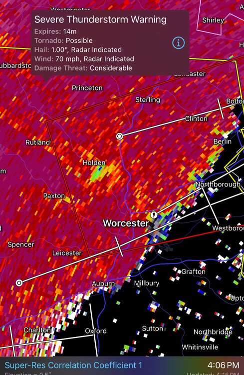
Hearing on Holden FD dispatch of damage near Bailey Rd, power lines off houses; looks to be in line with the area of rotation coming from Paxton along Rt 31
-

Saturday 9/6 Strong/Severe storm potential
Baroclinic Zone replied to Torch Tiger's topic in New England
Yeah! That’s him. -
That blows. 0.38" and looks to be done soon. Sent from my SM-S921U using Tapatalk
-
Another area of broad rotation just NE of Kev near Ashford on 84
-
looks to be still some rotation with the Holden cell. Going to come really close to here so definitely watching it.
-
Just came my closest ever to a lightning bolt, and I've experienced some close ones. Was at a softball practice in Ludlow, and the tumultuous sky, darkening off to the northwest and north had my attention-- and checking the NWS saw there was a tornado warned cell to the northwest. So practice over I decided to try a little intercept for whatever might be, and was driving my appropriately named F150 Ford Lightning north along Lyons street towards Granby with the front windows open. That route affords some pretty good views off to the west, and I could see the ragged lined edge of the rain off there, but though under forbidding skies-- not a drop yet where I was. Then, I swear, not 20 or 30 feet off, directly to the right out my front side window a sizzling bolt-- bamm-- and I could feel the shock of it- or was it just the adrenaline buzz of such a close hit? Just reminder again that especially in dynamic developing situations, bolts out of the blue can and do happen. I continued on, a half mile or so further, then another close bolt, and then blotto, visibility down to near zero. As I write back home in Monson, we just had another strike not far to the south that got our dog's attention. All in all I would say aside being ground zero in the May microburst, this has been the most consequential thunderstorm event in a summer that has been woefully lacking in such.
-

2025 Atlantic Hurricane Season
BarryStantonGBP replied to BarryStantonGBP's topic in Tropical Headquarters
Nah mate go to spec savers innit Gefs and eps stalls the mjo in phase 8/1 like if it’s your annoying nan Wcar and gulf show a shit ton of moisture being pulled in within 10-12 days so the atmosphere turns from Karachi to Phuket mjo enhances convection in the western part of the basin in comes Gabby and the burrito innit -

Saturday 9/6 Strong/Severe storm potential
Chrisrotary12 replied to Torch Tiger's topic in New England
Is that thing tornado warned because people live there? -

September 2025 OBS-Discussion centered NYC subforum
FPizz replied to wdrag's topic in New York City Metro
Wow, im at 1.12" -
.thumb.png.4150b06c63a21f61052e47a612bf1818.png)
Saturday 9/6 Strong/Severe storm potential
HIPPYVALLEY replied to Torch Tiger's topic in New England
Dick Hertz from Holden? -

September 2025 OBS-Discussion centered NYC subforum
Snowlover11 replied to wdrag's topic in New York City Metro
dont feel bad same here.


