All Activity
- Past hour
-
Globalism and all its wonderful side effects. I lost a 60 year old Ash tree to the Emerald Ash Borer. It was a gorgeous tree with a beautiful canopy that provided tons of shade and a beautiful fall foliage.
-
That has not been my experience- we’ve lost almost all our ash in the last 10 years and now beech leaf disease is killing all the beech!
-

Occasional Thoughts on Climate Change
donsutherland1 replied to donsutherland1's topic in Climate Change
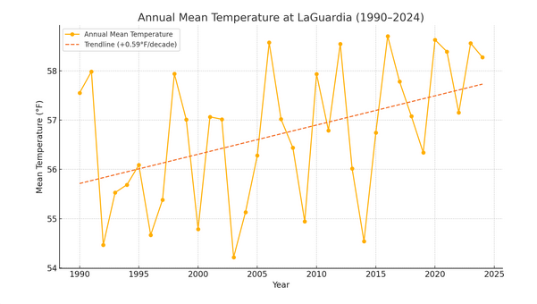
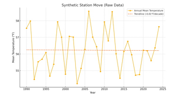
If one is looking for a reliable climate record, adjustments are necessary whenever a station moves. Here's an illustration. Envision a case where one is measuring the temperature in Queens, NY. Assume that the climate record starts in 1990 for purposes of illustration. Temperatures are taken at LaGuardia Airport through 2014. After that, the Queens station moves to JFK Airport. Temperatures are then recorded at JFK Airport through 2024 for purposes of this illustration. If one relied only on raw, unadjusted data, here's what the Queens climate record would look like: There would essentially be no trend in temperatures. Those arguing for the use of unadjusted data would argue that warming is an artifact of statistical adjustments. But here's what things would actually look like: JFK: LaGuardia: The graphs reveal a clear discontinuity in the temperature record when switching from LaGuardia Airport (1990–2014) to JFK Airport (2015–2024), even though they are only 10.9 miles apart. The resulting trend is artificially altered by the change in station location, not by climate. In fact, both stations were warming at similar rates. This simple illustration demonstrates that without adjusting for such moves, the integrity of the climate record ceases to exist. The synthetic station trend is lower than either station individually. In other words, threading the raw data to maintain a continuous climate record creates a badly biased outcome. In sum, station moves introduce biases. To maintain an accurate climate record, data must be homogenized. The data must be corrected for site changes, if one wants an accurate climate signal.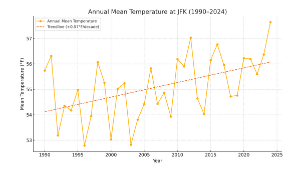
-
Friday morning looks chilly for most of us. Even low 40's down my way.
-
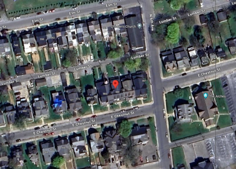
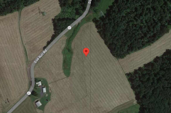
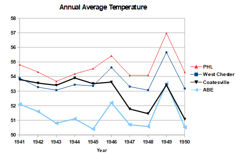
All I know is that you are good at ignoring data that doesn't agree with your worldview. The station move data is unambiguous. Coatesville in 1945 and 1948. Surprised a heat island expert like yourself can't see the difference in these two sites, built up town vs very rural. I certainly wouldn't expect them to have the same temperature. The raw data from surrounding stations allows the effect of the Coatesville move to be determined accurately. This isn't a small change; easy to see the overall effect by comparing the relative position of Coatesville before and after the moves. Before the move, Coatesville was warmer than West Chester and almost as warm as Philadelphia. After the move Coatesville was as cool as Allentown. Roughly 2F cooling overall. Furthermore there many stations other than these 3 that confirm the magnitude of the Coatesville move. It's an open and shut case. We know the when and where of the Coatesville move and we know how Coatesville changed relative to other stations in the region. The evidence for the West Chester move in 1970 is just as strong. Very easy to separate weather from station moves when you know how to do it.
-

Spooky Season (October Disco Thread)
Torch Tiger replied to Prismshine Productions's topic in New England
https://en.wikipedia.org/wiki/1804_New_England_hurricane wish we could gin up a cat 4-5 ish and roll the dice. -

2025-2026 ENSO
so_whats_happening replied to 40/70 Benchmark's topic in Weather Forecasting and Discussion
There is a fairly large system being modeled going into this weekend right over the warm pool region. I think there is forecasted 60-80knot winds already starting to show up across the area. Should definitely help continue carving out the cooler waters and moving that warm pool. As for the Atlantic there is still a decent NW Atlantic warm tongue around Nova Scotia so we should continue to see ridging potential in the region and add the risk of things at times connecting with the SE ridge. Im still rather hopeful that average snowfall can be achieved this year across many areas. RMM plots never fully grasp the intensity of such waves but regardless it should be pretty intense wave to start things off for fall. We are a little off where we were last year at this time for MJO but it looks to follow a similar path and intensity as we did through October last year. Here are the SST anomalies last year as we ended summer and went into fall. The PDO last year had a double dip take place and October values, at the time, were some of the lowest on record.
-
Spooky Season (October Disco Thread)
Torch Tiger replied to Prismshine Productions's topic in New England
Wanna sub for $5.95/mo? -
I do think the pattern coming up will favor slowly moving that warm pool in the central Pacific a bit further east with continued cooling influences east of Japan and along the west coast, at least for the next 2 weeks anyway.
-

E PA/NJ/DE Autumn 2025 Obs/Discussion
Hurricane Agnes replied to PhiEaglesfan712's topic in Philadelphia Region
Well I nickel and dimed my way to 0.38" yesterday with a 2nd round that took me to 0.32" from 0.30", and then another round to 0.38" for the day. This morning I had a surprising 0.08", giving me a grand total of almost 3/4" over 4 days (0.74") and 0.92" for the month so far. It bottomed out at 52 just after 6:30 this morning and hit 67 just before 3 pm for a high, after the skies cleared and the sun came out. Currently cloudy and 60 with dp 55. - Today
-
Blizzarcane!
-
That was a very localized heavy snow event. The ol' upper level low surprise. That map there is closer to reality than the one I ridiculed in the previous post. LOL 6-10"? NO. Was maybe an inch or 2 here. It simply didn't do anything for most of the event and by the time it shifted over this way it rapidly weakened.
-

Spooky Season (October Disco Thread)
Go Kart Mozart replied to Prismshine Productions's topic in New England
I agree, not snow, but the end of the world as we know it.... -
Tomorrow will be partly sunny and milder with highs reaching the middle 60s. However, a fresh shot of cool air will move into the region late in the day or at night. Following the frontal passage, parts of the region could experience their coolest temperatures so far this fall. Dry conditions will likely prevail through the remainder of the week. In the 18 past years where Central Park saw at least two 80° or above highs and Newark saw at least two 84° or above highs during the first week of October, the temperature returned to 70° or above on at least one day during the second half of October in 17 (94.4%) of those cases. For all other cases, 84.1% saw at least one such high temperature during the second half of October. Therefore, the sharp cool spell very likely won't mean that New York City has seen its last 70° or above high temperature. The ENSO Region 1+2 anomaly was -0.1°C and the Region 3.4 anomaly was -0.3°C for the week centered around October 8. For the past six weeks, the ENSO Region 1+2 anomaly has averaged -0.12°C and the ENSO Region 3.4 anomaly has averaged -0.42°C. La Niña conditions will likely continue through mid-winter. The SOI was -3.48 today. The preliminary Arctic Oscillation (AO) was -0.487 today. Based on sensitivity analysis applied to the latest guidance, there is an implied 66% probability that New York City will have a warmer than normal October (1991-2020 normal). October will likely finish with a mean temperature near 58.9° (1.0° above normal). Supplemental Information: The projected mean would be 2.0° above the 1981-2010 normal monthly value.
-

Spooky Season (October Disco Thread)
kdxken replied to Prismshine Productions's topic in New England
That clown is still at it? -

Spooky Season (October Disco Thread)
ineedsnow replied to Prismshine Productions's topic in New England
not snow.. but one more frame of that GFS run might have been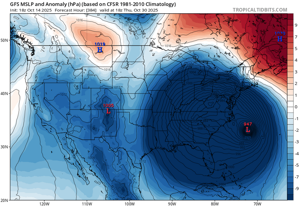
-
sure, if you have a good down parka.....i used to hike all winter, jogged when i was younger. it was cold. very much so.
-
many kids did not do well, i was working in schools at the time. motivated kids did well, others did not, and the data bears this out. but hindsight is 20-20 and there was no playbook for this. over a million dead...the worst results in the developed world. my kids did fine online, but some kids just never logged in.
-
The former. PDO rising in the fall, then falling back into the abyss during spring and summer has become something like a broken record the past few years. I don’t think we will know when it ends until the PDO stays well into positive territory for at least several months.
-
Spooky Season (October Disco Thread)
Torch Tiger replied to Prismshine Productions's topic in New England
Low chance here (or near zero/none realistically) but decent U.S. chance (s) perhaps? there remains plenty 'o ohc to go around, untouched carib. <3 -

Spooky Season (October Disco Thread)
Damage In Tolland replied to Prismshine Productions's topic in New England
Thats kind of what I’m envisioning. Hence “very low” chance .But the pattern progged does allow for something wild potentially -
just to clarify, when you refer to "this shit" (lol), are you referring to the PDO always rising in the fall/winter and falling back down in the spring/summer, or are you referring to the pdo rise right now, and you're saying that the rise can't last forever?
-
I just looked at the animation, and that warm blob ticking east looks like a promising sign. Let’s see if it isn’t just a blip, though. Another good sign is the atlantic isn’t boiling anymore. Most of that basin appears to be near normal, maybe slightly above overall. Re MJO I wonder if the models are under forecasting the amplitude. If this hollmover forecast plot is correct, it’s pretty strong. This pans out, we could see more +PNA this winter… making it more like last year than a blowtorch winter like 2022-23.
-
Spooky Season (October Disco Thread)
Torch Tiger replied to Prismshine Productions's topic in New England
Let's hope for a Sandy/Hazel hybrid that turns to 2' of snow for us! -
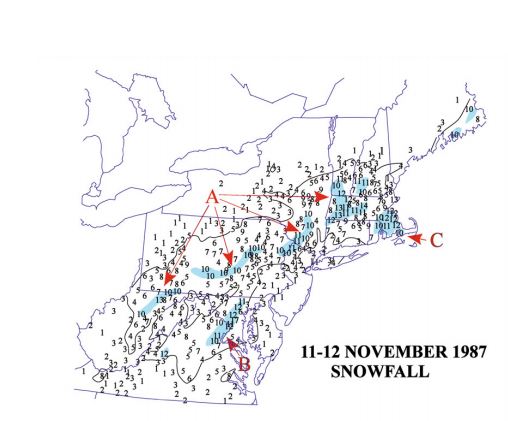
Here you go....-both maps were accurate for me. Took me hours to drive between College Park and Greenbelt. Cars abandoned everywhere. It snowed 3-4 inches an hour with drifts over 2 feet. And it was not forecasted. Mom was freaking out since there were no cell phones back then... National Weather Service @NWS #OTD in 1987, a snowstorm hit the Washington, D.C. area, with up to 17" of snow and stranding cars for nearly 24 hours. The event led to the development of the Washington Metropolitan Area Snow Plan to facilitate preparedness and response. https://weather.gov/lwx/winter_DC-Winters #NWS150 November 11, 1987: The Veteran's Day Storm will not be forgotten by many Washington travelers. Almost a foot (11.5 inches) fell at National Airport. Prince Georges County, MD was hard hit with up to 13 inches of snow falling in a short amount of time. It caught motorists off guard and stranded cars on the Capitol Beltway. There were so many cars that snow plows could not get through to open the clogged arteries. Cars littered the roadway for more than 24 hours. The event precipitated the development of the Washington Metropolitan Area Snow Plan to facilitate preparedness and response to future storms. This storm struck before the days of lightning detection networks and Doppler weather radar. When thunderstorms began dumping heavy snow over the Fredericksburg VA, forecasters had no idea. The storm moved northeast across the southern Metropolitan area (Prince Georges County). It was not until the fast accumulating snow hit Camp Springs, where at the time the Weather Forecast Office was located, did forecasters realize what was happening.