All Activity
- Past hour
-

January 2026 regional war/obs/disco thread
Torch Tiger replied to Baroclinic Zone's topic in New England
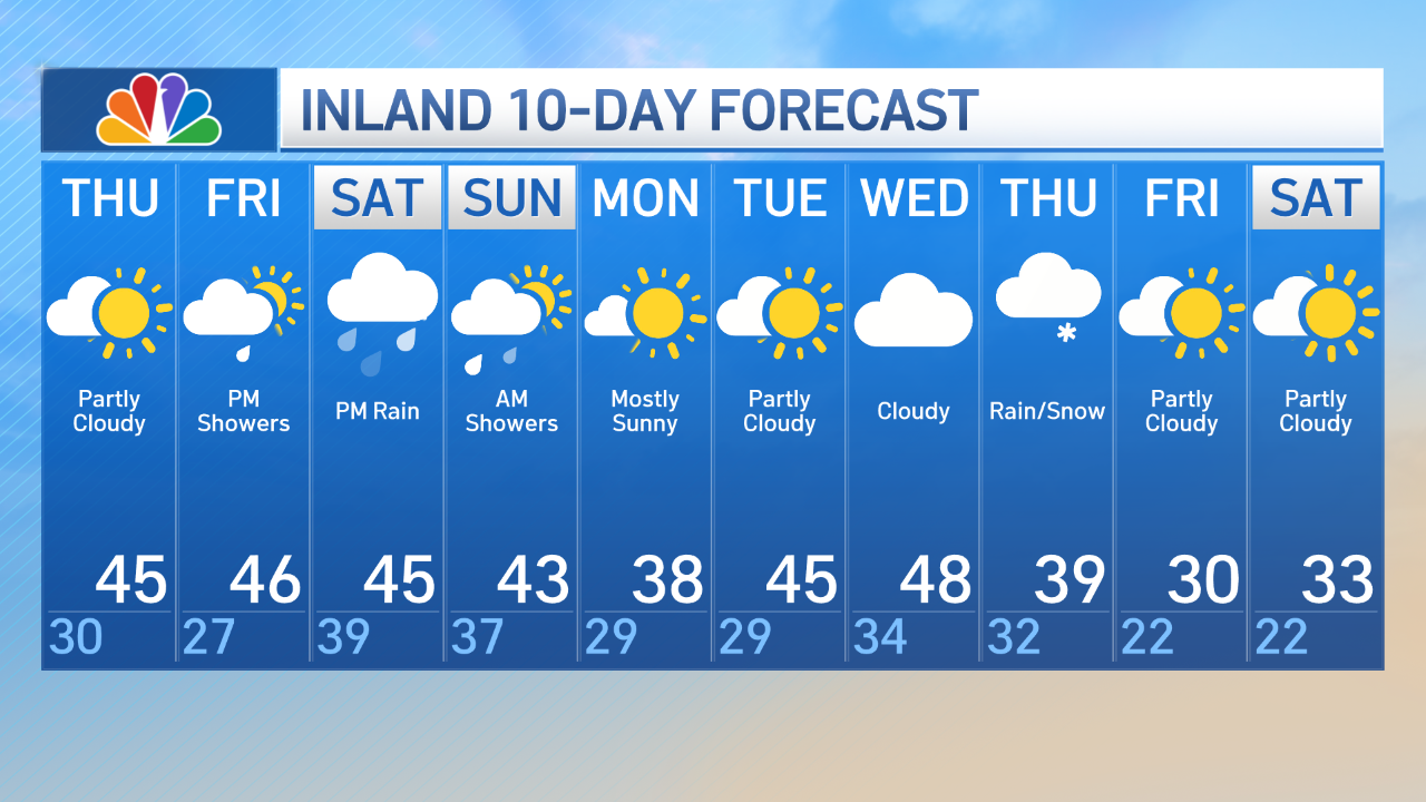
Official recent forecasts? not talking last week's general discussions or thoughts on here, nor was kev. Not a single outlet had 50's that I saw -
A milder pattern is now in place. The remainder of the week will see generally above normal temperatures. Some rain is likely Saturday into Sunday. Rainfall amounts will generally be between 0.50"-1.00". The week will conclude with highs finishing in the 50s across much of the region on Friday and Saturday. Cooler air will likely return Sunday or Monday. No significant Arctic blasts or significant snowfalls are likely through at least mid-January. Afterward, conditions might become more favorable for both cold and snowfall, especially if the PNA goes positive. PNA-related developments would have larger implications for snowfall. A persistently positive PNA would have above climatological risk of moderate or significant snowfalls. A mainly negative PNA would favor mainly small snowfalls. It will likely be a few more days before the guidance reaches the high-skill timeframe for teleconnection forecasts. The ENSO Region 1+2 anomaly was -0.7°C and the Region 3.4 anomaly was -0.5°C for the week centered around December 31. For the past six weeks, the ENSO Region 1+2 anomaly has averaged -0.37°C and the ENSO Region 3.4 anomaly has averaged -0.63°C. La Niña conditions will likely continue into at least late winter. The SOI was +2.31 today. The preliminary Arctic Oscillation (AO) was +0.377 today. Based on sensitivity analysis applied to the latest guidance, there is an implied near 50% probability that New York City will have a cooler than normal January (1991-2020 normal). January will likely finish with a mean temperature near 33.7° (at normal). Supplemental Information: The projected mean would be 1.1° above the 1981-2010 normal monthly value.
-

January 2026 regional war/obs/disco thread
dendrite replied to Baroclinic Zone's topic in New England
Euro still gets 50° up to the Pike Fri night. Would be funny if it maxes out at 5z and goes in the books as 2 days of 50°. edit…that was 12z…18z has a little better caa. -

E PA/NJ/DE Winter 2025-26 Obs/Discussion
Ralph Wiggum replied to LVblizzard's topic in Philadelphia Region
If we can touch 60F, we ride. -
It's tough for me. I like a big storm but, if it's just one and no more I'm more inclined to several light events I guess. However, if it were a true big dog ( foot or more) then probably it.
-
There certainly was! It was fine to discuss the potential as long it was it was kept in the perspective of a long range modeling prediction, and not one that was a lock to happen. And yes, 40's, 50's and even a 60 degree highs were chatted about by many folks. Why deny it... It was discussed and now reality appears to be setting that the high end warming was way overdone... Just another reason to take long lead modeling outcomes with many grains of salt. Fun to chat about but taking it verbatim will often get you burned.
-
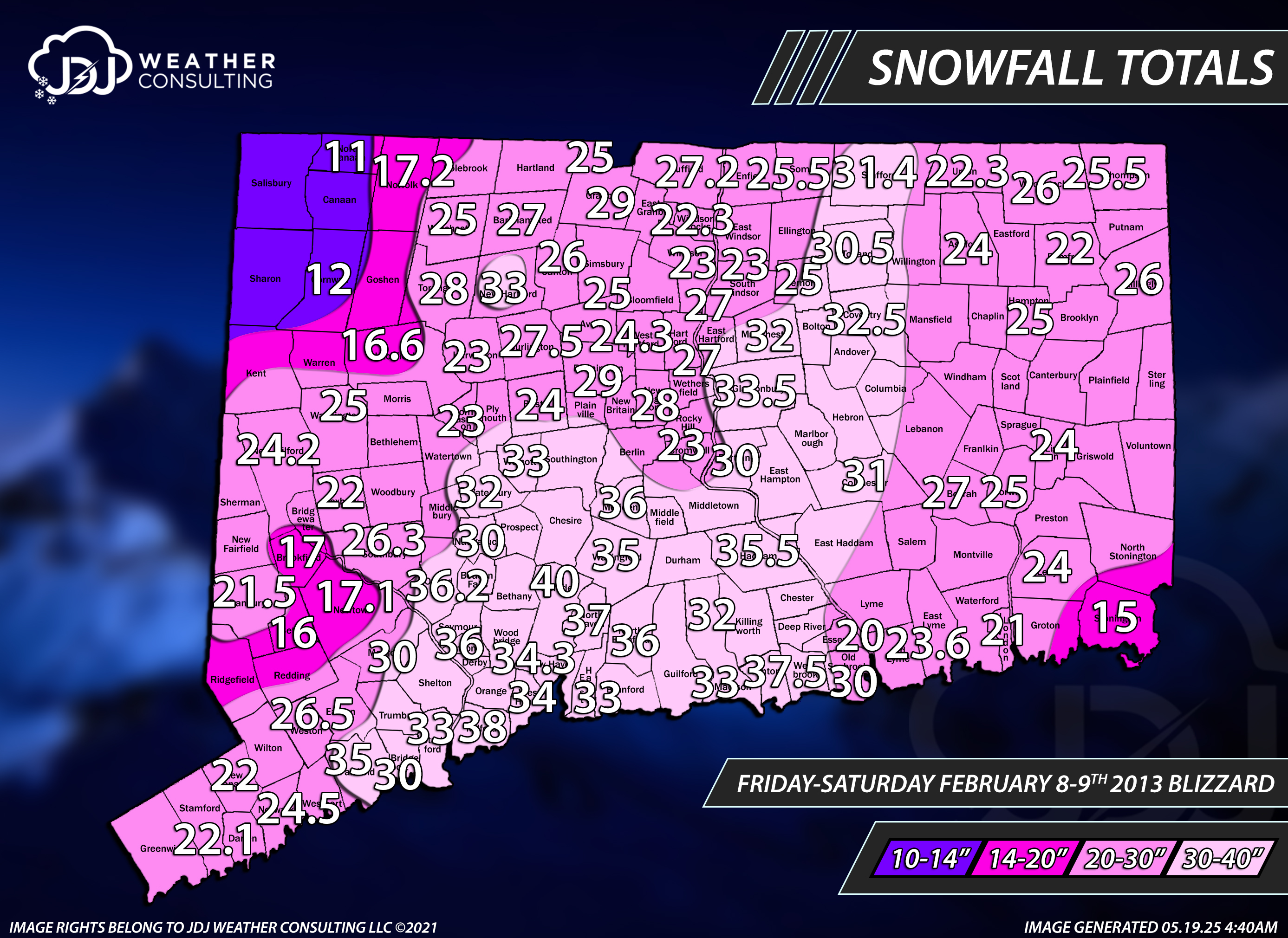
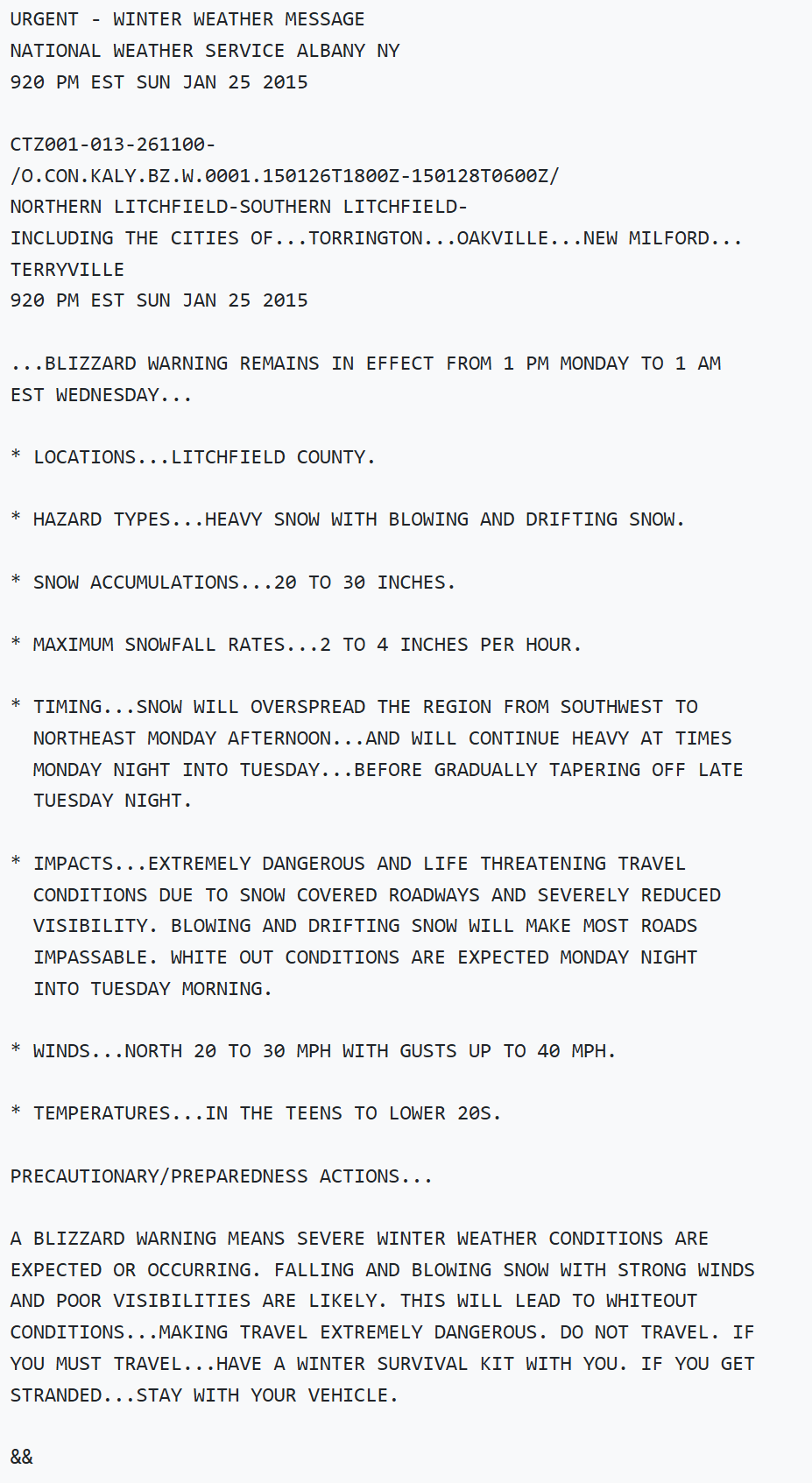
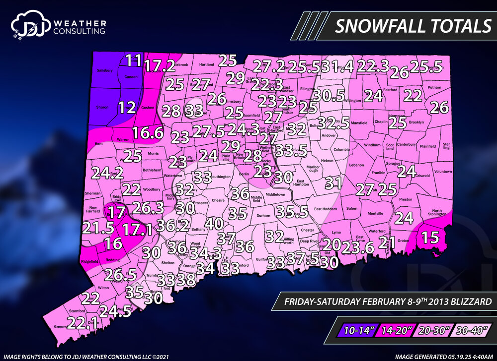
lucky you, theres been 2 here in the last 30 years, and i missed both of them. 2011 and 2013 were it for 18+ storms since 1996. 2003 PDII was close around 16-18", missed that one too i was in Italy for a class trip...so pissed.
-

2025-2026 ENSO
40/70 Benchmark replied to 40/70 Benchmark's topic in Weather Forecasting and Discussion
Man, this La Niña event is definitely east based....no doubt about that. Hopefully we can parlay that into a Modoki El Niño next year. -
Well, probably two-thirds or more of the big snow and cold events of past winters have been beyond the reliable model range (from 20 Jan onward) so it's crazy to write off any winter this early. I believe there will be some very active weather patterns around the end of January as energy levels begin to ramp up then. Whatever sort of pattern exists in late January will undergo amplification then, best bet being a large trough just west of this region so it could be quite volatile then.
-
Iris, here. Gotta hand it to em I guess for being survivors. Annoying though, way too eager to LIVE
-

January 2026 regional war/obs/disco thread
HoarfrostHubb replied to Baroclinic Zone's topic in New England
Yep. Rain. Freezing rain. Pingers. Maybe some flakes. Blah. -
i was in Waterbury that winter so 32" was the most I've ever seen in one snowfall
-
January 2026 regional war/obs/disco thread
40/70 Benchmark replied to Baroclinic Zone's topic in New England
@weatherwizI also suggest that some more of you bookmark this. -

January 2026 regional war/obs/disco thread
Baroclinic Zone replied to Baroclinic Zone's topic in New England
Yep. 50F still possibility where people live. -
January 2026 regional war/obs/disco thread
40/70 Benchmark replied to Baroclinic Zone's topic in New England
Topped out at 33 today....still icy. @CoastalWxToday is the anniversary of my favorite jackpot-event of all time!!! -
I recall that 2017 Blizzard when I was in East Taunton. Buried. 20”. As stated before, I lost count of the number of big storms I’ve experienced since 2003. between Middleborough and East Taunton there had to have been about 10 storms 18”+.
-
Far NW CT got screwed that storm, you were dangerously close to another ho-hum 11-12" event.
-

January 2026 regional war/obs/disco thread
Lava Rock replied to Baroclinic Zone's topic in New England
Pack it in. It's ovah, lol Sent from my SM-S921U using Tapatalk -
January 2026 regional war/obs/disco thread
dendrite replied to Baroclinic Zone's topic in New England

-
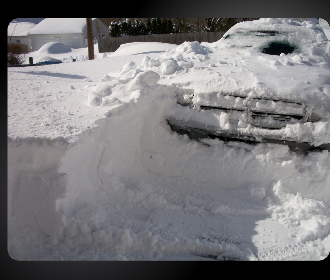
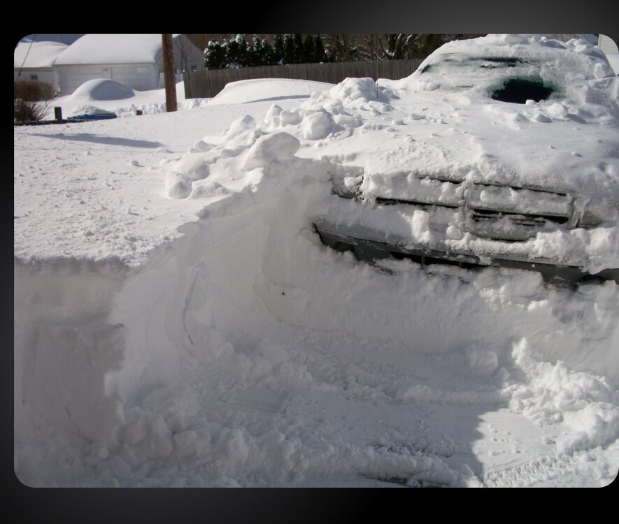
need one of these to ease the mind... that's my truck in there and my car in the background completely covered in 2013, that was such a crushing storm...
-

January 2026 regional war/obs/disco thread
Sey-Mour Snow replied to Baroclinic Zone's topic in New England
Still have a solid shot at 50s on the south coast .. especially Thursday friday -
Yeah that was me. Here you go! https://weathersigma.com/sst
-
3-6" on a 20-30" is a bust of all busts, embarrassing. We all got bamboozled by the Euro/NAM

-
Noticed a couple of wife's Crocus bulbs 'peeking' on the south side of house today. Sheesh.
-
Yet another La Nina year. This sucks.