All Activity
- Past hour
-
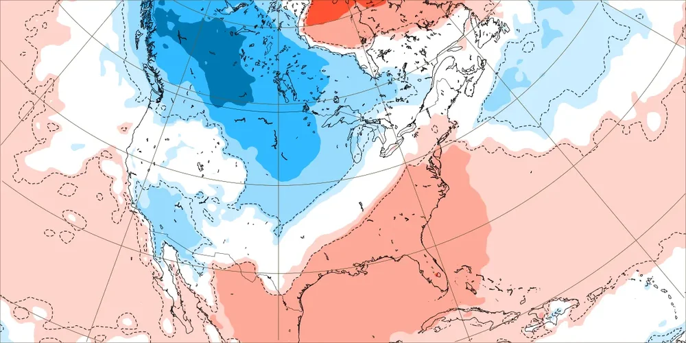
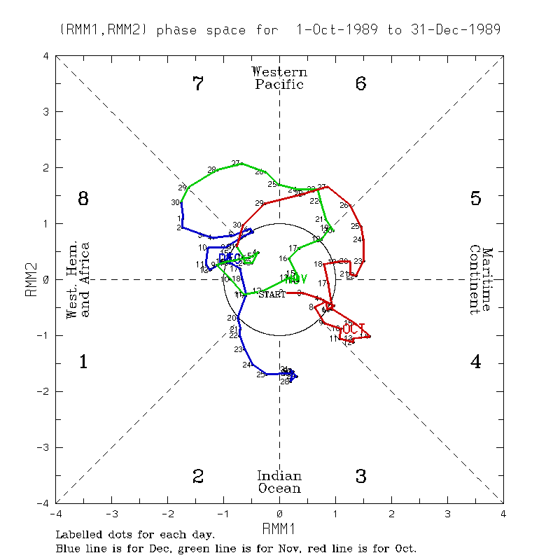
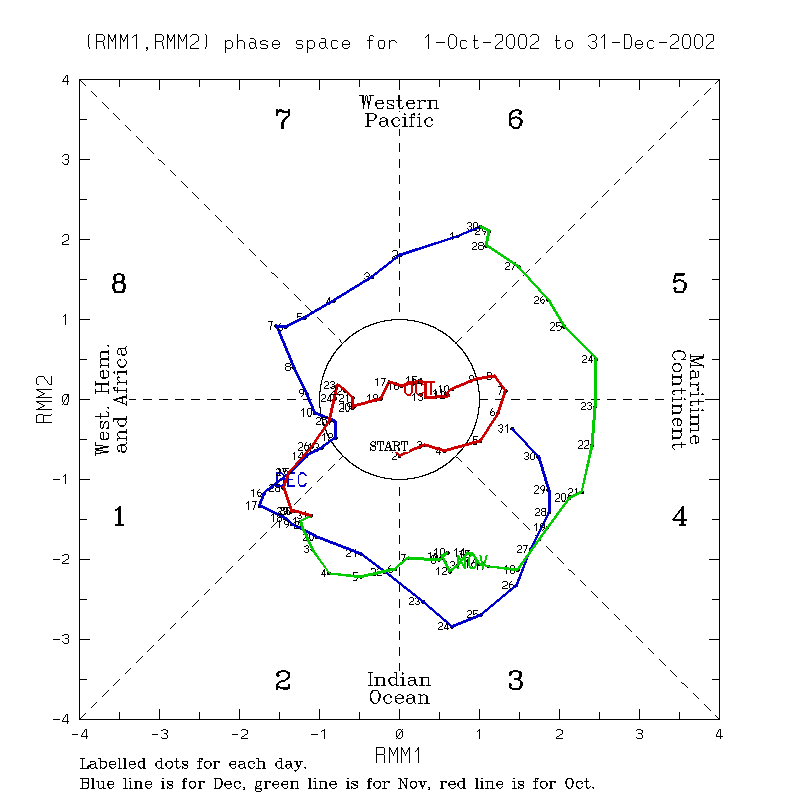
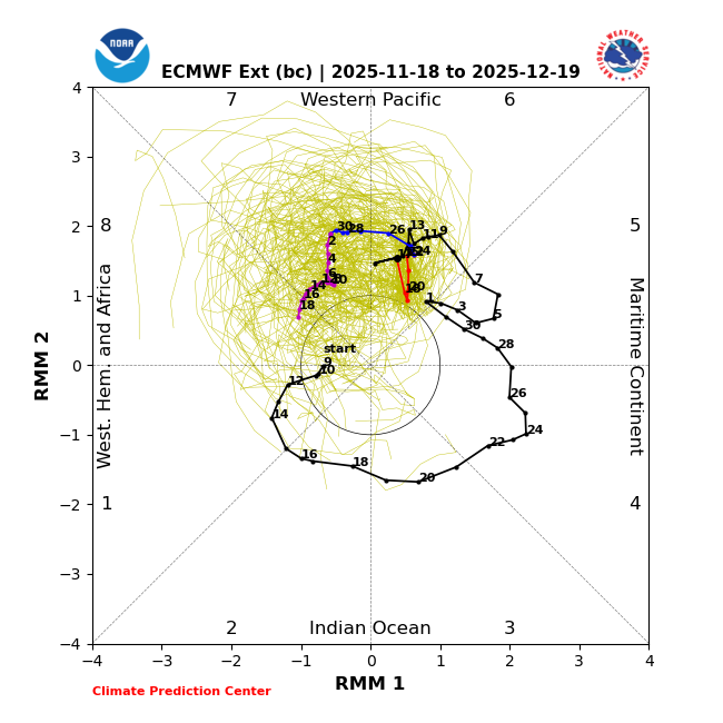
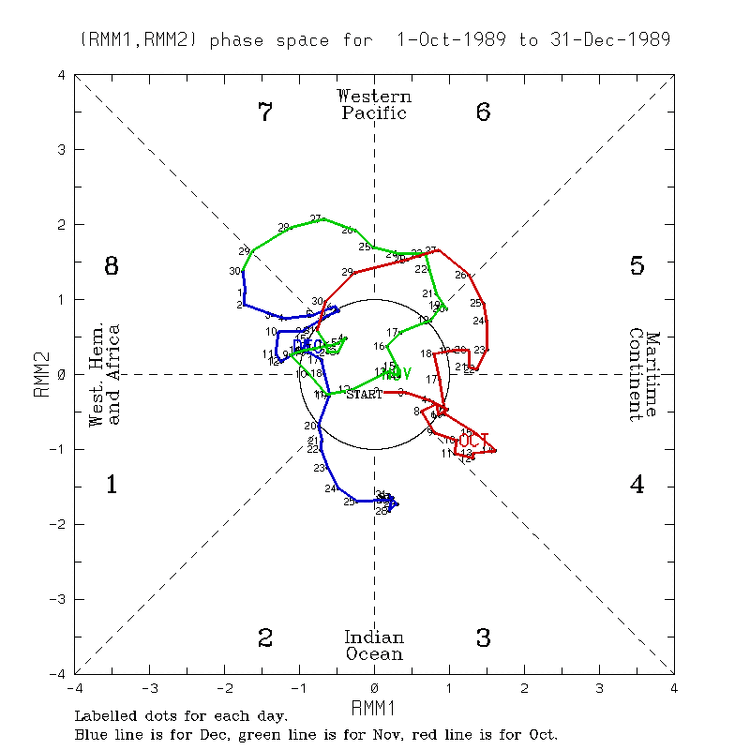
More stuff related to weak to moderate Dec phase 8 having been the coldest Dec phase 8 MJO on average: Dec 9-18 of 1989 was frigid/~tied for the coldest Dec phase 8 in the E US since 1974 along with 5.5” of snow at Baltimore (2 events) and it was weak/near and slow moving the circle: also note that it stayed frigid through this very weak phase 1 and the moderate phase 2: About tied with the frigid 1989 was the very cold 12/6-9/2002. Note that this phase 8 wasn’t too far outside of the circle (moderate phase 8): Temperatures are based on Baltimore as an E US proxy.

-

2025-2026 ENSO
brooklynwx99 replied to 40/70 Benchmark's topic in Weather Forecasting and Discussion
like this is just a fail. the stronger Pacific jet actually helps in Ninas most of the time, not hurts
-
.37 last night .81 for November somethings gotta give soon…
-
Back to the future: Ensemble qpf storm track more or less southern Plains to the northeast USA next 16 days. Ensembles have no snow prior to D10. but between D10-16 all ensembles try to bring snow accumulation down to the coasts (climo influence?). Nov 30th for now is the EPS next target day for a possible wind advisory. That's D11. Let see if I cant get D1 right... NAEFS has us chilling a bit in early Dec. Have a good day! Thanks for all the overnight reports.
-

Central PA Fall Discussions and Obs
Voyager replied to ChescoWx's topic in Upstate New York/Pennsylvania
Can you all guess where I was??? lol -
-
2025-2026 ENSO
brooklynwx99 replied to 40/70 Benchmark's topic in Weather Forecasting and Discussion
that's transient. models have vastly underdone the cold spell near Thanksgiving already and whatever brief warmup occurs around the start of the month won't last long -
LOL stop posting
-

November 2025 general discussions and probable topic derailings ...
dendrite replied to Typhoon Tip's topic in New England
Ginxy AI coming in 3, 2, 1… -
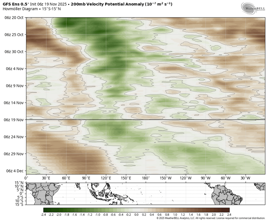
For the people who are confused or don't know what potential means: 6z GFS: 0Z Euro:
-
.43" of rain. Wasn't expecting that.
-

November 2025 general discussions and probable topic derailings ...
dryslot replied to Typhoon Tip's topic in New England
I think he was laughing at me because I wasn’t there this morning....... 016578000124369-88-2-11192025071700-W1000496.mp4 -
.thumb.png.4150b06c63a21f61052e47a612bf1818.png)
November 2025 general discussions and probable topic derailings ...
HIPPYVALLEY replied to Typhoon Tip's topic in New England
Scooter says fake af. -
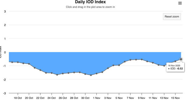
PDO was -0.92 last update, IOD weakening as well.
-

November 2025 general discussions and probable topic derailings ...
Lava Rock replied to Typhoon Tip's topic in New England
fix your snow sig, it's 2025-2026 -
The EPS much like most recent winters is getting beaten by the GEPS/GEFS in that range in regards to that E Pac/AK pattern....the 00Z run is again trying to build a SER post D12 again. I think part of what is happening is the Pac is still progressive so the EPS tries to develop these wild storms like Panhandle hooks and cutters and the flow just is not allowing for that type of activity to end up happening. As a result, there is much less SER in the end. Also the GEFS have backed away a bit from the -PNA magnitude the last 2 days on the ensembles after D10. The most glaring bad news I see in last 2-3 days is the flow is still just screaming. You can look at the last 3-4 GFS Op runs alone to see how we went from dumping cold into the W to the dump now despite going E does not make it significantly far into the Mid-South or SE because the progression of everything. Until that problem goes away we ain't seeing any consistently stormy pattern for the NE or MA
-
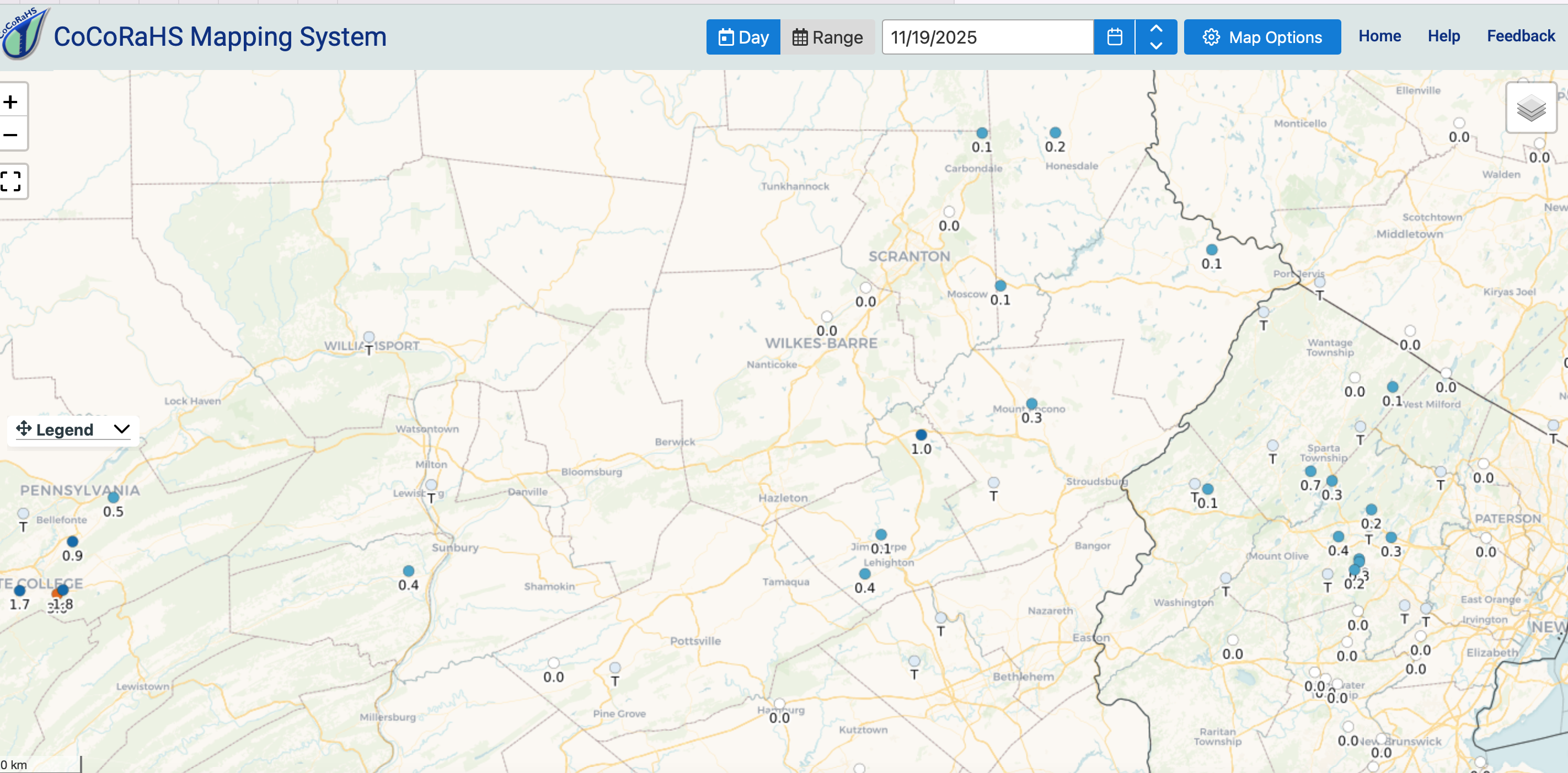
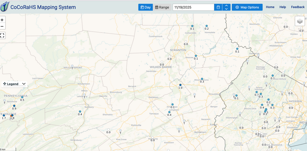
Processes: Cannot circumvent checklists... pilots don't and they fly us successfully. I got a little lazy...circumvented processes. Saw the trend in HRRR/RAP/RRFSA prior to 14z/18 yesterday, accepted HRRR resulting in an F forecast. Global CMCE an EPS ensembles (GEFS, SREF and SPC HREF snowfall terrible) had the axis right which was near I80 but amounts below 2" on 10-1. That should have cautioned me on the 12z/18 verbatim HRRR post. ANDDDD when we're on the gradient edge of qpf, caution flag. I've grown confident in the ECAI but it failed miserably on the north fringe this morning and the EC OP through 00z/19 was lacking. 12z and 18Z/18 HRRR were very similar then I saw the 00z/19 HRRR drop back down to I80--wasnt sure it would hold there. It did. Bottom line: Follow processes ALWAYS inclusive of merging ensembles and being careful on the gradient edge. I sure hope to remember this lesson. Wantage Trace flurries and qpf... basically nil. Attached CoCoRaHs snowfall.
-
0.17" at the house 0.78" now for November
-

November 2025 general discussions and probable topic derailings ...
kdxken replied to Typhoon Tip's topic in New England
36° no wind, total sunshine. Perfect day to split some wood. Sign me up for a few more.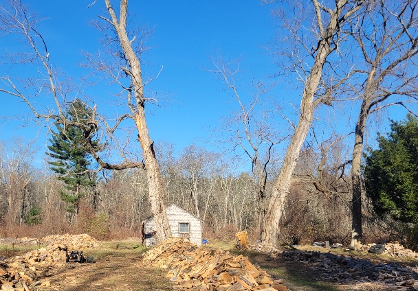
-

November 2025 general discussions and probable topic derailings ...
Torch Tiger replied to Typhoon Tip's topic in New England
November is a winter month. -
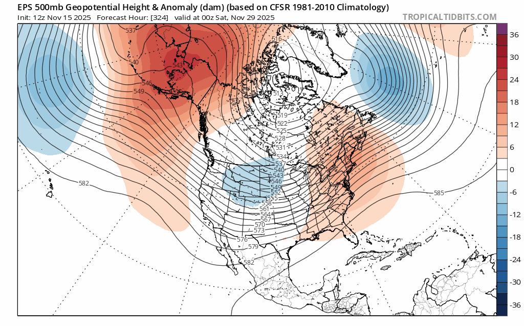
IF the 11/18 bc version of the extended EPS were to be right, you couldn’t ask for a better position of the MJO in Dec/Jan: just outside the circle in phase 8 (and very slow moving making it last longer would be a big bonus) is about the coldest on average in the E US as it’s colder than strong phase 8 on average (though there’s always lots of variation of course): if you asked me to place it in a better place and speed of movement in Dec or Jan I couldn’t:
-

Central PA Fall Discussions and Obs
pasnownut replied to ChescoWx's topic in Upstate New York/Pennsylvania
If he shits his pants enough... it will be no matter the weather. -
Central PA Fall Discussions and Obs
pasnownut replied to ChescoWx's topic in Upstate New York/Pennsylvania
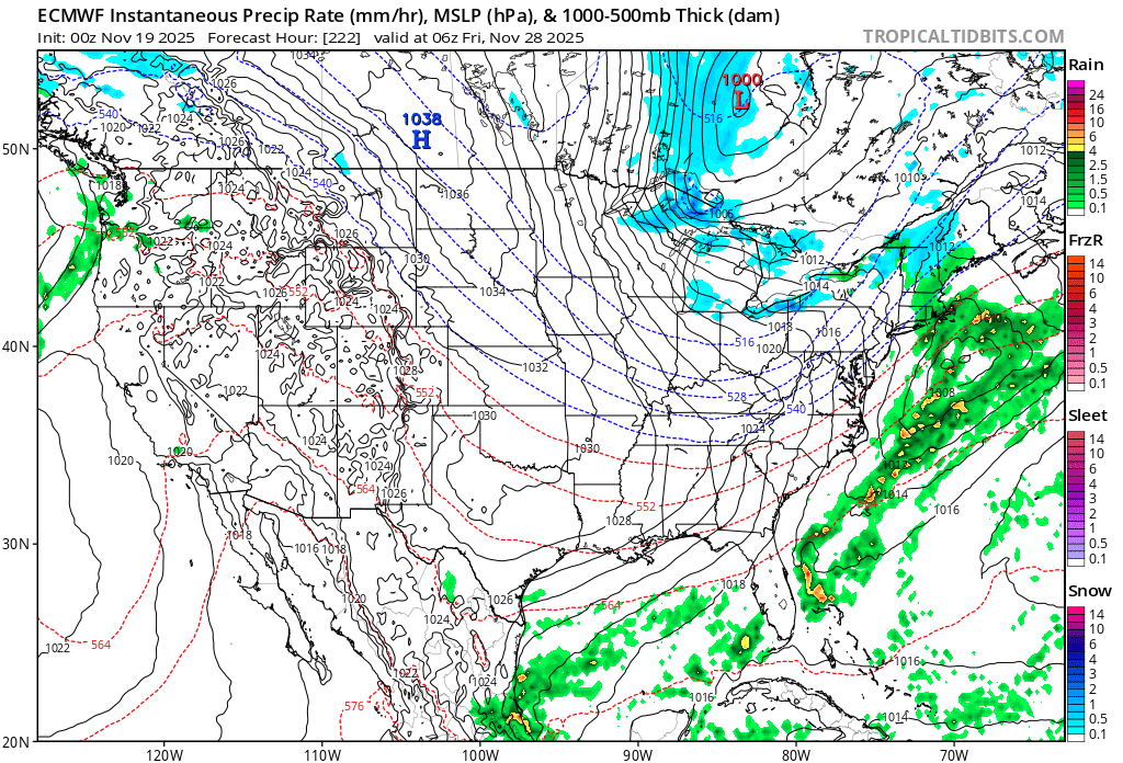
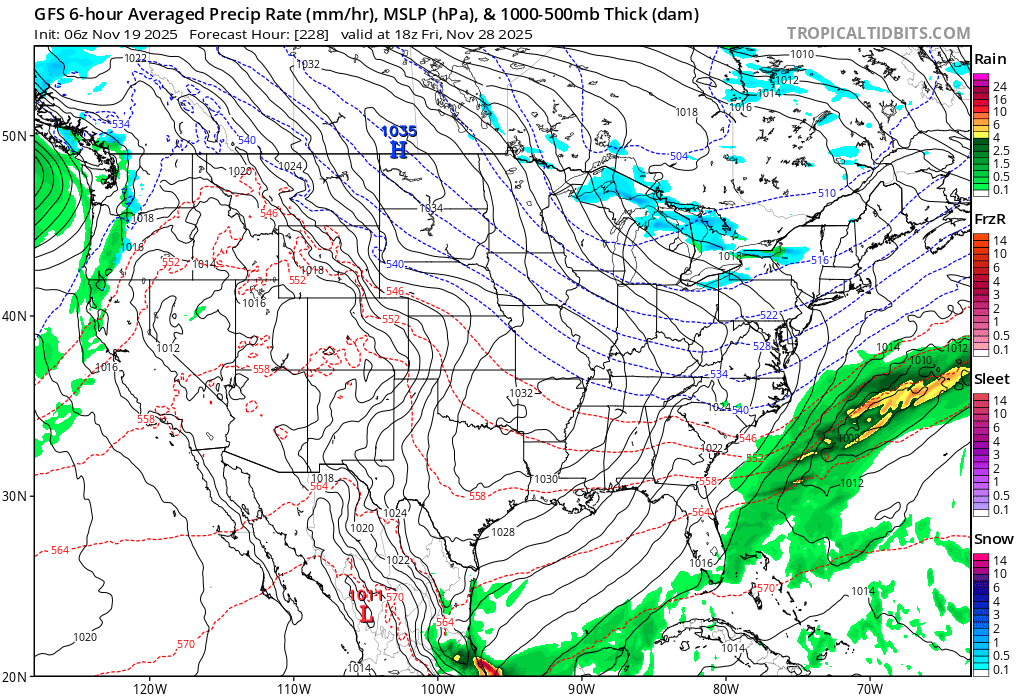
Black Friday may be white for wester/northers. Wet for rest. been consistently showing up, but normal caveats apply. -

November 2025 general discussions and probable topic derailings ...
weatherwiz replied to Typhoon Tip's topic in New England
Ahhh good thought, I do still have that in there. I also need to remember to shut off the valve to the outside water faucet. -
Latest (yesterday’s) Euro Weeklies for 12/1-7 fwiw shows it warmer than normal in much more than FL though we’ll see whether this cools off today considering the colder end of Nov (lots of model volatility currently):